Cooler Temperatures this Week. Monitoring an Outbreak of Much Colder Air for Next Week
DEC. 30, 2024
Weather Highlights for the Week
- A high fire danger will be in place across the Hill Country Monday afternoon
- A strong cold front will move across the area Monday night, bringing much cooler air for Tuesday and the remainder of the week
- No rain is forecast through Saturday
- Temperatures are predicted to trend much cooler next week
Discussion
After several days with spring-like temperatures, colder air will make a return to Texas this week. Monday looks to be the last really warm day our region is going to see for a while. Much cooler air is forecast to spread south into our area Monday night, with cooler readings remaining in place through late week. While milder temperatures are expected to return this weekend, forecasts call for a strong cold front to move across our area late Sunday, and is expected to bring much colder air for all of next week.
A trough of low pressure moving into the Plains out of the central Rockies on this Monday is causing a strengthening pressure gradient across the state. This is expected to cause the development of strong and gusty winds Monday afternoon—especially across the western half of the state, including the Texas Hill Country. Across the Hill Country, westerly winds of 10-20 mph with gusts to 35 mph are forecast through late afternoon. Across Central Texas and the middle Texas coast, southerly winds of 10-15 mph with occasional gusts to 25 mph are forecast.
Monday’s weather will be sunny and unseasonably warm, thanks to the westerly and southerly winds. High temperatures are forecast to be in the mid and upper 80s across the Hill Country, the mid-80s across Central Texas, and the low 80s across the coastal plains.
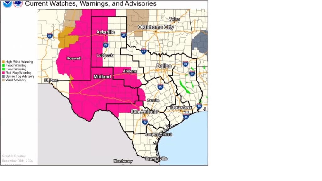
The combination of gusty winds, well-above average temperatures, and low relative humidity readings will cause critical fire weather conditions Monday afternoon across West Texas and most of the Texas Hill Country. The National Weather Service has posted a Red Flag Warning for these areas (the counties highlighted in pink below) through 6 pm.
A Red Flag Warning means conditions are in place that will cause an increased risk of fire danger, and any fires that do develop will spread quickly.

Fire weather conditions are forecast to improve some Monday evening when winds decrease and relative humidity levels increase.
A strong cold front associated with the advancing trough is forecast to push south across Texas Monday afternoon and Monday night. The front is forecast to reach the northern Hill Country Monday evening, move across the Austin area shortly after midnight, then move off the middle Texas coast before daybreak Tuesday. The atmosphere will be too dry for any rain along the front. Behind the front, the wind will shift out of the north with speeds of 10-15 mph.
The cold front will bring much cooler air for Tuesday and the remainder of the week. Sunny and dry weather is forecast through Friday.
- Lows Tuesday morning will include the low and mid-40s across the Hill Country, the upper 40s across Central Texas, and the low 50s towards the coast
- High temperatures Tuesday will generally be in the low and mid-60s
- Lows Wednesday and Thursday mornings are forecast to be in the mid-30s across the Hill Country, the upper 30s across Central Texas, and in the low to mid-40s across the coastal plains
- High temperatures Thursday and Friday are forecast to be in the low and mid-60s
Milder temperatures are forecast this weekend as southerly winds return off the Gulf. Expect a mostly sunny sky Saturday, followed by a mostly cloudy sky on Sunday. A few spotty light rain showers will be possible for areas along and east of Interstate 35 Sunday afternoon and Sunday night as moisture levels increase ahead of the next cold front. High temperatures Saturday are forecast to generally be in the mid-60s. Highs Sunday are forecast to be in the low 70s.
Next Week
A change to a much colder weather pattern is forecast to take place early next week as a ridge of high pressure builds north along the West Coast and a downstream trough develops across the eastern half of the country. This setup will allow very cold Canadian air to spread south across the central and eastern U.S. all of next week. The latest data indicates the coldest air will generally be focused mainly across the eastern and southeastern U.S. However, Texas will still see some very chilly air.
Forecasts call for leading edge of the cold air to spread south across Texas next Sunday night. Breezy and much cooler weather looks to follow on Monday and all of next week as additional surges of cold air look to spread to the south and southeast.
Forecast highs next week are predicted to be around 50-52 degrees. Lows next Tuesday through Friday are forecast to be in the upper 20s across the Hill Country, be around 30 degrees across Central Texas, and in the low to mid-30s across the coastal plains. Somewhat milder temperatures are forecast next weekend.
Stay tuned for additional updates on next week’s cold outbreak, including the possibility for any precipitation.
Bob


Social Media