A Threat for Severe Storms Thursday
DEC. 26, 2024
Atmospheric conditions are expected to be favorable for the development of scattered strong to severe thunderstorms from the eastern Hill Country, southeast to the middle Texas coast late this morning trough early Thursday evening. In a setup somewhat similar to what occurred Tuesday evening, forecasters are monitoring a wave of low pressure and its associated Pacific cold front that are currently moving southeast out of Northwest Texas. The trough is beginning to pull warm and moist Gulf air north through the eastern half of Texas, causing the atmosphere to become to become weakly to moderately unstable.
Scattered rain showers and isolated thunderstorms are forecast to develop and increase in coverage across the region this morning as the atmosphere grows increasingly unstable. However, the best chance for rain and thunderstorms is expected to occur just ahead of and along the Pacific cold front as it tracks to the southeast. High resolution forecasts call for the front to reach the eastern Hill Country late Thursday morning, move across the Austin/Interstate 35 corridor midday into the early afternoon, the eastern half of Central Texas early to mid afternoon, and the coastal region in the late afternoon to early evening. Behind the cold front, the chance for rain will diminish.
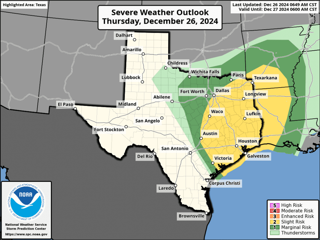
The Storm Prediction Center has placed the eastern third of Texas, extending west to Austin, under a Slight Risk, or 2 out of 5 risk, for severe thunderstorms through Thursday night. The eastern Hill Country has been placed under a 1 out of 5 risk. Today’s greatest severe weather threat is expected to be from large hail and damaging winds. However, a couple of isolated tornadoes cannot be ruled out.

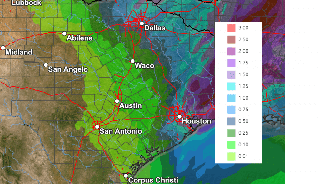
Rain amounts through Thursday evening are not expected to be very significant. Totals across the Hill Country and Central Texas regions are forecast to generally remain under a quarter inch. Slightly higher totals up to three quarters of an inch are forecast for Wharton and Matagorda Counties. Isolated heavier totals will be possible from some of the stronger thunderstorms.
NWS Rainfall Forecast Valid through 6 am Friday:

Sunny and dry weather is forecast across the region Friday. In fact, a dry weather pattern is forecast this weekend, continuing through late next week as a stable ridge of high pressure sets up across the western and southwestern U.S. Mild temperatures are forecast through the weekend and into Monday, with highs in the 70s. A Canadian cold front is predicted to push across the area Monday night that will bring cooler temperatures for Tuesday and most of next week. The temperature is forecast to stay above freezing for most all locations next week.
Bob


Social Media