Friday morning’s temperatures were the coolest observed so far this autumn. According to LCRA’s Hydromet, lows across the Hill Country and Central Texas generally ranged between the mid 30s and the mid-40s. Across the coastal plains, lows were generally in the mid and upper 40s. The lowest observed temperature was 33 degrees at gauges located just northwest of Austin, to the west of Junction, and in western Bastrop and Fayette Counties. In Austin, Camp Mabry reported a low of 42 degrees, while Austin-Bergstrom Airport recorded a low of 37.
Weather conditions are quiet and fall-like as we close out the workweek. However, milder temperatures will be returning tonight and Saturday as southeasterly breezes return to the area. Wind speeds will be light Friday afternoon and Friday night, but look to increase to 10-15 mph Saturday afternoon. Expect a mostly sunny sky through Saturday.
- High temperatures Friday are forecast to be in the upper 70s
- Lows Saturday morning will be in the low and mid-50s
- High temperatures Saturday are predicted to be near 78-80 degrees
- Lows Sunday morning will range from the low 60s across the Hill Country, to the upper 60s near the coast
Numerous changes in the weather are forecast to take place Sunday into Monday as a West Coast trough of low pressure tracks from northern Mexico to the southern Plains states. To the east of the trough, clouds and moisture will begin to stream north into Texas from the Gulf of Mexico beginning Sunday morning. As atmospheric moisture levels increase, isolated to scattered rain showers are forecast to develop across the region Sunday afternoon into Sunday evening. The probability for rain will be near 30-40 percent, with rain amounts staying below a tenth of an inch.
Heading into Sunday night, attention will turn to West Texas where a Pacific cold front associated with the upper trough will be pushing to the east. With a moist and a unstable atmosphere in place, forecasts call for a large area of rain and thunderstorms to develop along and just behind the cold front. The area of rain and storms is predicted to spread east across the Hill Country and Central Texas regions Sunday night, reaching the coastal region Monday morning.
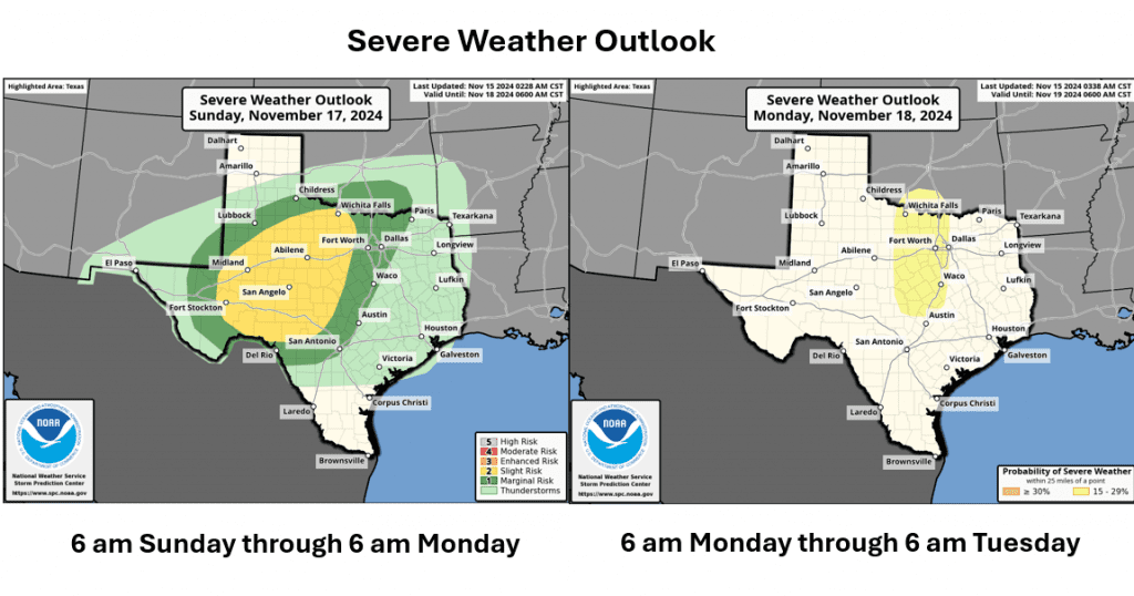
There will be a threat for some of the storms to be strong to severe Sunday night. While the greatest severe weather threat is expected to be across West and North Texas, there will also be a threat for severe storms across the Hill Country and the northern Counties of Central Texas. The Storm Prediction Center has placed the western and central Hill Country under a Slight Risk, or 2 out of 5 risk, for severe storms through 6 am Monday. A 1 out of 5 risk for severe storms extends east to the I-35 corridor. A risk for severe storms is predicted to extend south close to the Austin area from late Sunday night into Monday morning.

The primary severe weather threat is expected to be damaging downburst winds. However, a threat for large hail and isolated tornadoes cannot be entirely ruled out.
The area of rain and storms is forecast to spread east across the Hill Country after midnight Sunday night, reaching the Austin/Central Texas region near or just after sunrise Monday morning. The area of rain and thunderstorms is forecast to spread across the coastal plains region Monday morning into Monday afternoon. The rain should taper off across the Hill Country after sunrise Monday, the Austin/Central Texas area around midday Monday, and the coastal area in the mid to late afternoon.
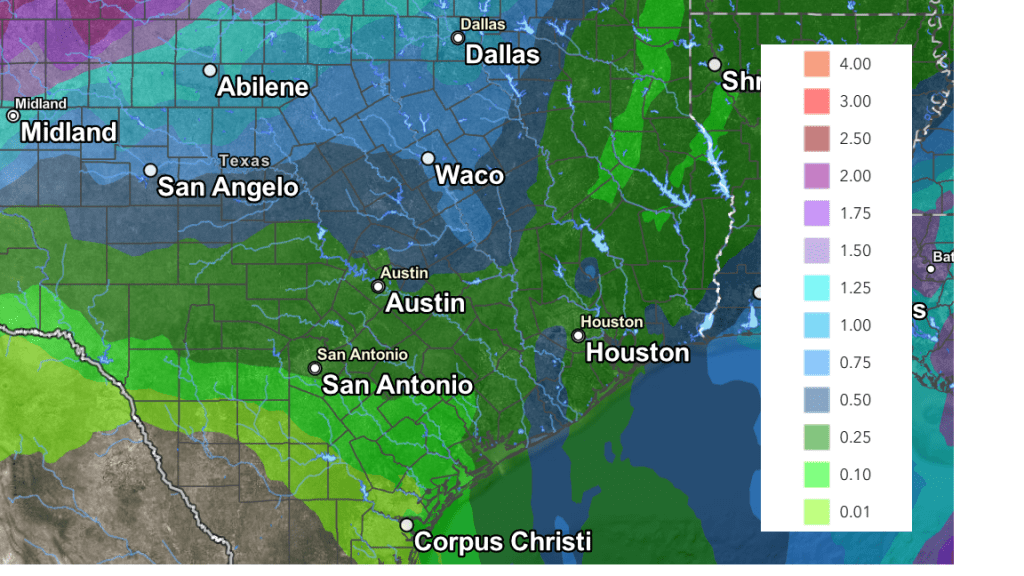
Rainfall from Sunday and Monday’s rain and storms is predicted to heaviest across West and North Texas, with lower totals across the Hill Country and Central Texas. The National Weather Service’s rainfall forecast through Monday calls for totals of 0.5 to 1 inch across the northern Hill Country and the northern counties of Central Texas, with totals of 0.25 to 0.5 inches at most other locations. Isolated heavier totals will be possible.
NWS Rainfall Forecast Valid through 6 pm next Wednesday:

Drier and slightly cooler air is forecast behind the cold front Monday afternoon as the sky clears from west to east. Breezy north winds with gusts to 25 mph are forecast Monday afternoon into Monday evening. Wind speeds should decrease late Monday night into Tuesday. The sky will be sunny Tuesday.
- High temperatures Monday will range from the low 70s west, to the low 80s near the coast
- Lows Tuesday morning will include the mid-40s across the Hill Country, the upper 40s across Central Texas, and the low 50s near the coast
- Highs Tuesday will be in the upper 70s.
- Lows Wednesday morning will range from the low and mid-40s across the Hill Country, to the low 50s near the coast
A stronger, Canadian cold front is forecast to spread south across the area late Tuesday night into Wednesday morning, bringing a surge of cooler air. No rain is expected with the front. Northwesterly winds will increase to 10-20 mph, with gusts to 30 mph Wednesday into Wednesday evening.
Cold air behind this front may bring the first freeze of the season to parts of the Hill Country next Thursday morning. Sunny and slowly warming temperatures are predicted for late week, continuing into the following weekend.
Lows Thursday morning are forecast to be in the low and mid-30s across the Hill Country, in the upper 30s to near 40 degrees across Central Texas, and in the low 40s across the coastal plains.
Tropical Weather Update
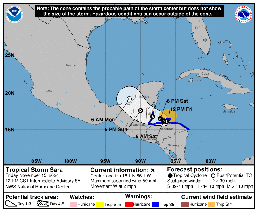
Tropical Storm Sara developed over the western Caribbean Sea Thursday. As of midday Friday, the system was still over the western Caribbean and centered about 170 miles east of Belize City, Belize. Maximum sustained winds were near 50 mph with higher gusts. Some slight strengthening is possible over the next couple of days as long as Sara remains offshore of the coast of Honduras.
Sara is moving slowly toward the west near 2 mph. A continued slow westward motion is expected over the next day or so, followed by a more west-northwestward motion beginning late Saturday. On the forecast track, the center of Sara will continue to move close to the northern coast of Honduras through early Saturday before approaching Belize, and then moving onshore in Belize during the day on Sunday.
After moving across the Yucatan, Sara is expected to quickly weaken, and what remains of the system when it emerges into the Bay of Campeche/Gulf of Mexico does not appear very favorable for redevelopment. Ultimately, Sara is expected to open up into a trough, though its remnant moisture will likely be absorbed in the Gulf of Mexico and spread northeast toward Florida.
Sara poses no threat to the Texas coast.

Don’t Miss Friday Night’s Super-Full Moon
Friday night’s full moon is often call the Beaver, or Frosty moon. As a bonus, Friday night’s moon is near the point in its orbit where it is closest to Earth. This makes it a supermoon. In fact, it’s the last of four supermoons in a row. Friday night, the bright, round full moon will be climbing in the east, as night falls. We’ll all find the moon glowing high in the south near midnight and dropping low in the west near sunrise.
Have a great weekend!
Bob


Social Media