A dry and quiet weather pattern is in place across the region as we kick off the new week. This quiet pattern is forecast to remain in place through late week as a weak ridge of high pressure holds in place over the region. Changes in the weather pattern are predicted for next week as rain returns to the forecast along with some indications for cooler temperatures.
Monday afternoon through Tuesday night
Expect a sunny sky with warm afternoons and cool night. High temperatures both days are forecast to be in the low and mid 80s. Lows Tuesday and Wednesday mornings will range from the low 50s across the Hill Country, to the mid and upper 50s at all other locations. Northeasterly winds Monday afternoon look to become southeasterly on Tuesday. Wind speeds should be in the range of 5-10 mph.
Wednesday and Wednesday Night
A trough of low pressure pushing east out of the Rockies will help to push a Pacific cold front across the state on Wednesday. Unfortunately, there won’t be enough moisture in place to cause any rain along the front. The cold front is predicted to reach the Hill Country around midday, then move across Central Texas and the coastal plains regions Wednesday afternoon. Dry and slightly cooler air will follow the cold front. Expect a mostly sunny sky. Northwesterly winds with speeds of 10-15 mph will follow the front Wednesday afternoon and Wednesday evening.
Highs Wednesday will range from the upper 70s across the Hill Country, to the low and mid-80s elsewhere. Lows Thursday morning will include the mid-40s across the Hill Country, the upper 40s to low 50s across Central Texas, and the mid-50s across the coastal plains.
Thursday through Saturday
Northerly breezes are forecast Thursday, but southeasterly breezes look to return Friday, bringing a slow return of moisture. Expect a sunny to mostly sunny sky through the period.
- Highs are forecast to be in the mid-70s Thursday, the upper 70s Friday, and the low 80s Saturday.
- Lows Friday morning will include the mid-40s across the Hill Country, the upper 40s across Central Texas, and the low 50s across the coastal plains
- Lows Saturday morning will generally be in the low and mid-50s
- Low Sunday morning are forecast to be in the low and mid-60s, and be near 70 degrees across the coastal plains
Next Sunday into Monday
Forecast solutions call for a trough of low pressure to track from northwestern Mexico, northeast to the Four Corners region. The tough is expected to pull considerable moisture north from the Gulf of Mexico, resulting in the development of a mostly cloudy sky. There will be a slight chance for some spotty light rain across the region beginning Sunday evening, continuing through Monday afternoon. Rain amounts, if any, should total under a tenth of an inch.
The chance for rain will diminish late Monday as the trough exits to the northeast. Partly cloudy and dry weather is forecast next Tuesday.
Forecasts call for a large trough of low pressure track northeast out of Mexico and move across the Panhandle region next Wednesday into Thursday. This system is predicted to bring a better chance and a more widespread coverage of rain showers and scattered thunderstorms to the region next Wednesday into Thursday.
A fairly potent cold front is forecast to push south across the area next Wednesday and is expected to bring some of the coolest air so far this autumn. High temperatures next Thursday and Friday are forecast to be in the 60s. Lows next Thursday and Friday mornings are forecast to fall to the mid and upper 30s across the Hill Country, the mid-40s across Central Texas, and the upper 40s across the coastal plains.
Tropical Weather Update
Hurricane Raphael fell apart rapidly across the west-central Gulf of Mexico over the weekend. The system was declared a post-tropical system Sunday afternoon.
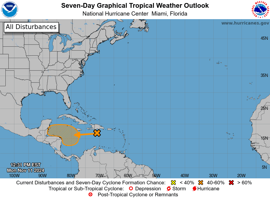
NHC forecasters are monitoring an area of disorganized showers and thunderstorms to the south of Hispaniola over the central Caribbean Sea associated with a tropical wave. This system is expected to move slowly westward during the next few days, and environmental conditions appear conducive for gradual development. A tropical depression could form late this week or this weekend while meandering over the western Caribbean Sea. NHC forecasters are giving this system a 50 percent chance for tropical development over the next seven days.

This system doesn’t look to pose a threat to Texas as steering currents should eventually take it off to the northeast.
Evening Passes of the International Space Station
The ISS will be making visible passes across the area each evening this week (except for Friday). The most favorable pass is expected to occur Tuesday evening, lasting for 6 minutes.
Check out all of the viewing information for you location at spotthestation.nasa.gov
Have a good week!
Bob


Social Media