An active period of weather is expected to take place across the eastern Hill Country, Central Texas, and coastal regions beginning late Monday afternoon, continuing through the overnight hours. There will be a risk for some of the storms to become severe around the Austin area and the eastern counties of Central Texas Monday evening and Monday night.
A vigorous trough of low pressure located over eastern New Mexico is forecast to lift to the northeast late Monday, and will help to push a Pacific cold front eastward across Texas Monday evening and Monday night. In advance of the cold front, expect a cloudy and humid afternoon, with 40-50 percent chance for isolated to scattered rain showers and isolated thunderstorms. Rain amounts should total less than a quarter inch. High temperatures Monday are predicted to be in the mid and upper 80s. Expect southerly winds with speeds of 10-20 mph, and gusts to near 30 mph.
Forecasts call for the cold front to reach the Hill Country late Monday afternoon/Monday evening, the Austin/Interstate 35 corridor between roughly 11 pm and 2 am, and the coastal area between 6 and 8 am Tuesday. High resolution forecasts call for an area of rain showers and thunderstorms to rapidly develop along the cold front when it reaches the eastern Hill Country late Monday afternoon. The area of rain and thunderstorms is then forecast to slowly spread southeast across Central Texas Monday evening. Atmospheric conditions across North Texas, extending south into Central Texas, appear somewhat favorable for the development of strong to severe storms as the line of storms moves across Central Texas.
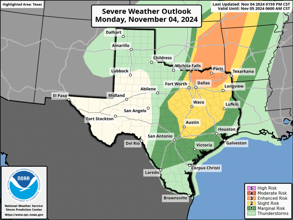
The Storm Prediction Center has placed the Austin area and the eastern half of Central Texas under a Slight Risk, or a 2 out of 5 risk, for severe thunderstorms through 6 am Tuesday. A Marginal Risk, or a 1 out of 5 risk, is forecast for the remainder of the region. The primary severe weather risk is expected to be strong and damaging straight-line winds. However there will be low probabilities for large hail and isolated tornadoes.

Forecasts call for rain and thunderstorms to persist behind the cold front across the eastern Hill Country and the Austin/Central Texas region through the overnight hours. Some pockets of locally heavy rain will be possible. The rain is forecast to taper off across the Hill Country and the Austin area by about daybreak Tuesday. The area of showers and thunderstorms is forecast to spread across the coastal region after midnight Monday night and continue through late morning Tuesday.
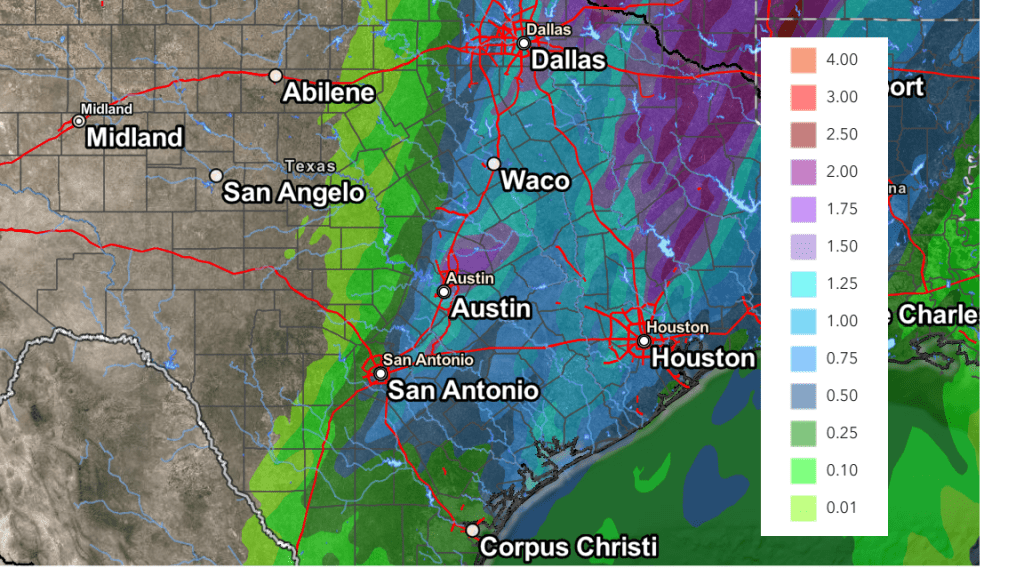
A large gradient in rainfall is predicted with Monday’s night’s rain and storms. Forecasts call for totals to average less than a quarter inch across the western and central Hill Country, but total around a half inch across the eastern Hill Country. For Central Texas and the middle Texas coast, expect totals to average close to an inch, with isolated higher totals to near 2 inches.
NWS Rainfall Forecast for the Period 6 pm Monday through 6 pm Tuesday:

Tuesday morning, the rain should taper off from west to east across the eastern counties of Central Texas and the middle Texas coast. Clouds will clear from west to east Tuesday morning through Tuesday afternoon. A mostly clear sky is forecast Tuesday night through Wednesday. Noticeably cooler temperatures will develop behind the cold front.
- High temperatures Tuesday will range from the upper 60s across the northern Hill Country, to the mid-70s across the coastal plains
- Lows Wednesday morning will include the low and mid-40s across the Hill Country, the upper 40s across Central Texas, and the mid-50s across the coastal plains
- High temperatures Wednesday are forecast to be in the mid and upper 70s
- Lows Thursday morning will range from the mid-50s west, to the mid and upper 60s near the coast
Clouds and moisture are forecast to rapidly return off the Gulf of Mexico Wednesday night ahead of a new trough of low pressure that will be sinking south out of the southern Rockies. This trough is forecast to reach the Four Corners region late Thursday, then lift northeast to the southern Plains on Friday. As moisture levels increase, rain showers and isolated thunderstorms are forecast to develop across the region late beginning late Wednesday night. Periods of rain showers and isolated thunderstorms look to continue Thursday through Friday as atmospheric lift increases ahead of the trough. The most favorable period for rain is forecast to occur Thursday afternoon into Friday. The chance for rain is forecast to decrease late Friday night into Saturday morning as a Pacific cold front moves across the area, bringing drier and cooler air.
Rain amounts between Wednesday night and Saturday are forecast to generally average between 0.25 and 0.5 inches. Isolated totals to near 1 inch will be possible across the northern Hill Country and the northern counties of Central Texas.
A mostly sunny to partly cloudy sky is forecast this weekend, continuing through the first half of next week. Daily high temperatures are forecast to be in the mid and upper 70s, rising into the low 80s next Tuesday. Lows are forecast to be in the mid and upper 50s.
Longer-range forecasts call for a cold front to push south across our area sometime late next Wednesday or Thursday. There will be a chance for a little rain along the front, but rain amounts should stay below a quarter inch. This front looks to bring in cooler air for late next week, with highs falling to the upper 60s to low 70s, and lows in the upper 40s to low 50s.
Tropical Weather Outlook
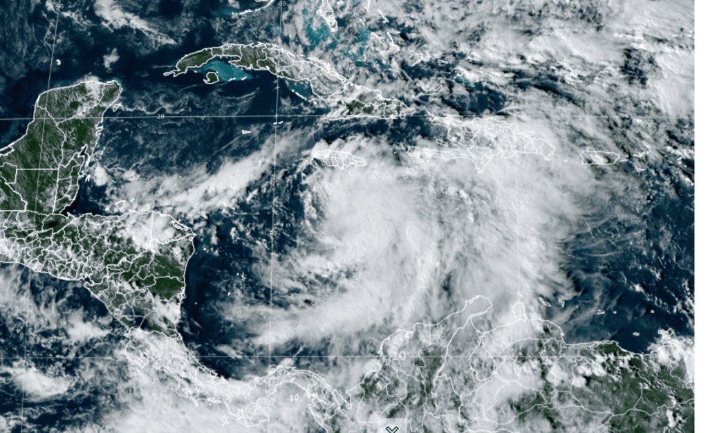
The area of disturbed weather that has persisted across the southwestern Caribbean Sea since late last week organized into a Tropical Storm Rafael Monday afternoon.

NOAA/Colorado State University/RAMMB 11-04-24 2:10 pm CST
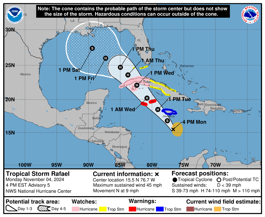
As of 4 pm CDT, the center of Tropical Storm Rafael was located about 175 miles south of Kingston, Jamaica. Rafael was moving toward the north near 9 mph. A northwestward motion is expected to begin later Monday night and is forecast to continue for the next few days. On the forecast track, the system is expected to move near Jamaica late Monday night, be near or over the Cayman Islands late Tuesday, and approach Cuba on Wednesday.
Maximum sustained winds have increased to near 45 mph with higher gusts. Steady to rapid strengthening is now forecast and the system is forecast to become a hurricane on Tuesday.

Although the system will be moving into the Gulf of Mexico later this week, it poses no threat to the Texas coast. The cold front pushing south into the Gulf late this week should turn the storm toward the central Gulf coast instead of moving further to the west. The National Hurricane Center is predicting this system to make landfall as a tropical storm or category 1 hurricane somewhere across Louisiana, Mississippi, or Alabama coasts on Friday.
Have a good week!
Bob


Social Media