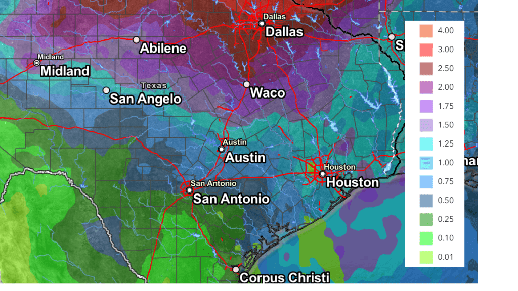
The dry and summer-like weather pattern we’ve seen through all of October will finally begin to change this week as the heat dome shifts to the east, allowing moisture to spread inland off the Gulf of Mexico. The combination of increasing moisture, a weak cold front, and passing storm system is expected to cause the development of scattered, mainly light rain showers across the area Tuesday through Friday, with the best chance for rain occurring Wednesday night into Thursday afternoon. Additional chances for rain are forecast this weekend and the first half of next week as a trough of low pressure stalls across northern Mexico. While rain is forecast throughout much of the week, I do want to caution this period of wet weather is not expected to put a significant dent in the drought. Total rain amounts through Monday are forecast to generally average around 1 inch. Temperatures do look to trend down a bit later this week, but highs are forecast to still be in the 80s.
A large trough of low pressure pushing inland across the Pacific Northwest is causing low pressure to develop across the southern Rockies, which in turn is increasing the pressure gradient across Texas. The stronger gradient is causing brisk southerly breezes and sustained speeds of 10-20 are forecast Monday afternoon through Wednesday night. Gusts to 25 mph are forecast Monday afternoon and Monday night. Occasional gusts to 35 and 40 mph are predicted for Tuesday and Wednesday.
Monday’s weather is shaping up to be partly cloudy, breezy, and quite warm. High temperatures are forecast to be in the mid-80s across the Hill Country and between 88 and 90 degrees at most other locations. Due to the increased moisture in place, lows Tuesday morning will be significantly milder, ranging from the upper 60s across the Hill Country, to the low 70s towards the coast.
Tuesday’s weather will start off with widespread low clouds. These clouds will slowly give way to a partly to mostly cloudy sky in the afternoon. There will be a 20 percent chance for a few spotty light rain showers across parts of the Austin/Central Texas area Tuesday morning through Tuesday afternoon. Rain amounts, if any, should average below a tenth of an inch. High temperatures Tuesday are forecast to be in the mid and upper 80s. Lows Wednesday morning once again look to be in the upper 60s to low 70s.
Wednesday’s weather will feature an increasing chance for rain showers and isolated thunderstorms across the area in the afternoon and evening as moisture levels increase and pool ahead of a weak cold front sagging south into Texas. The chance for rain will be near 40 percent. Rain amounts Wednesday through Wednesday evening are forecast to average under a quarter inch. High temperatures Wednesday are forecast to be in the mid and upper 80s.
The chance for rain and scattered thunderstorms will increase to around 60-70 percent across the Hill Country and Central Texas regions beginning after midnight Wednesday night and continue through Thursday afternoon as a weak Pacific cold front sags to the south, stalling just to the north of Austin. The chance for rain and thunderstorms looks to increase across the coastal plains region Thursday morning into Thursday afternoon. The threat for strong to severe storms will be low as the main forcing for storms is expected to remain well to our north, up around the Red River. The chance for rain should diminish late Thursday afternoon as the parent trough exits to the northeast. Rain amounts through Thursday afternoon are forecast to generally average around a half inch. High temperatures Thursday are predicted to be in the mid-80s.
The outlook for Thursday evening’s trick or treat activities calls for just a 20 percent chance for spotty light rain showers around the area. Otherwise, expect a mostly cloudy sky with temperatures in the 70s.
Friday, continuing through the weekend, forecasts call for the weather pattern to remain unsettled as a large trough of low pressure begins to settle south along the West Coast. Disturbances flowing around the trough and across Texas are expected to cause a 20-30 percent chance for scattered showers and isolated thunderstorms through the period. Daily rain amounts are forecast to generally average between a tenth and a quarter of an inch. Daily high temperatures are forecast to be in the low and mid-80s, with lows in the 60s.
The National Weather Service’s Cumulative Rainfall Valid through 6 pm next Monday:

For next week, forecast solutions indicate the unsettled weather pattern will continue through late week as the trough of low pressure remains parked across the western and southwestern U.S. There will be a chance for light rain each day. Cooler temperatures are forecast beginning sometime around the middle of the week when a Canadian cold front moves through the area. High temperatures late week are forecast to fall to the 70s, with lows in the 50s.
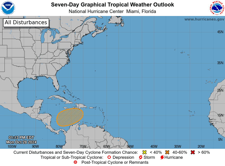
Tropical Weather Outlook
National Hurricane Center forecasters indicate a broad area of low pressure is likely to develop over the southwestern Caribbean Sea in a few days. Gradual development will be possible thereafter, and a tropical depression could form late this week or over the weekend. The system is forecast to drift northward or northeastward toward the central Caribbean Sea over the next several days. Note: this system poses no threat to the western Gulf of Mexico.

NHC forecasters are giving this system a 40 percent chance for tropical development over the next seven days.
Time Change Weekend
This weekend will be time change weekend. Daylight Saving Time will come to an end this Sunday, November 3rd, at 2 am. At that time, we will move to standard time. Remember to “fall back” and set clocks back one hour before going to bed Saturday night.
Bob


Social Media