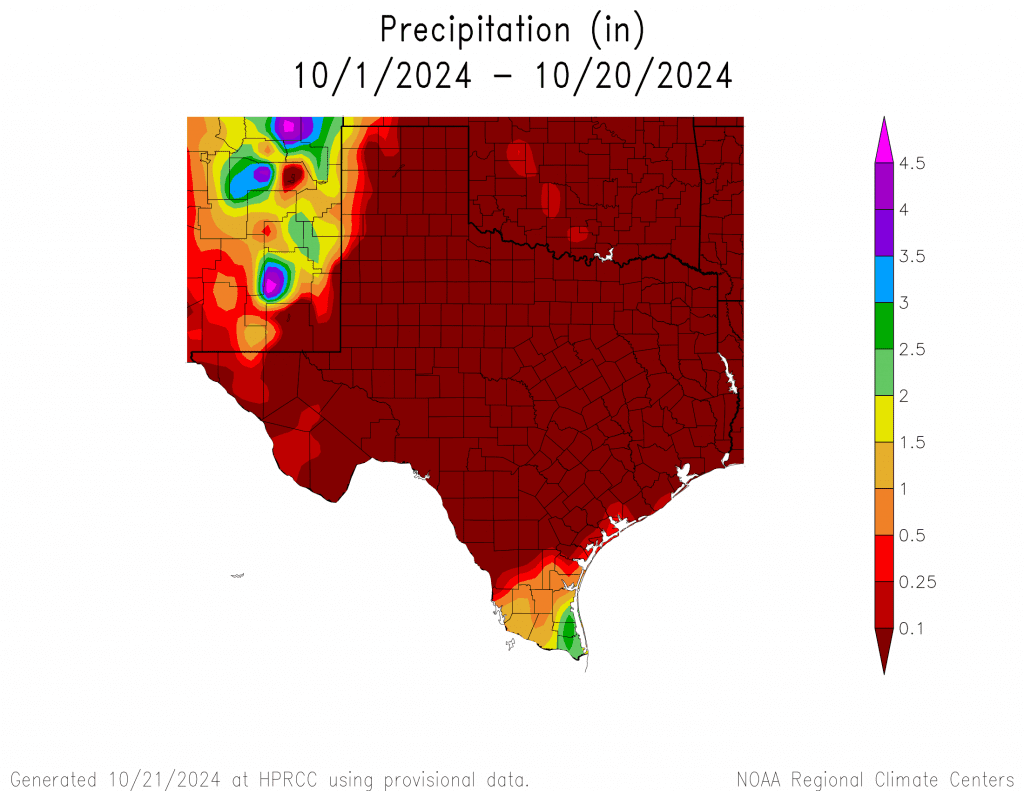
Dry and quiet weather continues across the region as we start off this last full week of October. While the recent spell of weather has been pleasant, the month has been unusually dry. All locations have reported zero, or next to zero rainfall. This development is highly unusual as October is typically the second or third wettest month of the entire year. If no rain falls between now and the end of the month, records show this will go down in record territory as the driest or one of the very driest Octobers on record.

Monday’s weather maps showed Texas and the south central U.S. remaining under the influence of a stable ridge of high pressure in the middle and upper atmosphere. To the north of the ridge, the storm track is currently positioned between the Pacific Northwest and southeastern Canada. Forecast solutions call for the storm track to remain well to the north of Texas throughout the week, continuing into early next week. As a result, the weather is expected to stay dry across our region for at least another week.
The most noticeable change in the weather this week will likely be slightly warmer temperatures—both in the afternoon and also at night. South and southeasterly breezes developing this afternoon and tonight are forecast to bring slightly more humid air north from the Gulf of Mexico. This layer of moisture will be quite shallow, but it may be just enough to cause the development of some late night and early morning clouds across Central Texas and the middle Texas coast Tuesday and Wednesday mornings. These clouds should burn off by about mid-morning.
Winds throughout the week are expected to remain fairly light, with speeds of just 5-10 mph.
- High temperatures Monday afternoon are forecast to generally be in the mid-80s
- High temperatures Tuesday are predicted to be in the upper 80s
- High temperatures Wednesday through Friday are forecast to be near 88-90 degrees across the Austin/Central Texas and coastal regions, and in the upper 80s across the Hill Country
- Low temperatures throughout the week are forecast to be in the low 60s.
Very little change in the weather is forecast for the upcoming weekend. Forecasts do call for a weak cold front to sink south across Texas Saturday into Saturday night. The atmosphere will be too dry for any rain to develop along the front. Temperatures look to cool only a couple of degrees, with highs both days generally in the mid and upper 80s. Lows are forecast to be near 60-62 degrees. The cold front will cause the wind to shift out of the north behind the front, with speeds increasing to a range of 10-15 mph.
Looking out into next week, some notable changes in weather will be possible in the second half of the week. For Monday through Wednesday, more sunny and dry weather is forecast. High temperatures will continue in the mid and upper 80s, with lows in the low and mid-60s.
The stagnant ridge of high pressure which has been parked over our region for most of October is forecast to finally get suppressed to the south as a large trough of low pressure pushes inland across the western U.S. The trough is forecast to track east across the Plains states and help drag a Pacific cold front across Texas sometime just after Halloween. Conditions are finally shaping up to be somewhat favorable for the development of rain just ahead of and along the cold front late next week. Cooler temperatures are predicted behind the cold front, with highs in early November falling close to 80 degrees, with lows in the upper 50s to low 60s.
Stay tuned for more details as the modeling gets a better handle on the changing pattern late next week.
Tropical Weather Outlook
Tropical storm Oscar is the only system of note in Atlantic basin. Oscar formed rather suddenly over the weekend across the southwestern Atlantic/northeastern Caribbean.
As of early Monday afternoon, the center of Tropical Storm Oscar was located about 50 miles northwest of Guantanamo, Cuba. Maximum sustained winds were near 40 with higher gusts. Some additional weakening is possible while the center remains over land today, followed by slight re-strengthening after the center moves back over water and near the southeastern and central Bahamas on Tuesday. Oscar is forecast to emerge off the northern coast of Cuba Monday afternoon or evening and move near the southeastern and central
Bahamas on Tuesday. Oscar poses no threat to the Gulf of Mexico region.
Elsewhere across the tropical Atlantic, there are no systems in place which pose a threat for tropical development over the next 5-7 days.
Have a great week!
Bob


Social Media