There’s a touch of fall in the air thanks to the cold front which moved in late Wednesday. The front brought in much drier and slightly cooler air. The dry air is allowing nighttime temperatures to cool below the summer-like 70s we’ve seen for the past few weeks. Friday’s morning’s temperature cooled into the 50s and 60s across the region. According to LCRA’s Hydromet, mid and upper 50s were observed as far south as La Grange and Bellville. The good news is the cooler nighttime temperatures look to continue for the next several days.
Sunny, dry and quiet weather can be expected over the weekend, continuing through late next week as our region remains under the influence of stable high pressure in the middle and upper atmosphere. This area of high pressure is predicted to keep storm systems well up to our north over the next week, and this will in a dry forecast. At the surface, the dry and slightly cooler air is forecast to remain in place through the middle of next week, before southerly breezes bring a return of higher humidity levels late week. A few spotty showers will be possible along the middle Texas coast next Friday.
Do note that while nighttime temperatures are expected to be fairly pleasant over the next several days, daytime temperatures are still expected to be quite warm.
- High temperatures Friday through Sunday are predicted to be near 90 degrees across the Hill Country, and in the low to mid-90s across Central Texas and the middle Texas coast
- High temperatures Monday through Friday are forecast to be in the low 90s across the Hill Country, and in the mid-90s across Central Texas and the coastal plains
- Low temperatures Saturday through Monday morning are forecast to be in the upper 50s to 60 degrees across the Hill Country, in the low 60s across Central Texas, and the mid-60s towards the coast
- Low temperatures Tuesday through Saturday mornings are forecast to be in the low 60s across the Hill Country, and in the mid and upper 60s at most other locations
Looking out to next weekend, dry and warm conditions look to continue. Long-range forecasts do indicate a weak cold front will push south through our area sometime around Monday, October 7th. The front might bring a few scattered showers to the area, but widespread or significant rain is not expected. Slightly cooler temperatures will follow the cold front, with highs next week generally in the upper 80s to 90 degrees and lows in 50s and 60s.
This forecast could change depending on the development and path of a potential tropical system in the Gulf of Mexico late next week. See below for more details.
Tropical Weather Outlook
National Hurricane Center forecasters will be closely monitoring weather developments across the western Caribbean Sea over the next several days. Most of the computer-forecast solutions call for an area of low pressure to develop over this general area by the middle of next week. Environmental conditions are expected to be conducive for the slow development of a potential tropical system sometime late next week. Should a system try to develop, it is forecast to generally move northwestward, potentially entering the Gulf of Mexico late next week.
No tropical development is forecast through the weekend. However, NHC forecasters are giving this system a 30 percent chance for tropical development over the next seven days.
It’s way too early to get a handle on the eventual path of this potential tropical system. Forecast solutions currently show tracks anywhere from Mexico, all the way east to Florida. Forecasters should begin to get a better handle on this next potential tropical system by early next week.
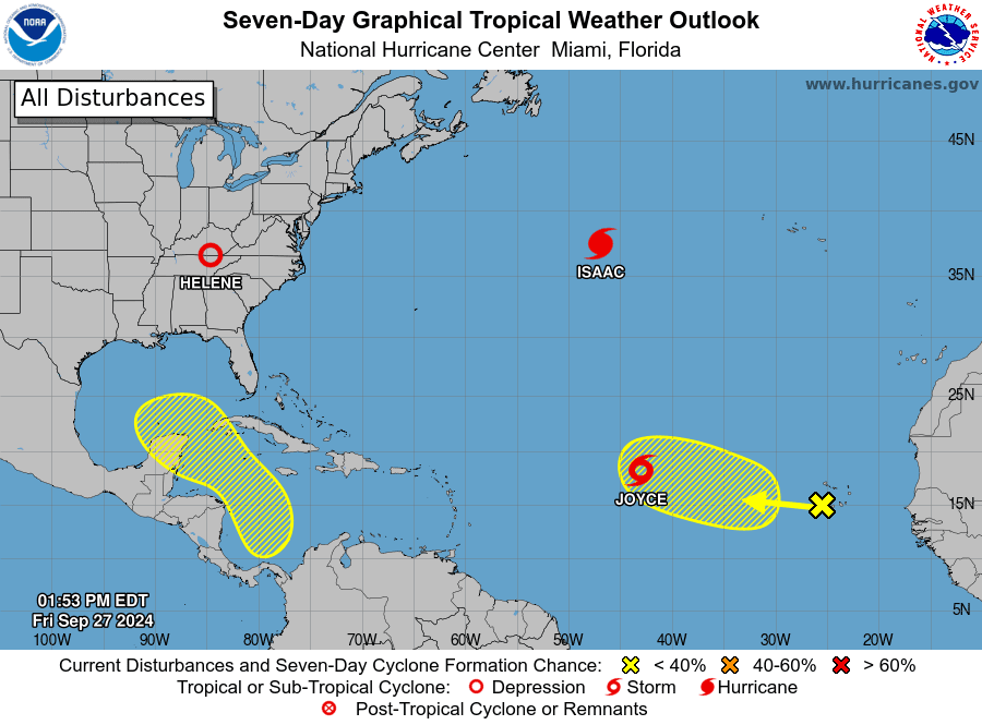
National Hurricane Center forecasters are monitoring Hurricane Isaac, located over the north central Atlantic, and tropical storm Joyce, located over the central tropical Atlantic. Joyce is forecast to turn to the north over the weekend, posing no threat to the Gulf of Mexico. Isaac is forecast to track northeast, to the north of the Azores.
Finally, the National Hurricane Center is also indicating an area of low pressure could form over the eastern tropical Atlantic by the early to middle part of next week. Environmental conditions are expected to be conducive for slow development thereafter while the system moves generally northwestward at 10 to 15 mph. NHC is currently giving this system odds of 20 percent for development over the next seven days.
Have a great weekend!
Bob
Social Media