A Slight Chance for Rain Tuesday and Wednesday. Temperatures Trending Less Hot
SEPT. 23, 2024
Some changes in the late summer weather pattern will be taking place this week, thanks to the stubborn heat dome finally moving to the east. This will allow for a weak cold front to sink south through our area. While true fall-like temperatures are not forecast, readings will be less hot than what we’ve seen lately. This week’s cold front is forecast to cause a few showers and thunderstorms, but no widespread or heavy rain is expected across Central Texas or the coastal plains regions.
As of early Monday afternoon, a weak cold front had pushed southeast out of Northwest Texas and stretched from Waco, to Mason, to Ozona. The cold front, in combination with a trough of low pressure across West Texas, caused the development of showers and thunderstorms across parts of West Texas and the northern Hill Country Sunday night into Monday morning. Some of the heaviest rain fell over the area between Abilene and Brownwood, where totals of 2-5 inches were recorded. A couple of LCRA Hydromet gauges located in northern Brown County both measured just over 5 inches or fain. Significantly lower totals were noted further south over the area between San Saba, Mason, and Eldorado. Radar early Monday afternoon showed much of the rain from overnight had diminished as forcing from a passing trough of low pressure was moving off to the northeast. Forecasts call for the cold front to sag a little further southeast into the Hill Country this afternoon and tonight, pulling up stationary near or just northwest of Austin on Tuesday.
The forecast for Monday afternoon, Monday night and Tuesday afternoon calls for a 20-30 percent chance for scattered rain showers and thunderstorms across the Hill Country and Central Texas regions due to the proximity of the cold front. No widespread or heavy rain is predicted due to the lack of a significant trigger. Rain amounts through Tuesday afternoon are forecast to generally stay below a quarter inch. Across the coastal plains region, forecasts call for a 30-40 percent chance for scattered rain showers and thunderstorms Monday afternoon through Tuesday afternoon as tropical moisture spreads inland from the Gulf. Spotty totals up to a half inch are forecast.
- High temperatures Monday will range from the low 80s across the northern Hill Country, to the low 90s across Central Texas and the coastal plains
- Lows Tuesday morning will range from the mid and upper 60s across the Hill Country, to the low and mid-70s across Central Texas and coastal regions
- High temperatures Tuesday will include the upper 80s across the Hill Country, with low 90s expected at most other locations
- Lows Wednesday morning will range from the mid-60s across the Hill Country, to the low 70s across the coastal plains
A second trough of low pressure is predicted to push east-northeast out of West Texas Tuesday night. The trough will help push a somewhat stronger cold front across the region Tuesday night into Wednesday afternoon. Conditions appear somewhat favorable for the development of scattered rain showers and thunderstorms ahead of and along the cold front Tuesday night into Wednesday. The probability for rain looks to be near 40 percent across the region. However, rain amounts through Wednesday afternoon are forecast to only average around a quarter inch, with a few isolated heavier totals. The rain should taper off from west to east Wednesday afternoon as drier and more stable air spreads in behind the cold front.
Sunny, dry, and slightly cooler weather is forecast late week and through the weekend in the wake of Wednesday’s cold front.
- High temperatures Thursday through Saturday will include the upper 80s across the Hill Country, and the upper 80s to low 90s across Central Texas and the coastal plains
- Lows Friday through Sunday mornings will include the low 60s across the Hill Country, the mid-60s across Central Texas, and the upper 60s across the coastal plains
Looking ahead to next week, sunny and dry weather is predicted the entire week as a weak ridge of high pressure spreads over Texas out of northern Mexico. Temperatures will trend warmer, with highs in the mid-90s, and lows in the upper 60s to low 70s.
Tropical Weather Update
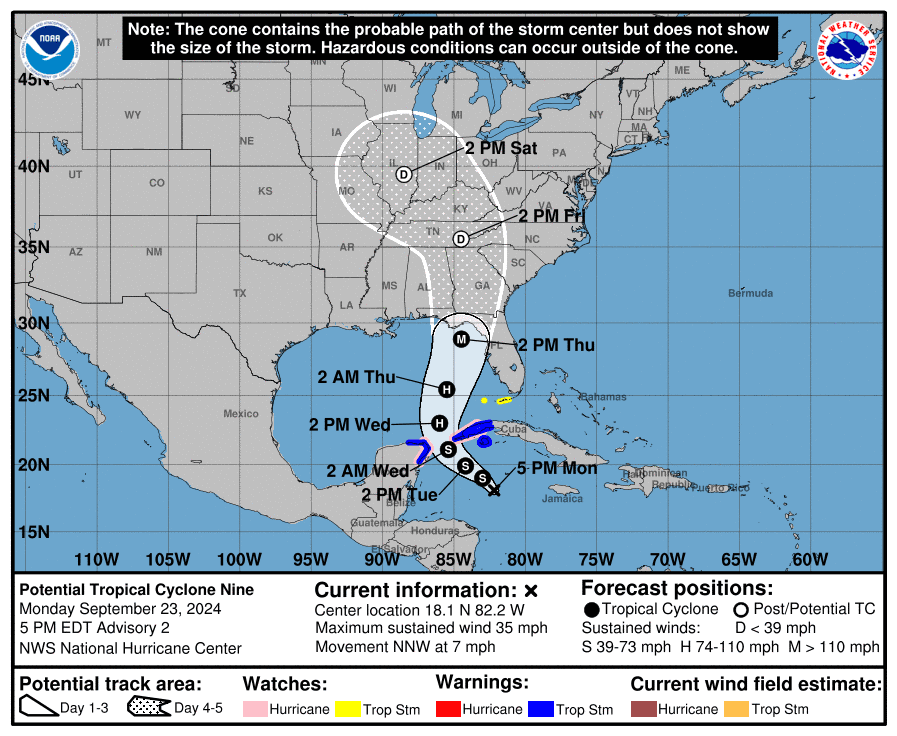
A broad area of low pressure centered over the northwestern Caribbean Sea, to the southwest of the Cayman Islands, continues to produce disorganized showers and thunderstorms across the area. While the system is currently broad and not well organized, the forecast model solutions suggest a more well-defined center should develop during the next day or so. Once the system becomes better organized and develops an inner core, the environmental and oceanic conditions appear favorable for significant strengthening and the system has a high chance for tropical cyclone development. In fact, some of the statistical guidance shows a 95 percent chance of a 65-kt increase in intensity during the next 72 hours, and the hurricane regional models highlight the potential for strengthening to major hurricane intensity! Because of the high likelihood for tropical development, the system has been designated Potential Tropical Cyclone Nine.
A ridge of high pressure to the east of Florida and a developing area of low pressure over the southern plains and Mississippi Valley are expected to steer the disturbance northward over the eastern Gulf of Mexico, bringing the system inland over a portion of the Florida panhandle, the Florida Big Bend area, or the west coast of Florida as early as Thursday. It’s interesting to note there is little spread in the major forecast model solutions.
Based on the latest forecast track, the system poses no threat to the Texas coast.
Once the disturbance enters the Gulf of Mexico, the system will quickly approach the U.S. Gulf coast, with a shorter than usual window for preparations.
Have a good week.
Bob
Social Media