A quick update on recent developments in the Gulf of Mexico.
National Hurricane Center forecasters are closely monitoring a large area of clouds and disorganized showers and thunderstorms over the southwestern Gulf of Mexico associated with a tropical wave and an elongated area of surface low pressure. Satellite-derived winds show this system does not yet have a well-defined center, but is producing winds of 40 to 45 mph on its western side. According to the Hurricane Center, environmental conditions appear conducive for additional development and a tropical storm is expected to form over this general area during the next day or so. NHC is giving this system a 90 percent chance for tropical development over the next couple of days.

NOAA/Colorado State University/RAMMB 09/08/2024 12:30 pm CDT
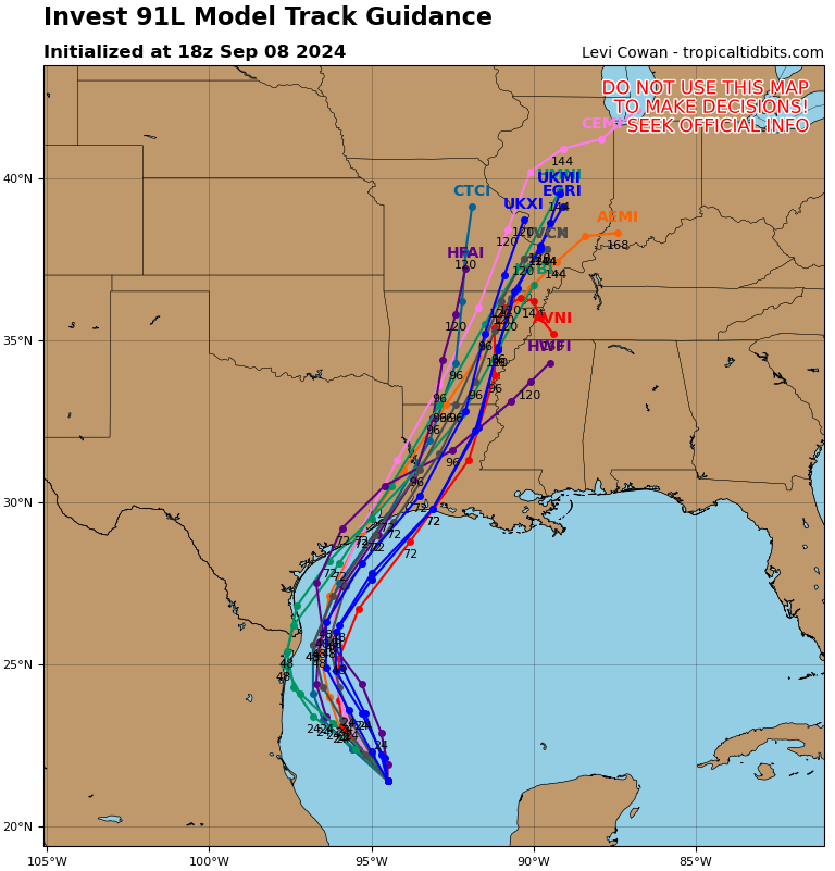
Forecasts call for an area of high pressure to strengthen over the eastern Gulf of Mexico the next couple of days, helping to create a south-southeast to north-northwesterly steering flow over the southwest and western Gulf of Mexico. This is expected to help pull the tropical disturbance toward the western Gulf of Mexico. Over the next few days, the system is forecast to track to the northwest, then northward near or along the Gulf coast of Mexico, and upper Texas and Louisiana coasts.
Much of the latest forecast guidance brings this system into the range of a moderate to possibly strong tropical storm by mid week. Conditions over the southern and western Gulf are generally favorable for development, but the dry air currently in place across Texas may limit the intensity of the system.
While there is much uncertainty in the eventual track of this system, this morning’s suite of computer-forecast solutions showed fairly good agreement for the center of the tropical system to track just offshore of the middle Texas coast some time around Wednesday, then skirting or remaining just off the upper Texas coast late week. But I will caution it is still early and these are just model forecast solutions. The track could end up being closer to the middle Texas coast, or further inland. Track uncertainty will remain fairly high until forecasters and the models are able to establish a more organized and coherent system.
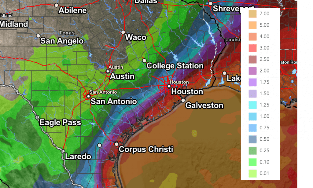
With the current track uncertainty, it is also leading to uncertainty in the forecast for rainfall. A path inland would likely bring a better chance for rain to much of Central Texas, while a path off the coast would lead to little or no rain for Central Texas. It will also affect the totals of rain across the coastal plains. The Weather Prediction Center’s rainfall forecast from midday Sunday calls for the highest amounts of rain to be across the coastal plains, to the south of Interstate 10, where totals of 2 to 4 inches will be possible. Across Central Texas and parts of the Hill Country, totals are predicted to stay quite low.
NWS Rainfall Forecast Valid through 7 pm next Sunday:
I will again caution there is still much uncertainty in the forecast until we can get a better handle on this developing system. I urge everyone to keep up with later updates and forecasts.
Bob
Social Media