A small taste of some fall-like weather is forecast across the region this weekend and early next week as a cold front pushes all the way south into the Gulf of Mexico. Lows Sunday through Tuesday morning are predicted to be in the upper 50s to low 60s. But before we see this change in the weather, there will be more clouds along with a slight chance for showers Friday afternoon and Friday evening.
Friday’s weather maps showed a broad area of low pressure in the middle and upper atmosphere centered just off the middle and upper Texas coast. This is the same low that has been over the area for the past week. Forecasts call for the low to finally begin moving off to the south Friday night into Saturday while it merges with the approaching cold front . Similar to what we saw on Thursday, the counterclockwise circulation around the low is expected to push clouds and abundant moisture from northeast to southwest across the eastern half of the state throughout the afternoon. As temperatures warm Friday afternoon, there will be a 20 percent chance for scattered rain showers and isolated thunderstorms across the Hill Country and Central Texas regions. Heavy rain is not expected. For locations that do see rain, totals are forecast to stay below a quarter inch. Expect a northerly wind at 10-20 mph, with occasional gusts to 30 mph.
For the middle Texas coast, there will be a somewhat better chance for scattered rain showers and thunderstorms Friday afternoon and Friday evening due to the area’s closer proximity to the low. The probability for rain will be near 40 percent. The threat for excessive rain and localized flooding appears to have ended. Totals through Friday evening are forecast to average around a quarter inch. Expect a northerly wind at 10-20 mph, with occasional gusts to 30 mph.
All of the shower activity is forecast to diminish Friday evening.
A cold front is predicted to push south across the region Saturday morning into Saturday afternoon, ushering in slightly cooler and noticeably drier air. After a long summer, this air should feel quite refreshing! The front is expected to reinforce the gusty northerly winds already in place. Forecasts call for northerly winds with speeds of 10-20 mph, and gusts to 25/30 mph Saturday through Sunday. No rain is expected with the front. The sky will be sunny Saturday through Monday.
- High temperatures Saturday and Sunday are predicted to generally be in the middle 80s, warming to the upper 80s Monday
- Lows Sunday and Monday mornings will range from the mid and upper 50s across the Hill Country, to the upper 50s to low 60s across Central Texas, to the mid to upper 60s across the coastal plains
- Lows Tuesday morning are forecast to be mostly in the low and mid-60s, with upper 60s to low 70s near the coast
Next Week
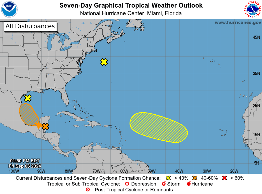
The sunny and fall-like weather pattern is forecast to come to a fairly abrupt end Tuesday as of southerly breezes bring a return of warm and humid air. A somewhat complex weather pattern looks to take shape over the western Gulf of Mexico next week, with this weekend’s cold front stalling over the northwestern Gulf of Mexico. At the same time, a tropical wave currently located over the western Caribbean Sea is predicted to track to the northwestern Gulf and merge with the stalled cold front. Circulation around the tropical wave is expected bring a surge of clouds and tropical moisture from the coast, north into Central Texas and the Hill Country beginning Tuesday, continuing through late week. There is quite a bit of uncertainty as to just how the pattern will evolve. The National Hurricane Center indicates the tropical wave over the Yucatan Peninsula and Belize could develop into a tropical depression and be situated somewhere over the southwestern or western Gulf of Mexico during the early or middle part of next week. Depending on the track and speed of the system, it could bring heavy rain to parts of the middle Texas coast.
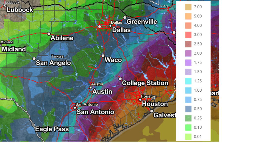
The chance for rain and thunderstorms is forecast to increase across the coastal area Tuesday and across the rest of the region Wednesday trough Friday. The National Weather Service’s rainfall forecast through 7 pm next Friday calls for totals of at least 1-2 inches for locations east of Interstate 35. Considerably higher totals are forecast for areas close to coast.
High temperatures next week are forecast to generally be near 88-90 degrees.
NWS Rainfall Forecast for the Period 7 am Friday through 7 am Next Friday:

Tropical Weather Outlook
National Hurricane Center forecasters are monitoring tropical waves over the northwestern Atlantic, the central tropical Atlantic, and the northwestern Caribbean Sea/Gulf of Mexico, The northwest and eastern Atlantic systems have both been given just a slight chance for tropical development over the next 5 to 7 days.
Of special interest is the tropical wave located over Belize and the Yucatan Peninsula of Mexico. This system is producing a disorganized area showers and thunderstorms. Forecasters call for the wave to move into the Bay of Campeche on Saturday, where it could begin to interact with a frontal boundary. A tropical depression could form during the early or middle part of next week while the system moves slowly northwestward over the southwestern Gulf of Mexico. NHC forecasters are giving this system a 40 percent chance for tropical development over the next seven days.

Have a great weekend!
Bob


Social Media