Tropical Moisture to Bring a Chance for Rain through Labor Day Weekend
AUG. 27, 2024
As we close out the month of August, the weather pattern looks to feature periods of rain with temperatures less hot from what we’ve seen lately. This pattern change is occurring as the center of the heat dome has shifted northeast up to the Tennessee and Ohio Valley regions. With the heat well up to our north, it has allowed a non-tropical area of low pressure to back west into Central Texas out of the Gulf of Mexico. Tuesday’s analysis showed the low centered over the Texas Hill Country. A counterclockwise flow around the low is helping to pull considerable tropical moisture inland all the way west to the Edwards Plateau region. Forecasts call for the low pressure system to slowly shift further to the west Wednesday, then become diffuse Thursday into Friday.
Tuesday afternoon through Wednesday, expect a 30-40 percent chance for scattered rain showers and thunderstorms across the region as moisture continues to spread northwest from the coast. The most favorable period for rain will be in the afternoon and early evening periods. The severe storm threat will be quite low, but some of the stronger storms will be capable of producing gusty winds, brief heavy rain, and dangerous lightning.
For areas that do see rain, amounts both days are forecast to average between 0.25 and 0.5 inches, with isolated totals of 1-2 inches possible. High temperatures both days are predicted to be near 90-92 degrees.
The outlook for Thursday and Friday calls for a 20-30 percent chance for mainly afternoon and evening scattered rain showers and thunderstorms across the Hill Country and Central Texas regions as tropical moisture remains in place across the area. Spotty rain amounts of a quarter inch and less are forecast. There will be a 60-70 percent chance for scattered rain showers and thunderstorms across the coastal region due to a zone of increased tropical moisture. Rain amounts are forecast to average between a quarter and a half inch, with isolated totals of 1-2 inches possible. High temperatures both days are predicted to be in the low and mid-90s.
For Saturday through Labor Day, expect an increased coverage of rain showers and thunderstorms across the entire region as a weak cold front sags southeast out of Northwest Texas. At the same time, a new low pressure system is predicted to push west out of the Gulf of Mexico, pulling tropical moisture north from the coast. The two features are expected to cause a 50-60 percent chance for mainly afternoon and evening showers and thunderstorms across the Hill Country and Central Texas regions, and a 70-80 percent chance for rain and thunderstorms across the coastal region. Daily rain amounts are forecast to generally average between a quarter and a half inch, with isolated totals to near 2 inches possible. Do note some pockets of locally heavy rain may develop from some of the slower-moving storm cells.
Expect a partly cloudy to mostly cloudy sky each day, with high temperatures generally in the low 90s.
Looking out into next week, forecasts call for a daily chance for rain showers and thunderstorms to continue as the moist flow off the Gulf persists and the heat dome remains off to our west and east. There are some indications for heavier rains developing next Wednesday and Thursday. High temperatures next week are predicted to generally be around 88-90 degrees.
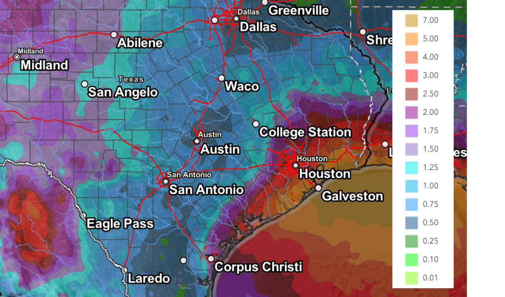
Total rain amounts through early next week are forecast to highest across the coastal area and the Edwards Plateau/western Hill Country regions, and lowest across the Interstate 35 corridor. According to the Weather Prediction Center, totals of 2-5 inches will be possible across Wharton and Matagorda Counties.
NWS Rainfall Forecast for the Period 7 pm Tuesday through7 pm Next Tuesday:

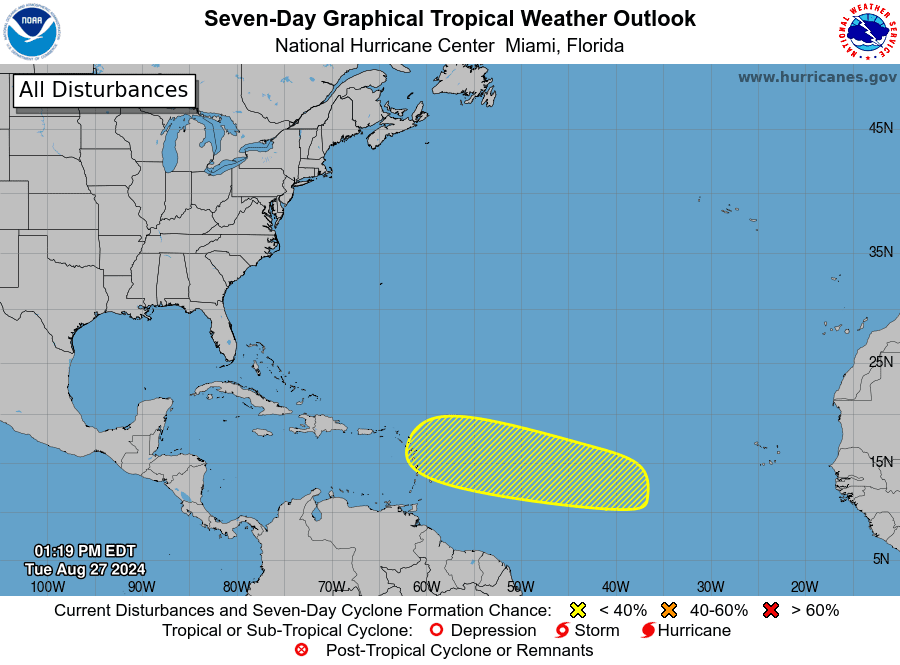
Tropical Weather Outlook
National Hurricane Center forecasters are indicating an area of low pressure could form in the central portion of the tropical Atlantic over the few days. If a low does develop, environmental conditions appear generally favorable for some slow development of this system this weekend into early next week as the system moves westward to west-northwestward at 10 to 15 mph.

Elsewhere, conditions are quiet and tropical cyclone development is not expected over the next 5-7 days.
Bob


Social Media