This week has provided a nice break from the typical weather we normally see in late July. Last year at this time, Austin was in the middle of a 45-day streak of consecutive triple digit temperatures that didn’t break until August 22nd. To make matters worse, only 0.01 inches of rain was recorded during this 45-day stretch. This July, rainfall is averaging above normal at all locations.
This week’s unusual pattern of less hot weather and scattered rains is expected to continue through Sunday. A trough of low pressure in the middle and upper atmosphere currently stretching from southwest Texas, to the Ohio Valley is forecast to remain stalled over the area through Sunday. Rising air on the eastern side of the trough is expected to cause the development of scattered showers and thunderstorms—mainly in the late morning trough evening periods. The most favorable area for widespread rain and thunderstorm development is predicted to be across the middle and upper Texas coast, extending inland to around Intestate 10. Isolated to scattered rain showers and thunderstorms are forecast across Central Texas and the eastern counties of the Hill Country.
The probability for rain Friday afternoon, Saturday, and Sunday will be near 30 percent across the eastern Hill Country. Across Central Texas, the probability for rain will be near 40-50 percent. For the middle Texas coast, the probability for rain will be at 70 percent.
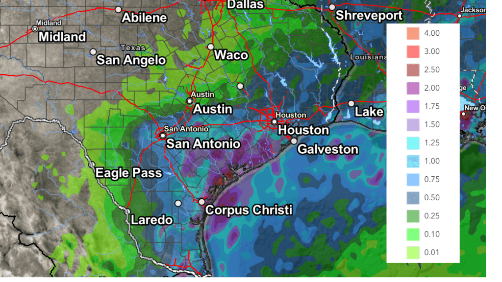
Daily rain amounts should average well below a quarter inch across the eastern Hill Country, and close to a quarter inch across Central Texas. Across the middle Texas coast, daily rain amounts of 0.5 to 1 inch are forecast, with isolated higher totals of 2-3 inches.
Cumulative rain amounts through Monday evening are forecast to average around a quarter inch or less across the eastern Hill Country, be between 0.25 and 1.5 inches across Central Texas, and total between 1.5 and 2 inches across the middle Texas coast. Isolated heavier totals to near 5 inches will be possible.
NWS Rainfall Forecast Valid through 7 pm Monday:

Plenty of clouds under the broad upper trough will help to keep afternoon temperatures below seasonal normals through the weekend. (Normal high temperatures for late July are in the upper 90s). Daily high temperatures are forecast to be near 88-90 degrees across the Hill Country and Central Texas. For the coastal plains, highs are forecast to be in the low and mid-80s. Unfortunately, it will still feel hot thanks to the high humidity levels and relatively light winds.
The outlook for next week calls for a return to more typical late July/early August weather conditions as the stalled upper trough over Texas finally lifts off to the northeast. In it’s place, the large heat dome over the western U.S. is predicted to spread back across Texas. Fortunately, the center of the heat dome is forecast to remain over the Four Corners region and not spread over Texas. Mostly sunny, dry and warmer weather is forecast throughout the week.
- High temperatures Monday and Tuesday are forecast to be in the low to mid-90s across the Hill Country and Central Texas regions, and in the low 90s towards the coast
- High temperatures Wednesday through next weekend are forecast to be in the mid to upper 90s across the Hill Country and Central Texas regions, but remain in the low 90s across the coastal plains
Long-range forecasts hint the next chance for rain will take shape the week of August 5th, when the heat dome shifts away from Texas and back to the western U.S.
Tropical Weather Outlook
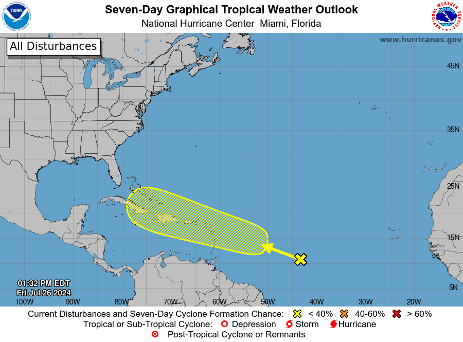
National Hurricane Center forecasters are monitoring an area of disturbed weather located over the central tropical Atlantic Ocean. The clouds and showers are expected to interact with an approaching tropical wave during the next several days. Some tropical development of this system will be possible while it approaches the Lesser Antilles during the early to middle part of next week. The system is forecast to move generally west-northwestward near the Greater Antilles toward the latter part of next week.
As of now, NHC forecasters are giving this system just a low chance (20 percent chance) for tropical development over the next seven days.

Catch a View of the ISS this Weekend and Next Week
There will be several opportunities to see the International Space Station travel across our sky over the next few evenings. The best one looks to be Sunday evening, when the station will reach a point 68 degrees above the northern horizon. In the Austin area, that particular pass will occur at 10:13 pm.
You can find out more specifics about the upcoming passes from NASA’s website Spot The Station | NASA Just input your city and click on the big blue marker to get all of the details.
Have a great weekend!
Bob


Social Media