What a week it’s been with the weather! The rainy pattern which started last Monday, hung around all the way through Sunday. Looking back at rain totals over the past week from LCRA’s Hydromet, the highest totals occurred across Wharton, Matagorda, Kimble, and Edwards Counties, were 7 to nearly 10 inches of rain were recorded. Much of Central Texas received between 2 and 5 inches, while totals across the northern Hill Country varied between a tenth of an inch, and nearly 5 inches!
Unfortunately, the pattern which caused the rain and more tolerable temperatures has come to an end. Monday’s weather maps showed the trough of low pressure which had been in place across Texas all of last week has been replaced by a strengthening ridge of high pressure, or heat dome. The heat dome is currently centered over the central Gulf of Mexico. Forecasts call for the center of the heat dome to spread to the northwest this week, moving across East Texas mid-week, arriving across the central and southern Rockies this weekend. A sunny to mostly sunny sky can be expected throughout the week.
As the heat dome spreads over Central and South Texas, the chances for additional rain will decrease dramatically. While a couple of spotty rain showers will be possible for coastal locations this afternoon and again Tuesday afternoon, dry conditions are forecast region-wide through Saturday.
With few clouds and no rain, temperatures will trend warmer this week, continuing into the weekend.
- High temperatures Monday and Tuesday are forecast to be in the mid-90s across the Hill Country and Central Texas regions, and in the low 90s across the coastal plains
- High temperatures Wednesday through Saturday are forecast to be in the upper 90s to 100 degrees across the Hill Country and Central Texas regions, while lower 90s should continue across the coastal plains
High relative humidity levels are expected throughout the week, causing peak heat index readings of 103-109 degrees each day.
Looking ahead to Sunday and next week, forecasts call for the center of the heat dome to shift a little further to the north, away from Texas. This more northern position away from Central Texas may open the door for a few spotty afternoon rain showers across the region next week next week. But note that widespread or heavy rain is not expected. High temperatures are forecast to generally be in the upper 90s, possibly trending down a couple degrees the second half of the week.
Tropical Weather Outlook
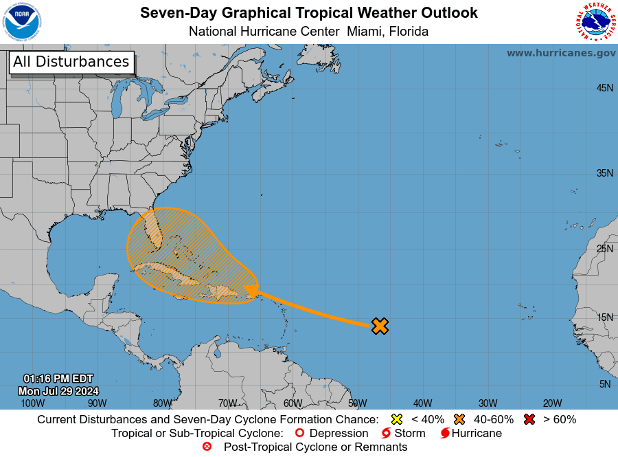
National Hurricane Center forecasters are keeping a close watch on an area of disturbed weather located over the central tropical Atlantic Ocean. This system is expected interact with an approaching tropical wave during the next day or two. Environmental conditions are forecast to become conducive for gradual development thereafter, and a tropical depression could form late this week while the system is in the vicinity of the Greater Antilles or the Bahamas.
NHC forecasters are giving this system a medium chance (a 50 percent chance) for tropical development over the next seven days.

Elsewhere, weather conditions are quiet and tropical development is not expected over the next seven days.
Saharan Dust Arriving Monday Evening
A plume of Saharan dust is predicted to reach the region Monday evening and remain over the area through late week. The dust is expected to cause an increase in fine particulate levels and result in a hazy-looking sky throughout the week.
Have a good week!
Bob


Social Media