Rain showers and scattered thunderstorms have continued across the region today, although areal coverage has been less than the past couple of days. As of 2 pm, LCRA’s Hydromet showed the showers have produced spotty totals of 1-2 inches across parts of Central Texas. Heavier and more concentrated rains have fallen across the middle Texas coast, producing totals of 1-3 inches across Wharton and Matagorda Counties.
Thursday’s analysis showed a trough of low pressure in the upper atmosphere stretching from the southern Great Lakes to Southwestern Texas, causing a moist and unstable atmosphere across the eastern half of Texas. It’s interesting to note a weak area of low pressure in the lower atmosphere developed across south central Texas Thursday morning. The circulation around this low helped pull tropical moisture inland to Central Texas and the eastern Hill Country. The counterclockwise circulation around this low is expected to cause a 40-50 percent chance for additional rain showers and thunderstorms for the eastern Hill Country, Central Texas, and the middle Texas coast Thursday afternoon into Thursday evening.
While a decrease in shower activity is forecast this evening, high resolution forecasts call for more showers and scattered thunderstorms to develop after midnight for areas along and east of Interstate 35. The rain is forecast to continue into Friday morning. While not a certainty, the model solutions have been fairly consistent in calling for this rain development.
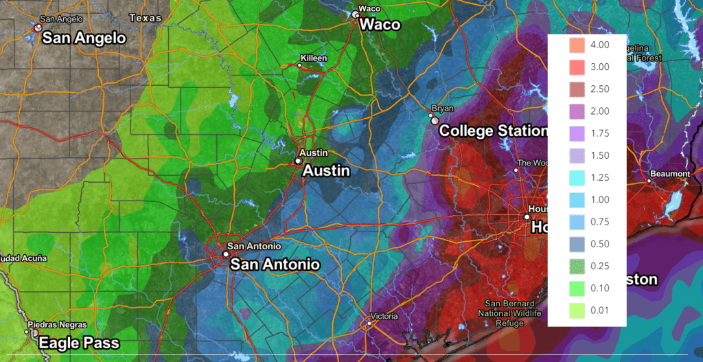
Friday afternoon through Sunday, a chance for mainly afternoon and evening showers and thunderstorms looks to continue for the eastern Hill County, Central Texas, and coastal region as the trough of low pressure remains in place across the region. The chance for rain will range from 30 percent across the eastern Hill Country, to near 40-50 percent across Central Texas, to 70-80 percent across the coastal plains. The rain is expected to be heaviest across the coastal region, with lighter amounts expected further inland. Daily rain amounts are forecast to range from around 1 inch across the coastal plains, to around a quarter inch across the Austin/Interstate 35 corridor.
The Weather Prediction’s Rainfall forecast, for the period Friday through Sunday, calls for cumulative totals of 2-3 inches across the middle Texas coast, 0.5 to 1.25 inches across Central Texas, and around a quarter inch or less across the Hill Country.
NWS Rainfall Forecast Valid through 7 am Monday:

Generally dry and warmer weather is forecast beginning Monday as the western heat dome spreads east to cover most of Texas. High temperatures are forecast to return to the mid and upper 90s. Interestingly, today’s forecasts indicate the heat dome may begin to shift back to the west and northwest next weekend, which could open the door for some additional unsettled weather. Stay tuned.
Bob


Social Media