Our weather looks to be rather unsettled this week thanks to a broad trough of low pressure which has developed and currently stretches from West Texas, to the Middle Mississippi Valley region. Typically in late July, the heat dome covers most of Texas. But recently, the heat dome split, with one dome now covering the western U.S., and the other dome covering the southeastern U.S. This unusual pattern is forecast to persist all week and through the upcoming weekend. Next week, the heat dome is forecast to spread back close to Texas.
Over the next several days, waves of low pressure are forecast to move trough the broad trough and track east across Central and South Texas, causing periods of rain showers and thunderstorms across the region. Monday’s data suggests the most favorable area for rain will slowly begin to shift away from the Hill Country mid-week as the broad trough shifts east out of West Texas. Meanwhile, a good chance for rain showers and thunderstorms is expected to continue across Central and Southeast Texas throughout the week and into the weekend. Towards the coast, a very tropical air has developed and has been instrumental in the development of moderate to heavy rain across parts of the coastal region over the past couple of days. A similar pattern is expected to continue for the next few days.
It should be noted a very moist air mass has spread inland from the Gulf of Mexico to cover most of the region. This very moist air mass, combined with the slow and erratic movement of the storms, means there will be a potential for any of the storms to produce high totals of rain in a relatively short period of time. Most of this week’s rain and storms is expected to occur during the day and into the evening hours as temperatures warm modestly.
Forecasts show a 70-80 percent chance for rain showers and scattered thunderstorms across the entire region Monday afternoon and again on Tuesday. Beginning Wednesday, the probability for rain and storms across the Hill Country and northern counties of Central Texas looks to decrease slightly to 40-50 percent and continue there through the weekend. For the eastern half of Central Texas and the middle Texas coast, the probability for rain will remain near 70-80 percent through the upcoming weekend.
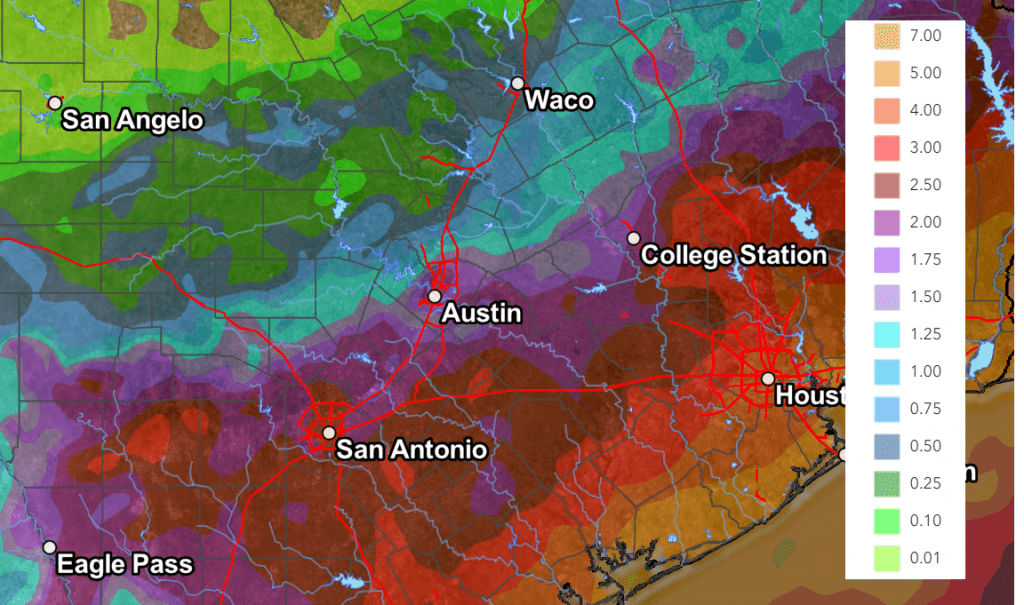
The Weather Prediction Center’s rainfall forecast for the next seven days calls for the highest cumulative totals of rain to occur along and south of a line stretching from Hondo, to Austin, to College Station. For these locations, totals of 2-4 inches, with isolated higher totals are predicted. Areas south of Interstate 10 could see totals of 3-5 inches. For the Hill Country, totals will range from 0.5 to 1 inch across the north, to the 1-2 inches across the southern and eastern areas.
NWS Rainfall Forecast for the Period 7 pm Monday through 7 pm Next Monday:

Drier, but not completely dry, and warmer conditions are forecast next week.
Tropical Weather Outlook
Quite weather conditions continue across the tropical Atlantic and tropical cyclone development is not expected for at least the next seven days.
Bob


Social Media