Here’s my Sunday update on Tropical Storm Beryl.
- A Hurricane Warning is in effect for the Texas coast, from Baffin Bay northward to San Luis Pass, Texas. This includes Matagorda County
- A Tropical Storm Warning is in effect for Fayette, Colorado, and Wharton Counties
- Beryl’s forecast track has shifted a slight amount to the east and is predicted to track inland a bit faster than previous forecasts
- Landfall is expected just before sunrise Monday
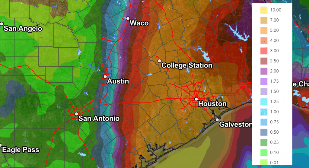
- The heaviest rains of 5-10 inches are now predicted to fall a little further to the east—mainly over the area between Matagorda Bay, College Station, and Tyler
Intensity/Track Discussion
Satellite images and data from a Hurricane Hunter aircraft indicate Tropical Storm Beryl is becoming better organized. Brownsville Doppler radar has been showing an eyewall, although as of late morning, it was still open on the northwest side.
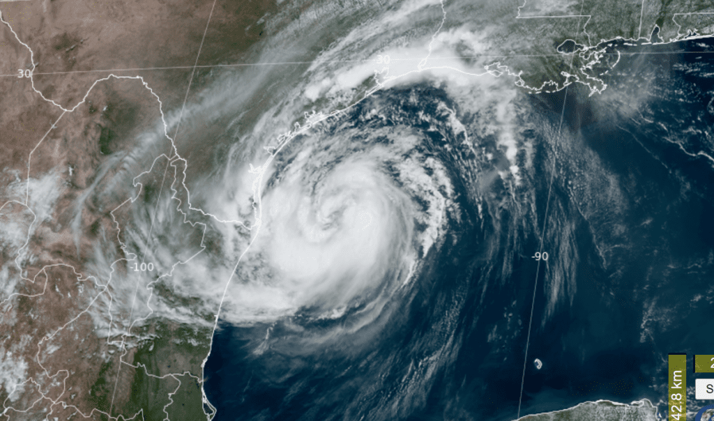
NOAA/Colorado State University/RAMMB 07/07/24 11:50 am CDT
As of 10 am, maximum sustained winds were up to 65 mph. Further intensification is likely as Beryl moves over very warm waters within light shear conditions. Rapid intensification is a distinct possibility if the core can become isolated from the dry air that has been inhibiting intensification during the last day or so. Beryl is predicted to be intensifying right up until landfall early Monday. Forecasts call for maximum sustained winds of 85 mph at the time of landfall.
Beryl is moving northwestward at 10 mph. The storm is forecast to turn north-northwest this afternoon, making landfall along the middle Texas coast, near Matagorda Bay, before sunrise on Monday. NHC’s 10 am updated forecast track has shifted the point of landfall slightly to the east, with the most likely area now expected to be on the eastern side of Matagorda Bay. But do note the cone of uncertainty stretches from Port Aransas, to Freeport.
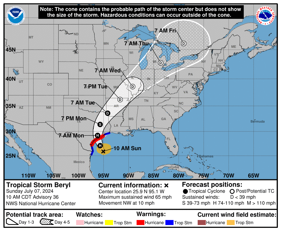
Following landfall, Beryl’s is forecast to turn northward, and eventually northeastward. An increase in forward speed is also forecast Monday into Tuesday. Beryl’s forecast track calls for the center to move over the Wharton/Columbus/Bellville area Monday morning, then move northeast to the Brenham/College station area Monday afternoon, and the Tyler/Northeast Texas area Monday night.
Based on the latest track, it appears the greatest wind and rain impacts from Beryl will occur on Monday over the area generally along and to the east of Highway 77, from Victoria, to La Grange, to Rockdale. Minimal impacts are expected across the Hill Country and the Austin/Interstate 35 corridor.
- A Hurricane warning has been posted for Matagorda County through Monday. A Hurricane Warning means that hurricane conditions are expected somewhere within the warning area. Preparations to protect life and property should be rushed to completion
- A Tropical Storm Warning has been posted for Wharton, Colorado and Fayette Counties through Monday. A Tropical Storm Warning means that tropical storm conditions are expected within the warning area
The first rain band associated with Beryl pushed inland along the coast earlier this morning. Showers and thunderstorms are forecast to increase across the middle Texas coast beginning late this afternoon and continue overnight and through Monday. Strong winds will begin to spread inland Sunday night and continue through Monday morning.
- For Matagorda County, expect wind speeds to increase to 55-65 mph, with gusts to 100 mph after midnight Sunday night. On Monday, expect wind speeds of 60-70 mph, with gusts to 95 mph. Wind speeds should decrease in the afternoon.
- For Wharton County, expect wind speeds of 30-40 mph, with gusts as high as 80 mph after midnight. On Monday, expect wind speeds of 45-55 mph, with gusts as high as 95 mph Monday morning. Wind speeds decrease in the afternoon
- For Colorado County, expect wind speeds of 20-30 mph, with gust to 55 mph after midnight. On Monday, expect wind speeds of 25-35 mph, with gusts to 70 mph
- For Fayette County, expect wind speeds of 15-25 mph, with gusts to 45 mph after midnight. On Monday, expect wind speeds of 20-30 mph, with gust to 55 mph.
- For the Austin/Interstate 35 corridor, expect wind speeds of 15-25 mph, with gusts to 30 mph on Monday
The heaviest rains are predicted to occur along and to the east of the path of Beryl. Updated rainfall forecasts through Tuesday call for totals of 5-10 inches over the area between Matagorda Bay, Bellville, and College Station, with lower totals to the west. Totals will range from 4-5 inches across Fayette County, to between 0.5 and 1 inch across the Austin/Travis County area. Across the Hill Country, most totals are forecast to average less than a half inch.
NWS Rainfall Forecast for the Period 7 am Sunday through7 am Wednesday:
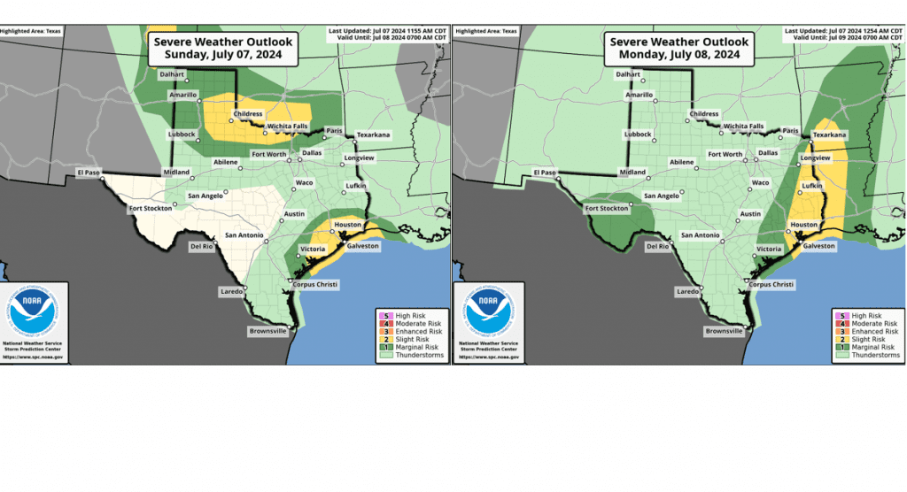
Finally, do keep in mind isolated tornadoes will be possible tonight and Monday for areas along and to the east of the path of Beryl. The Storm Prediction Center has placed Matagorda and Wharton Counties under a Slight Risk for severe thunderstorms through early Monday morning, and a Moderate risk for severe thunderstorms during the day on Monday.
Bob
Social Media