Watching for Potential Tropical Development Next Week
June 12, 2024
The National Hurricane Center is monitoring the potential for a broad area of surface low pressure to possibly develop into a tropical cyclone in the Bay of Campeche late in the weekend or early next week. Should such a system develop, it is forecast to move slowly westward or west-northwestward toward the northern Mexican or southern Texas coast.
Computer forecast solutions indicate a trough axis will move into the central and western Gulf of Mexico late this weekend into early next week. There is some consensus among the solutions for some sort of surface low pressure area to form in the Bay of Campeche or southwestern Gulf of Mexico. Environmental conditions are forecast to be somewhat favorable for tropical cyclone formation over this area next week, with low wind shear and a moist atmosphere. A building ridge of high pressure over the Southeastern U.S. would help to steer any potential system to the west or west-northwest.
NHC forecasters are currently giving this system a low chance (20 percent chance) for tropical cyclone development over the next 7 days.
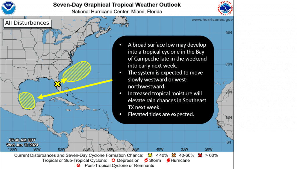
As of right now, it’s way too early to know what impacts this system could have on our region. We’ll begin to get a better handle this over the next few days once the system starts to develop. For now, the main impacts from this system are expected to be felt along and just inland of the Texas coast as increasing tropical moisture will cause elevated rain chances during the early and middle parts of next week. Also, expect elevated tides.
The National Weather Service rainfall forecast for next Monday and Tuesday calls for general totals of 1-3 inches for the middle and upper Texas coast.
NWS Rainfall Forecast for the Period 6 am Monday through 6 am Wednesday:

Stay tuned for additional updates.
Bob
Social Media