A quite, summer-like weather pattern is returning to the region following the area of clouds and rain that spread south on Wednesday. This summer-like pattern is forecast to continue through the weekend. Thursday’s weather maps showed a large ridge of high pressure, or heat dome, stretching from northern Mexico up to the Pacific Northwest. Forecasts call for the heat dome to weaken slightly while it shifts east across Texas over the next 2-3 days. Weather conditions as result, will remain sunny, dry, and hot through Sunday afternoon. East and southeasterly breezes with speeds of just 5-10 mph are predicted through Friday. Wind speeds look to increase to a range of 10-15 mph on Saturday and Sunday.
- High temperatures Thursday afternoon through Sunday are predicted to be in the upper 90s across the Hill Country and Central Texas regions, and in the mid-90s across the coastal plains
- Low temperatures are predicted to generally be in the low and mid-70s
A brief change in the weather pattern is forecast to take place early next week when the heat dome slides southeast over the Gulf of Mexico, opening the door for a short-lived period of more active weather Monday into Tuesday. A deep trough of low pressure over the Great Lakes region will help push a weak cold front south into Texas. The front is forecast to push south out of North Texas Sunday night, reaching the Interstate 10 corridor and stalling out sometime Monday morning. The cold front will bring a 30-40 percent chance for scattered rain showers and isolated thunderstorms to the Hill Country and the Interstate 35 corridor Sunday night, and to the entire region on Monday. A 20 percent chance for scattered rain showers will linger into Tuesday. The chance for rain will diminish beginning Tuesday afternoon as the heat reestablishes across northern Mexico.
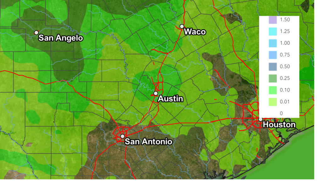
Severe storms appear unlikely during this upcoming period. And rain amounts are not expected to be very high. Forecasts call for totals of 0.25 to 0.5 inches across much of the Hill Country, with totaling less than a quarter inch at most other locations.
NWS Rainfall Outlook for the Period 7 pm Thursday through 7 pm Next Thursday:
High temperatures Monday and Tuesday are predicted to be around 90-92 degrees.
The outlook for the middle and latter part of next week calls for a return to sunny and hot weather across the region as the heat dome sets up across northern Mexico and the Desert Southwest. High temperatures are forecast to be in the mid and upper 90s, with lows in the mid-70s.
Long-range outlooks show little change next weekend. There are some indications a slight chance for rain will return to the forecast during the early and middle parts of the week of the 17th.
Tropical Weather Outlook
Weather conditions are quiet across the tropical Atlantic and tropical storm development is not expected over the next seven days.
Stay cool and hydrated!
Bob
Social Media