Memorial Day weekend has oftentimes brought heavy rain and flooding to much of the area. While a few showers and thunderstorms are forecast over the next three days, the chances for heavy rain and flooding this Memorial Day weekend appear quite low. Interestingly, the biggest weather threats this year will likely be the extreme heat and high humidity Some of the hottest temperatures so far this year are forecast for Sunday and Memorial Day. Fortunately, this early season heatwave is expected to be short-lived and temperatures should moderate beginning Tuesday.
On this Friday, scattered late afternoon and evening thunderstorms will once again be possible across the northern Hill Country and the northern counties of Central Texas, including the Austin metro. High resolution forecasts indicate scattered thunderstorms will have some potential to develop along the dry line over the area between Brownwood, Brady, and Mason late this afternoon, with the storms then tracking east-southeast to the Interstate 35 corridor between San Marcos, Waco, and Dallas. The probability for thunderstorm development over this area will only be 20-30 percent. However, should thunderstorms develop, the atmosphere will easily support severe convection with large hail and damaging winds. The Storm Prediction Center has placed the eastern/northern Hill Country and the northern counties of Central Texas in a Slight Risk, or 2 out of 5 risk, for severe thunderstorms through Friday night.
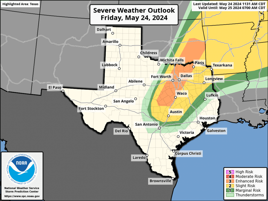
Rainfall from Friday’s scattered storms will be spotty, with totals to near 1 inch possible.
For most of the area, Friday’s weather will be mostly sunny and hot with high temperatures in the low and mid-90s. Expect a south breeze at 10-15 mph, with gusts to 20 mph.
For Saturday through Sunday, no rain or thunderstorms are forecast across the region. A stable ridge of high pressure or heat dome, is predicted to build north across Texas out of Mexico. The ridge is expected to cause a pattern of sunny, humid, and hot weather both days. A southerly breeze at 10-15 mph is forecast both days.
- High temperatures across the Hill Country and Central Texas regions are forecast to be in the mid-90s Saturday, warming to the upper 90s on Sunday. Coastal locations can expect mid-90s both days
Figuring in the high humidity level, peak heat index readings of 105-110 degrees are predicted for both days.
For anyone traveling to the middle Texas coast Friday and through the weekend, coastal hazards will also be noteworthy. A high risk for rip currents, above normal water levels, and above normal surf can be expected. If at the beach, it is advised to swim near a lifeguard and away from rocks, jetties, and piers.
Memorial Day is shaping up to be mostly sunny and quite hot across the region! High temperatures of 98 to 100 degrees are forecast across the Hill Country and Central Texas regions, and upper 90s across the coastal plains. While the heat will be the biggest story, there will also be a 20-30 percent chance for scattered late afternoon and evening rain showers and thunderstorms across the northern counties of the Hill Country and Central Texas, including the Austin metro. Forecasts call for a weak cold front to sag south out of North Texas late Monday into Monday night. The front is predicted to stall across the coastal plains region Tuesday. Spotty rain amounts of 0.25 to 0.5 inches will be possible.
Looking ahead to next Tuesday through Friday, forecast solutions are showing the development of a somewhat unsettled weather pattern. The heat dome that will build north across Texas this weekend is forecast to slowly retreat south toward Mexico. Meanwhile, forecasts call for a couple of troughs of low pressure to move across the northern half of Texas. This will result in a 30-40 percent chance for scattered rain showers and thunderstorms across the region between Tuesday evening and next Friday. Rain amounts over this period are predicted to be close to an inch, possibly higher.
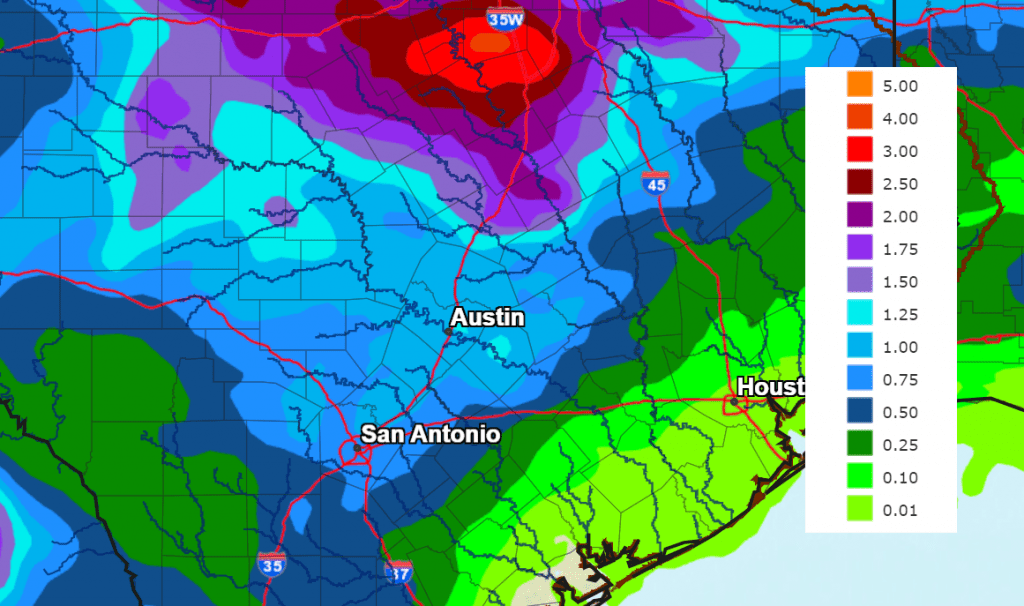
NWS Rainfall Forecast for the Period 7 pm Friday through 7 pm Next Friday:
High temperatures next Tuesday through Friday are forecast to generally be in the low 90s, with lows in the low and mid-70s.
Tropical Weather Outlook
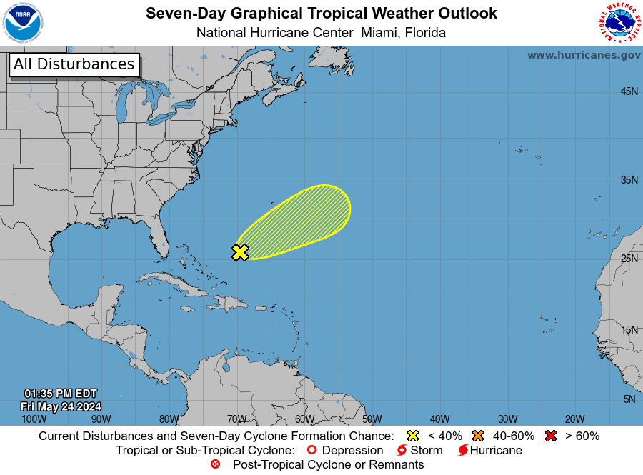
National Hurricane Center forecasters are monitoring a trough of low pressure that is producing disorganized showers and thunderstorms a few hundred miles to the northeast of the central Bahamas. They note an area of low pressure is expected to form within this system roughly halfway between Bermuda and Hispaniola late Friday. Although environmental conditions are not conducive, some slight subtropical or tropical development will be possible over the next couple of days while the system moves northeastward over the area east of Bermuda.
NHC forecasters are giving this system a low chance (10 percent chance) for tropical development over the next seven days.
Only Two Planets Currently Visible
There are currently only two planets visible in the night sky, and can only be seen in early dawn. The highest and easiest to view is Saturn, in the southeastern sky. Look for Mars far lower left of Saturn, by roughly three fists at arm’s length. It’s at magnitude 1.1, and again, nothing else there is as bright.
Mercury, Venus, Jupiter, Uranus, and Neptune are all currently veiled by the Sun’s glare and not visible.
I hope everyone has a safe, relaxing, and meaningful holiday weekend. If you’re planning outdoor activities, which I know many are, please dress lightly, stay hydrated, and have shade or A/C available to take breaks in and to keep yourself cooled down. Avoid strenuous activity during the hottest part of the day, and look before you lock your car. And remember that if the ground is too hot for the palm of your hand, it is too hot for your pets’ paws.
Bob
Social Media