We’re looking at the potential for some active and potentially severe storms across the northern Hill Country, possibly extending as far south and east as the Austin area, this afternoon and again late tonight into early Friday morning.
As of midday Thursday, Doppler radar showed a few scattered thunderstorms tracking northeast across the Hill Country, between Junction, Mason, and Brady. Additional showers and isolated thunderstorms were occurring to the west and northwest of Austin.
Today’s activity is being generated by a small wave of low pressure moving northeast out of West Texas. High resolution forecasts call for additional scattered showers and thunderstorm to develop across the Hill Country and the Interstate 35 corridor this afternoon as the wave of low pressure lifts to the northeast. The probability for rain will range from around 70 percent across the northern half of the Hill Country, to around 30 percent along the Austin/Interstate 35 corridor, to just 20 percent in the La Grange/Columbus area.
Due to the way today’s atmosphere is structured, there will be a low-end chance for some of this afternoon’s thunderstorms to become strong to severe. The greatest severe weather threat will be large hail. The chance for rain and storms is expected to decrease beginning late this afternoon as the wave of low pressure exits to the northeast.
The main focus for potentially strong to severe thunderstorms this period is forecast to take place late Thursday night, generally after 2 am. This is when a Pacific cold front is predicted to push east out of West Texas. Forecasts call for isolated to scattered thunderstorms to develop along the cold front as it marches to the east. The front is forecast to move across the Hill County roughly between 2 am and 6 am, the Austin/I-35 corridor between 6 am and 8 am, and the area east of Austin between 8 am and noon.
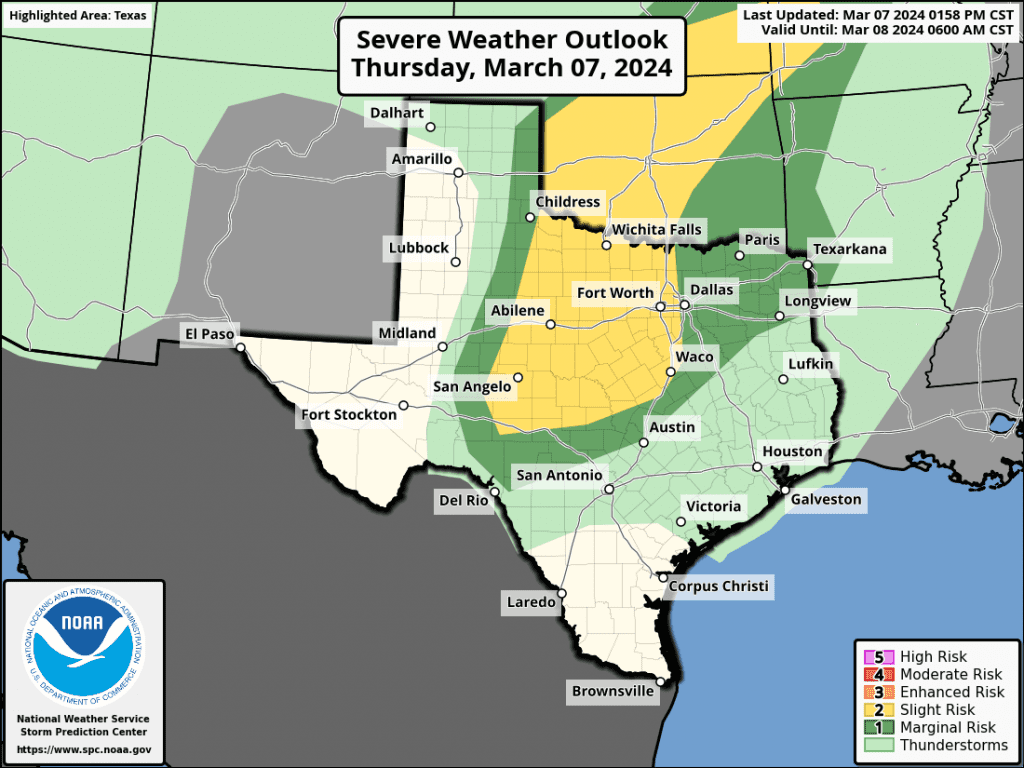
Some of these storms will have the potential to become strong to severe. The highest threat for severe storms is forecast to be mainly across the northern and central Hill Country, where the Strom Prediction Center and has placed this area under a Slight Risk (or 2 out of 5 risk) for severe storms through sunrise Friday. A Marginal Risk (or 1 out of 5 risk) for severe thunderstorms extends as far southeast as Bandera, Austin, and Rockdale. To the southeast of Austin, the threat for severe storms is expected to be quite low. The greatest severe weather threats will be large hail and damaging winds.
Rainfall from the scattered showers and thunderstorms today and tonight is forecast to stay under a quarter inch. Isolated totals to around a half inch will be possible.
The chance for rain will end from west to east Friday morning as drier air spreads in behind the cold front. The sky should become mostly sunny by the afternoon. A Canadian cold front is forecast to sweep southeast across the area Friday evening, bringing much cooler air and breezy conditions that will extend through Saturday. Sunny weather is predicted for both days. Expect northwesterly winds with speeds of 10-20 mph and gusts to 30 mph Friday night through Saturday afternoon.
- Lows Saturday morning are forecast to be near 38-40 degrees across the Hill Country, in the mid-40s across Central Texas, and near 50 degrees across the coastal plains.
- High temperatures Saturday and Sunday are predicted to be in the low and mid-60s.
- Lows Sunday and Monday mornings will range from the upper 30s across the Hill Country, to the mid-40s towards the coast.
Bob
Social Media