It’s shaping up to be a cloudy and wet weekend across the region as a couple of potent troughs of low pressure push east across Texas and the southern Plains. The rain is predicted to move out Sunday afternoon, followed by sunny and slight cooler weather early next week.
Friday’s satellite view showed widespread middle and high-level clouds spreading from the eastern Pacific, to Texas, and the Tennessee Valley. At the same time, moisture spreading north from the Gulf of Mexico was bringing considerable low-level clouds to much of the area. This trend is expected to continue Friday afternoon and Friday, resulting in an overcast to mostly cloudy sky. No significant rain is forecast Friday afternoon or evening, although a couple of brief, spotty showers will be possible for areas east of Interstate 35 . Expect a south breeze at 10-15 mph. Friday’s temperatures should climb to the low and mid-70s.
The chance for rain showers and scattered thunderstorms looks to increase across the Hill Country in the hours before daybreak Saturday as the first of two Pacific troughs of low pressure track into Texas out of northern Mexico. Forecasts call for the showers and thunderstorms to slowly spread east, covering the Central Texas and the middle Texas coastal regions Saturday morning through Saturday afternoon. The probability for rain Saturday will be near 80-90 percent. The rain is forecast to taper off across the Hill Country Saturday afternoon and in the late afternoon to early evening across Central Texas and the coastal plains.
There will be a small risk for a few Saturday’s storms to become strong to severe. The Storm Prediction Center has placed most of the region under a Marginal Risk, or 1 out of 5 risk, for severe thunderstorms. The primary severe weather threat is expected to be large hail, followed by marginally severe wind gusts and an isolated tornado.
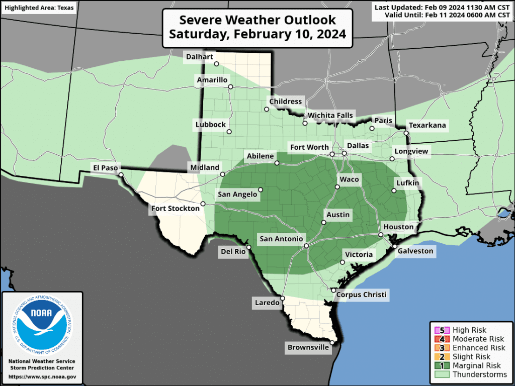
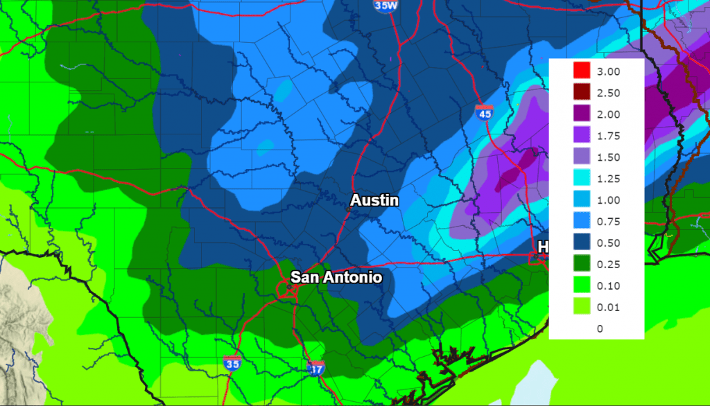
Unlike recent rain events, conditions this weekend appear more favorable to bring widespread rain to the Hill Country, along with the rest of the region. Rain amounts through Saturday evening are predicted to generally be in the range of 0.5 to 1 inch. Slightly higher totals to around 1.5 inches are forecast for the area between Bastrop and Columbus.
NWS Rainfall Forecast Valid for the Period through 6 am Sunday:
Occasional light rain showers are forecast across the region Saturday evening.
Attention then turns to Pacific trough number two that is forecast to sink south into Northwest Texas Saturday night, then move east across the southern Plains Sunday into Sunday night. The trough is expected to drive a Canadian cold front southeast across the region late Saturday night through midday Sunday. Forecasts call for an area of rain showers and scattered thunderstorms to develop across the Hill Country beginning around midnight Saturday night as the cold front pushes east out of West Texas. Showers and scattered thunderstorms are predicted to spread east across Central Texas and the middle Texas coast late Saturday night through Sunday morning. The probability for rain will be near 80 percent. Once again, there will be a low-end threat for a couple of strong to severe thunderstorms that could produce large hail and damaging winds.
Rain amounts from this second round of rain showers and thunderstorms is forecast to generally average between a quarter and a half inch, with isolated higher totals.
The chance for rain looks to taper off from west to east late Sunday morning as the cold front pushes into the Gulf of Mexico. A mostly sunny sky is forecast across the region Sunday afternoon. Breezy and slightly cooler weather is predicted for Sunday afternoon and Sunday night. Expect a westerly wind at 10-15 mph, with occasional gust to 25 mph.
Sunday’s high temperature will range from the low 60s west, to the low 70s near the coast. Lows Sunday morning will include the mid-30s across the Hill Country, the upper 30s across Central Texas, and the low 40s towards the coast.
Sunny and dry weather is forecast next Monday through Wednesday. The sky will become mostly cloudy next Thursday. Daytime temperatures are forecast to be mild, with cool readings at night.
- A light freeze will be possible across the Hill Country and some low-lying areas of Central Texas Monday night. Lows Tuesday morning will include the low 30s across the Hill Country, the low and mid-30s across Central Texas, and the upper 30s across the coastal plains.
High temperatures Tuesday will be in the low 60s, warming to the upper 60s Wednesday and Thursday. Lows Wednesday and Thursday mornings are forecast to be in the 40s.
Forecasts point toward an increasing chance for rain across our region beginning next Friday, continuing through next Sunday as a slow-moving trough of low pressure moves north out of Mexico. No significant change in the temperature is forecast through the week of February 19th.
Have a good weekend!
Bob
Social Media