Key Messages
- Scattered showers and thunderstorms are forecast to develop and spread across the area beginning this afternoon, continuing overnight and into early Saturday
- Scattered strong to severe storms will be possible Friday evening and Friday night.
- The Hill Country and most of Central Texas, including the Austin metro, has been placed under a Slight Risk, or a 2 out of 5 risk, for severe storms through sunrise Saturday
- The primary severe threat will be large hail. There will be a secondary risk of damaging wind gusts and isolated tornadoes
- The primary window for severe storms across the Hill Country and Central Texas regions will be between 7 pm and 4 am
- Locally heavy rainfall will be possible from some of the storms
- Rain amounts through Saturday morning are forecast to generally be in the range of 0.5 to 1.5 inches
- Strong and gusty winds will develop Saturday and continue through late Sunday. A Wind Advisory will likely be posted soon for Sunday
Discussion
A portion of the powerful storm system which tracked inland across California Thursday is moving east and is expected to bring an increasing chance for rain showers and thunderstorms to our region beginning this afternoon. Ahead of this system, Gulf moisture is rapidly returning to Central and South Texas. With increasing atmospheric lift arriving from the west, scattered rain showers and isolated thunderstorms are predicted to develop across the Hill Country and Central Texas regions Friday afternoon. With atmospheric lift increasing and a favorable position of the jet stream, showers and thunderstorms are predicted to increase in areal coverage and intensity beginning Friday evening. Meanwhile, atmospheric conditions are predicted to become increasingly favorable for the development of strong to severe thunderstorms Friday evening—especially across the Hill Country and parts of Central Texas. The Storm Prediction Center has placed the Hill Country and the Austin/Interstate 35 corridor under a Slight Risk, or a 2 out of 5 risk, for severe thunderstorms through 6 am Saturday. The eastern half of Central Texas and the middle Texas coast has been placed under a Marginal Risk, or 1 out of 5 risk, for severe storms.
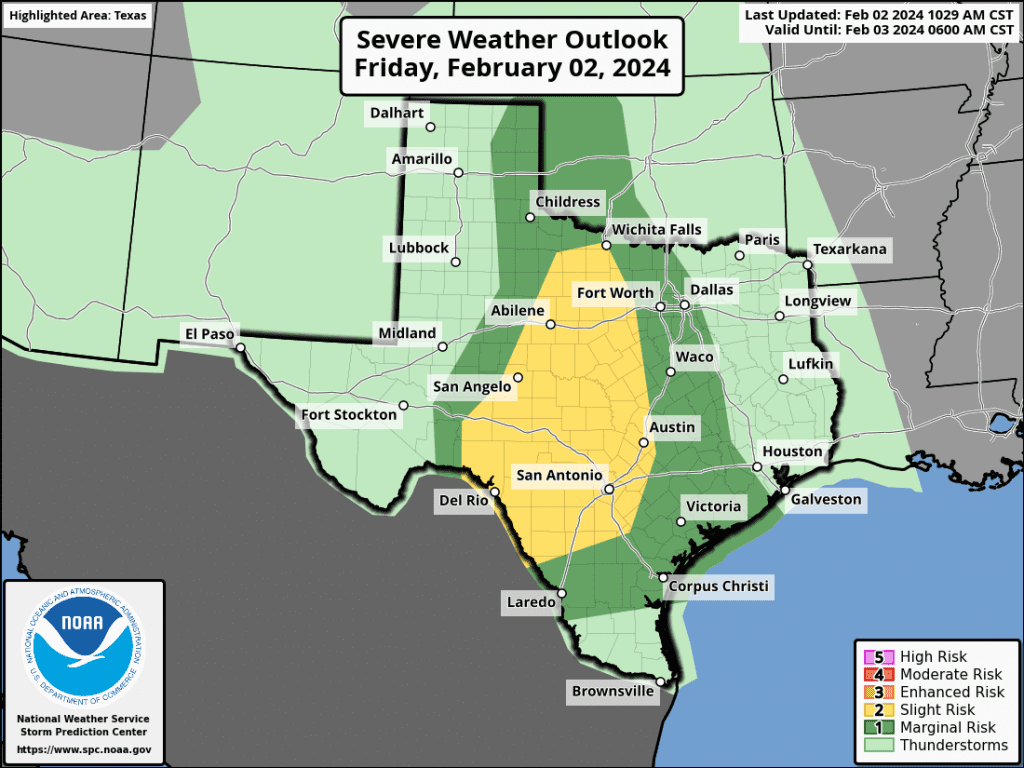
The main time period for severe storms is expected to be roughly between 7 pm Friday evening and 4 am Saturday.
The primary severe weather threat will be large hail. However, secondary threats of isolated damaging wind gusts to 60 mph and an isolated tornado or two will also be in play. The storms are forecast to exit the Hill Country and Central Texas regions by about sunrise Saturday, and the coastal region by mid-morning Saturday as a Pacific cold front brings in drier and more stable.
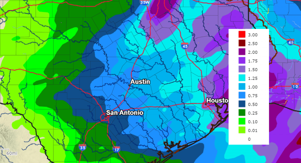
Moisture levels ahead of this system will support the development of some moderate to heavy rainfall, but due the progressive nature of the storms, rain totals are not forecast to be all that high. The National Weather Service is calling for widespread totals of 0.5 to 1.5 inches, with some isolated totals to near 2 inches towards the coast. The ground is still quite wet for areas along and east of I-35, and this additional rain will likely generate runoff into area creeks and rivers. But significant flooding concerns are not anticipated.
NWS Rainfall Forecast for the Period 6 pm Friday through 6 pm Sunday:
The rain and storms are forecast to push east into the Gulf of Mexico by mid-morning Saturday. Behind the Pacific cold front, the clouds will clear from west to east Saturday morning. Sunny and dry weather is forecast Saturday afternoon through Sunday.
- Saturday’s temperature is forecast to warm to around 68-70 degrees.
- Lows Sunday morning will be in the upper 40s.
- High temperatures Sunday are forecast to be in the mid-60s.
- Lows Monday morning will range from the low 40s west, to the upper 40s near the coast.
Winds
Breezy conditions will develop behind the Pacific cold front Saturday. Expect westerly winds with speeds of 10-15 mph, with gusts to 25 mph.
Stronger winds are predicted to develop Saturday night through Sunday as a second cold front moves across the area. For Saturday night through Sunday evening, expect westerly winds with speeds of 15-25 mph and occasional gusts to 40 mph. Wind speeds are forecast to decrease to 10-15 mph Monday.
Next Week
Sunny, dry, and mild weather is forecast next Monday through Thursday. Expect daily high temperatures in the 60s to low 70s, with lows in the 40s to low 50s. A chance for rain is forecast to develop next Friday into Saturday.
Have a good weekend.
Bob
Social Media