The wet and unsettled weather pattern continues but forecasters are beginning to see some dry weather on the near-term horizon. The latest wave of low pressure to move across Texas brought another round of rain showers and scattered thunderstorms to the area Tuesday night and Wednesday morning. As has been the case since Sunday, the highest totals from this latest wave of low pressure occurred over the area located east of Interstate 35. Rain amounts between midnight Tuesday and 2 pm Wednesday have generally averaged less than a tenth of an inch across the Hill Country, around a half inch along the I-35 corridor, and between 1 and 3 inches over the area between Bastrop and Matagorda Bay. It’s worth noting a series of storms producing heavy rain trained over Gonzales, Fayette, and Washington Counties Tuesday evening, producing widespread totals of 5-6 inches. Three-day rainfall totals over Fayette County are now between 10 and 12 inches!
Early this afternoon, the latest wave of low pressure is slowly tracking over the eastern half of Texas, producing widespread light to moderate rain. The rain is forecast to slowly taper off across Central Texas and the middle Texas by late afternoon. A cloudy sky will remain in place this afternoon. Temperatures will hold in the 50s across the Hill Country and Central Texas regions, and in the mid-60s across the coastal plains.
Wednesday’s data indicates there is still one more wave of low pressure currently located over northeastern Mexico that is set to move across Texas Wednesday night into Thursday morning. This system is forecast to cause the development of a large area of showers and thunderstorms near the Rio Grande this evening. The rain and storms are predicted to spread east-northeast across the Hill Country late this evening, across Central Texas near or shortly after midnight, and the coastal plains region after 4 am Thursday.
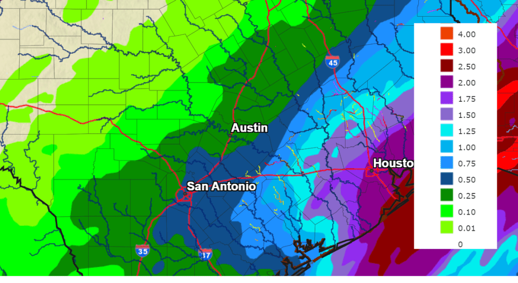
This next round of showers and thunderstorms looks to bring totals of close to a half inch to much of the Hill Country, between 0.5 and 1 inches to Central Texas, and between 0.5 and 2 inches for the coastal plains.
NWS Rainfall Forecast for the Period 6 pm Wednesday through 6 pm Thursday:
The National Weather Service has posted a flood watch for areas east of I-35 through noon Thursday. This watch includes Bastrop, Fayette, Colorado, Wharton, and Matagorda Counties.
The rain should end before daybreak across the Hill Country and Central Texas regions, and shortly after daybreak near the coast. Expect a cloudy sky through the morning, followed by some scattered sunshine in the afternoon. Thursday’s temperature is forecast to warm to the mid-60s.
The outlook for Friday calls for a 30-40 percent chance for rain showers across the northern Hill Country Friday afternoon into early evening as a small wave of low pressure pushes east out of the Panhandle. Rain amounts are forecast to average less than a quarter inch. Elsewhere, no rain is forecast. Expect a mostly sunny to partly cloudy sky with temperatures reaching the upper 60s.
Sunny, dry, and slightly cooler weather is predicted for the weekend. Expect high temperatures in the low 60s, with lows around 38-40 degrees.
The outlook for next week call for sunny weather with mild temperatures. Daily high temperatures will be in the 60s, with lows in the 40s.
The next chance for rain is predicted sometime next weekend, the first weekend of February.
Bob
Social Media