Cloudy, foggy, and damp weather continues on this Tuesday. The second of three waves of low pressure is currently moving east-northeast across the state. The rain from this wave so far has not been all that heavy, with most totals since measuring less than a half inch. High resolution forecasts call for additional scattered light to moderate rain showers and isolated thunderstorms to continue across the area through late afternoon as the wave of low pressure moves across the state. Some moderate to occasionally heavy rain will be possible across the coastal plains. Additional rain amounts through late afternoon are forecast to average less than a quarter inch across the Hill Country and Central Texas regions. Across the coastal plains, totals are forecast to average between a quarter and a half inch. Afternoon temperatures are forecast to hold in the 50s across the Hill Country, in the 60s across Central Texas, and in the low 70s across the coastal plains.
The chance for rain looks to decrease temporarily this evening as this second wave of low pressure exits to the northeast. Areas of fog will likely continue Tuesday night into Wednesday morning. The fog may become quite dense at some locations.
Forecasts call for the third and final wave of low pressure to track northeast out of Mexico late Tuesday night into Wednesday morning. This wave is forecast to lift northeast across the eastern half of the state, with the most favorable area for rain predicted to generally be along and east of the path of the wave of low pressure—meaning generally along and to the east of Interstate 35. Rain showers and scattered thunderstorms are predicted to develop across Southwest Texas Tuesday evening, then spread northeast to the eastern Hill Country, Central Texas, and the middle Texas coast after midnight Tuesday night, continuing into Wednesday morning. The rain is forecast to taper off across the Hill Country and Central Texas regions Wednesday afternoon and across the coastal plains region Wednesday evening.
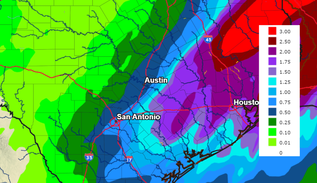
With a very moist atmosphere in place, significant totals of rain are expected for areas east of Interstate 35 with this next wave of low pressure. Here, forecasts through Wednesday evening call for totals of between 1-3 inches. Some isolated higher totals will be possible for areas south of Interstate 10. Since the ground is quite wet from recent rains, the National Weather Service is closely monitoring the situation and may post a Flood Watch for the coastal plains region Wednesday. In addition, some of Wednesday’s storms will have the potential to be strong to severe for areas south of Interstate 10. The Storm Prediction Center has placed this region under a Marginal Risk (a 1 out of 5 risk) for severe thunderstorms through Wednesday evening.
Totals across the Austin/Interstate 35 corridor are forecast to average between 0.5 and 1.5 inches. Further west across the Hill Country, totals are forecast to average between a quarter and a half inch.
NWS Rainfall Forecast for the Period 6 pm Tuesday through 6 pm Wednesday:
The chance for rain is forecast to diminish from west to east Wednesday evening as drier and slightly cooler air spreads into the area behind a weak cold front. Lows Thursday morning will range from the 40s across the Hill Country, to the low and mid-50s across the coastal plains. Mostly sunny and dry weather will be in place Thursday. Expect high temperatures generally in the upper 60s.
Friday’s weather will include a 40 percent chance for afternoon rain showers as a second cold front pushes east across the area. The rain is predicted to be light, with most totals averaging less than a quarter inch. Dry weather will follow Friday night and through the weekend. High temperatures are forecast to be in the upper 60s on Friday, cooling to the low 60s Saturday and Sunday. Low temperatures will generally be in the upper 30s to low 40s.
Bob
Social Media