Here’s an update on weekend weather conditions and a look at the wet weather pattern that will be taking shape next week.
Key Messages
- Colder temperatures have returned to the area and will continue through the weekend
- Expect a hard freeze Friday night. Lows Saturday morning will range from around 20 degrees across the Hill Country, to the upper 20s towards the coast
- No precipitation is forecast through Sunday morning
- A wet weather pattern looks to begin Sunday afternoon/Sunday evening and will continue through late next week
- The first wave of rain occurring late Sunday through Monday afternoon is forecast to produce totals of 1-2 inches for areas along and east of Interstate 35. Hill Country totals of 0.5 to 1 inch are forecast
- Cumulative totals through Thursday are predicted to range from 1-2 inches across the Hill Country, to more than 5 inches for areas south of Interstate 10
Discussion
An arctic cold front pushed through the region Thursday night, bringing a return of more breezy and colder weather. Fortunately, the air behind this front won’t be quite as cold as what moved into our area early in the week. However, the air mass will still be cold enough to bring a widespread, hard freeze to most of the area Friday night. Strong northerly winds have developed behind the cold front and are forecast to continue through late Friday afternoon. Expect wind speeds of 15-25 mph, with occasional gusts up to 40 mph. Wind speeds should decrease to around 10-15 mph Friday evening and Friday night. The sky is forecast to be clear Friday through Friday night.
- Lows Saturday morning are predicted to be close to 20 degrees across the Hill Country, in the low 20s across the Austin/Central Texas area, and in the mid to upper 20s across the coastal plains.
Saturday’s weather is looking mostly sunny and quite cool. High temperatures will generally be in low 40s. Expect a northeasterly breeze at 5-10 mph. Saturday night into Sunday morning will again be cold with a light freeze for the Hill Country and Central Texas regions. However, readings will be a bit warmer than Saturday morning’s lows.
- Lows Sunday morning will include the mid and upper 20s across the Hill Country, the upper 20s to low 30s across Central Texas, and the mid to upper 30s coastal plains.
The Start of a Wet Weather Pattern
The cold pattern we’ve been in for the past week looks to transition to a milder and more unsettled pattern beginning Sunday as the jet stream shifts from originating in the arctic to a flow out of the Pacific. This is shaping up to be a wet pattern for much of Texas, and especially for areas east of Interstate 35.
Southeasterly winds will return to the area beginning Sunday morning as the arctic high pressure shifts to the northeast. A cloudy sky is expected to develop early Sunday morning and continue throughout the day as Gulf moisture overruns the chilly air at the surface. The atmosphere is forecast to become quite moist by Sunday afternoon. As a result, there will be a 30-40 percent chance for scattered, mostly light rain showers throughout the afternoon. With widespread clouds in place, Sunday’s temperature is predicted to only warm to the low and mid-40s, with some low 50s expected towards the coast.
Forecasts call a Pacific trough of low pressure to push inland and reach the Four Corners region Sunday afternoon. The trough is predicted to track to the east-northeast Sunday night into Monday, drawing considerable moisture north from the Gulf and eastern Pacific. Atmospheric conditions appear favorable for the development of widespread rain showers and scattered thunderstorms beginning Sunday evening, continuing into Monday afternoon. The rain is predicted to become heavier after midnight Sunday night. In fact, the rain is predicted to become moderate to occasionally heavy across Central Texas and the middle Texas coast. The rain looks to decrease Monday afternoon into Monday night as the trough of low pressure exits our region.
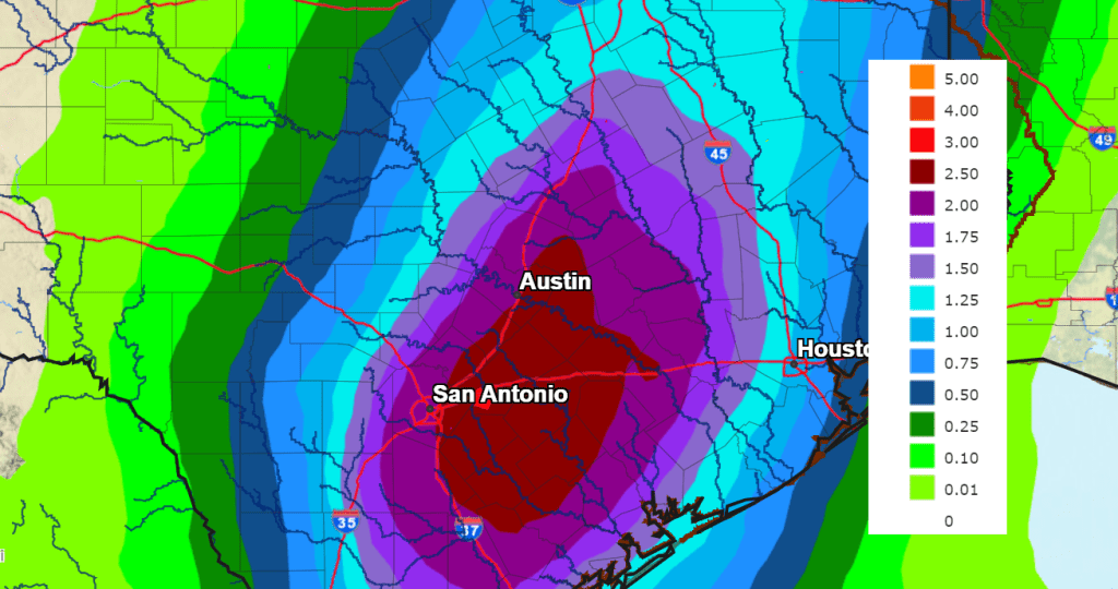
Rainfall forecasts for the period from Sunday afternoon through Monday evening call for general totals of 0.5 to 1 inch across the eastern Country, and between 1 and 2 inches for Central Texas and the middle Texas coast. Lower totals are predicted for the western and central Hill Country.
The National Weather Service’s rainfall forecast valid through 6 pm Monday.
Forecasts call for a second trough of low pressure to move into Arizona and New Mexico Tuesday. This system is forecast to cause the development of more widespread showers and thunderstorms across our region Tuesday afternoon through Tuesday night. This next system is forecast to produce totals of close to a half inch across the Hill Country, and between 1 and 2 inches across the rest of the region. Some higher totals will be likely towards the coast
Additional periods of rain showers and scattered thunderstorms are forecast Wednesday through Thursday as more waves of low pressure move in from the Pacific. The chance for rain is expected to decrease next Friday. However, some solutions indicate the wet pattern could extend into next weekend.
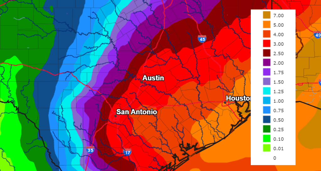
The National Weather Service’s rainfall seven day rainfall forecast through 6 am Thursday calls for general totals of 1-2 inches across the Hill Country, 2-4 inches across Central Texas, and 3-5 inches+ across the middle Texas coast:
As of now, severe storms are not anticipated with next week’s rain. Temperatures next week look to be fairly mild, with highs in the 60s and lows close to 50 degrees. No additional arctic air is on the horizon for at least the next two weeks.
Bob
Social Media