Here’s my Friday update on the upcoming arctic air that will be arriving late Saturday and is expected to persist into the middle of next week.
Important Forecast Changes
- The arctic front’s forecast arrival time has now sped up to Saturday night
- The temperature forecast has trended slightly colder
- Light freezing rain and sleet probabilities have increased for Sunday night into Monday morning
Friday’s Strong Winds
Strong northwesterly winds of 20-30 mph with occasional gusts to 40 mph are occurring across the region Friday morning due to a strong pressure gradient behind the departing low pressure system. The strong winds are predicted to continue into early afternoon, then decrease to around 10-20 mph mid to late afternoon. Wind speeds should decrease to 5-10 mph Friday evening and Friday night.
Discussion
High-resolution forecast data from Thursday night indicates the much anticipated artic cold front will be moving through the area even earlier than previously predicted. As of mid-morning Friday, the leading edge of the brutal arctic air had pushed south of the Canadian border and was located over southern Montana. Updated forecasts call for the front to plunge south tonight and Saturday, reaching the Red River Valley early to mid Saturday afternoon. The front is forecast to reach the northern Hill Country late Saturday evening, the Austin area shortly after midnight Saturday night, and the coast by sunrise Sunday. No precipitation is forecast along the front. Behind the front, northerly winds will increase to 10-15 mph, with occasional higher gusts. The temperature will trend much colder by early Sunday morning and readings will remain quite chilly throughout the day. Wind chill readings in the teens and 20s are forecast across the area Sunday morning. Note that for much of the Hill Country, the temperature is expected to fall below freezing early Sunday morning and it will likely not warm above freezing until Wednesday afternoon.
- Lows Sunday morning are forecast to be in the upper teens to 20 degrees across the Hill Country, the mid-20s to 30 degrees across Central Texas, and the mid-30s across the coastal plains.
- Temperatures Sunday are not forecast to warm significantly. Highs will range from the low 30s across the Hill Country, to the mid-30s across Central Texas, to the mid-40s across the coastal plains.
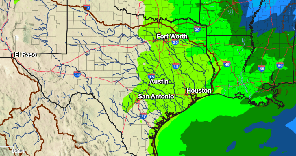
Sunday evening, forecasts are now converging on a solution where a small trough of low pressure will be tracking to the east out of West Texas. As this occurs, light overrunning wintery precipitation is predicted to develop over parts of the Hill Country, Central Texas, and even the middle Texas coast. The area will generally be to the east of a line stretching from San Saba to Fredericksburg, and north of a line stretching from Victoria to San Antonio. The chance for wintery precipitation is expected to begin Sunday evening and continue into Monday morning. The National Weather Service has put the probability for precipitation at 30 percent. The chance for precipitation looks to end mid to late Monday morning as the trough exits to the east. Due to the shallow depth of the cold air, the precipitation will mainly be in the form of light freezing rain with a few sleet pellets. Minor ice accumulations, mainly on elevated bridges and surfaces, will be the main threat should freezing rain occur. Dry weather conditions are forecast Monday afternoon through Wednesday.
The Weather Prediction Center’s Forecast for Light Precipitation through 6 am Tuesday:
Very cold weather is forecast Monday through Wednesday morning. Hard freezes can be expected across the entire region. The arctic air is forecast to move out of our area Wednesday afternoon and Wednesday night.
Here’s a rundown of the latest temperature forecast for the period:
- Lows Monday morning are forecast to be between 15 and 20 degrees across the Hill Country, between 20 and 25 degrees across Central Texas, and the upper 20s across the coastal plains.
- High temperatures Monday are predicted to be upper 20s across the Hill Country, near in the low to mid-30s across Central Texas and the middle Texas coast.
- Low temperatures Tuesday morning are forecast to near 8-12 degrees across the Hill Country, between 10 and 17 degrees across Central Texas, and close to 20 degrees across the coastal plains.
- High temperatures Tuesday are forecast to be in the upper 20s across the Hill Country, the low 30s across Central Texas and the middle Texas coast.
- Lows Wednesday morning are predicted to be near 15-18 degrees across the Hill Country, near 15-18 degrees across Central Texas, and around 20 degrees across the coastal plains.
- High temperatures Wednesday are forecast to be in the upper 40s.
Cold weather preparations should be underway and need to be completed by Saturday evening. Proper precautions will help to mitigate damages to infrastructure, pets and livestock, plants, and people.

Bob
Social Media