Here’s an update on the outbreak of arctic air that is predicted to arrive Sunday afternoon and remain across the area through the middle of next week. Preparations should begin now for two or three nights hard freezes.
A deep trough of low pressure developing over southern Canada and the Great Lakes region late this week is predicted to dislodge an area of bitterly cold arctic from northern Canada, allowing some of this air to flow south through Texas on Sunday. Forecasts call for the leading edge of the arctic air to push south of the Red River just after sunrise Sunday morning, then plunge south through Central Texas Sunday afternoon, moving off the middle Texas coast Sunday evening. The front is forecast to be dry, with no precipitation developing along or behind it as it moves to the south.
In general, weather conditions are forecast to be dry during this cold weather event, with no wintery precipitation. However, I will point out that one of the more reliable forecast solutions does indicate there will be a very slight chance for some light snow flurries to develop over areas along and east of Interstate 35 across Central Texas Sunday night through about midday Monday. The probability for precipitation will be less than 20 percent and if precipitation does develop, no accumulations are forecast. It should be noted most of the other forecast solutions keep weather conditions dry Sunday night through next Wednesday.
The biggest news with this arctic outbreak will be the drastic change in the temperature. Ahead of the cold front, temperatures Sunday afternoon are predicted to warm into 50s to low 60s. But behind the front, temperatures will rapidly fall through the 40s and 30s, with a widespread hard freeze developing Sunday night. Forecasts call for the arctic air to continue spreading south across the state Sunday night through Tuesday, with milder air finally returning on Wednesday.
- Low temperatures Monday morning are forecast to be between 15 and 20 degrees across the Hill Country, Texas, with the low and mid-20s expected across Central Texas and the middle Texas coast.
- Monday’s weather is predicted to be partly cloudy, breezy and quite cold. High temperatures include the upper 20s to 30 degrees across the Hill Country, and the mid 30s across Central Texas and the coastal region.
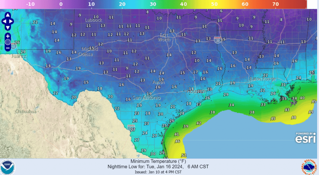
- Monday night is shaping up to be the coldest night of the period as the strong winds diminish. Lows Tuesday morning are forecast to be between 10 and 15 degrees across the Hill Country, be around 15-17 degrees across Central Texas, and be close to 20 degrees across the coastal plains.
- Tuesday’s weather is shaping up to be mostly sunny and continued cold. High temperatures will generally be in the upper 30s across the area.
- Tuesday night will be another very cold night, but not nearly as cold as Monday night. Lows Wednesday morning are forecast to be in the low 20s across the Hill Country and Central Texas regions, and in the mid to upper 20s across the coastal plains.
- Wednesday is looking to be mostly sunny and milder, with high temperatures in the low and mid-50s.
- Lows Thursday morning will be in the 30s to low 40s.
Predicted Low Temperatures for Tuesday Morning:
Seasonal temperatures are forecast late week and into the following weekend. No additional arctic air is on the horizon through at least January 25th.
All interests should begin making preparations for this upcoming period of very cold weather and hard freezes. Remember to protect your pipes, plants, and pets. Make sure everyone in your family has a warm place to stay.
Bob
Social Media