…A Significant Wind Event is Expected to Develop Late Monday into Tuesday…
A trough of low pressure moving northeast out of West Texas brought another round of rain to our region Thursday night. Hill Country totals generally averaged between a third and a half inch. Across Central Texas, totals ranged from around a tenth of an inch in the Austin area, to nearly an inch at La Grange. The rain was quite a bit heavier across the middle Texas coast in the vicinity of a coastal low. Here, totals generally ranged between 1 and 2.5 inches. All of the rain exited the area shortly after sunrise Friday.
Sunny and dry conditions have developed in the wake of Thursday night’s rain and similar conditions are forecast to continue Saturday through Sunday. Daytime temperatures will be mild, but it will be chilly at night. A light freeze is forecast across the Hill Country Saturday morning. Early Sunday morning, a light freeze will be possible across the Hill Country along with parts of Central Texas.
- High temperatures Friday are forecast to be in the low and mid-60s.
- Lows Saturday morning will include the low and mid-30s across the Hill Country, the mid and upper 30s across Central Texas, and be close to 40 degrees across the coastal plains.
- High temperatures Saturday and Sunday are predicted to be in the low and mid-60s.
- Low temperatures Monday morning are forecast to be in the upper 40s to low 50s.
- High temperatures Monday are forecast to be in the low and mid-70s.
There will be a change in the weather beginning after midnight Sunday night when the third in a series of low pressure troughs begins to track from the Four Corners region to the southern Plains states. This system is expected to draw considerable moisture north from the Gulf of Mexico beginning late Sunday evening. With increasing moisture levels, scattered rain showers and even a couple of isolated thunderstorms are forecast to develop across the region late Sunday night into Monday morning.
A better chance for rain showers and scattered thunderstorms is predicted to develop along a Pacific cold front Monday morning into Monday afternoon. The front is forecast to move across the Hill Country Monday morning, the Austin/Interstate 35 corridor midday into early afternoon, and the area between La Grange and Columbus in the mid to late afternoon. The front is predicted to push off the middle Texas coast Monday evening. The probability for rain will be near 50 percent. The rain is forecast to end from west to east Monday afternoon behind the cold front.
There will be a threat for some of the thunderstorms to be strong to severe along the cold front from around the Giddings/La Grange area, southeast to the coast. In this zone of greatest instability, isolated tornadoes, large hail and damaging winds will be possible.
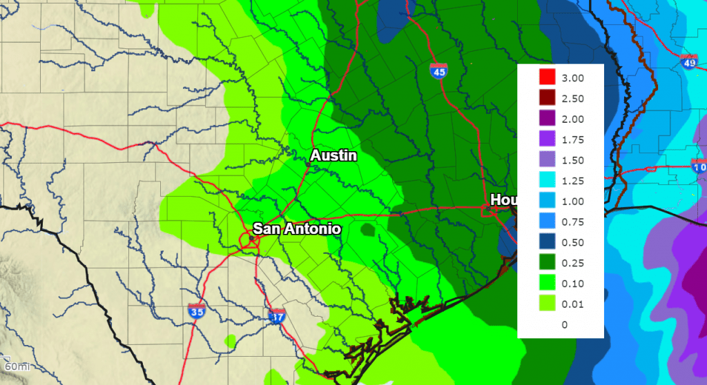
Total rainfall is not expected to be very heavy. Forecasts call for totals to average less than a quarter inch for areas west of Interstate 35. For the area east of Interstate 35, expect totals to average between a quarter and a half inch.
NWS Rainfall Forecast Valid through 6 pm Wednesday, Jan. 10th
In the wake of Monday’s cold front, a strong pressure gradient is forecast to develop across the state which is expected to cause the development of very strong west and northwesterly winds. Forecasts call for wind speeds to increase to 20-30 mph, with gusts between 40 and 50 mph beginning late Monday afternoon, continuing Monday night and through about mid-afternoon Tuesday. The winds are forecast to decrease Tuesday evening. The National Weather Service states they cannot rule out some isolated gusts up to 60 mph. Preparations should be made today and this weekend in advance of the very strong winds!
Sunny and dry weather is forecast next Tuesday through Friday. High temperatures are forecast to be in the low 60s, with lows in the upper 30s to low 40s.
Long-range forecasts are indicating temperatures will trend a bit colder for the week of January 15th. However, the focus of this cold air outbreak is predicted to be more toward the eastern U.S. rather than into Texas.
Have a great weekend!
Bob
Social Media