A clear sky, light winds, and a chilly air mass all combined Sunday night to produced the first widespread freeze of the season. Low temperatures Monday morning generally ranged from the mid-20s to low 30s across the Hill Country and Central Texas. A few spots south of Interstate 10 also saw readings at or below freezing. According to LCRA’s Hydromet, the lowest temperature observed Monday morning was 21 degrees at a couple of sites located between Brownwood and Abilene. In Austin, Camp-Mabry recorded a low temperature of 31 degrees—marking the first official freeze of the season. At Austin-Bergstrom, the low temperature was 24 degrees, which tied the record low of 24 degrees first set in 1978.
The week is starting off sunny in the wake of Saturday’s strong cold front. Canadian high pressure which followed the front has already shifted east to the lower and middle Mississippi Valley, causing surface winds across Texas to turn southerly. Light southerly breezes are forecast to continue Monday afternoon through Monday night, bringing a return of slightly warmer air.
- Monday’s temperatures is forecast to generally reach the mid-60s.
- It won’t be nearly as cold Monday night. Lows Tuesday morning are forecast to be in the upper 30s across the Hill Country and Central Texas, and in the low 40s across the coastal plains.
Some changes in the weather are forecast to take place Tuesday in advance of a large trough of low pressure pushing inland along the Pacific Northwest. The trough is expected to pull a large area of middle and high-level clouds across Texas out of the eastern Pacific Tuesday afternoon through Tuesday night. This will result in a partly to mostly cloudy sky.
- High temperatures Tuesday are forecast to be in the mid and upper 60s.
- Lows Wednesday morning will range from the upper 40s to low 50s
The weather pattern is predicted to steadily become more unstable the second half of the week as the large trough over the Pacific Northwest sinks southeast to the Desert Southwest on Tuesday. From there, the trough is forecast to slowly push east across Texas Thursday and Friday, finally exiting to the east of Texas on Saturday. Ahead of the trough, a southerly wind flow is forecast to strengthen across the western half of the state Wednesday, causing moisture levels to increase. Moisture is forecast to increase across Central Texas and the coastal plains region Thursday into Friday.
The increased moisture is expected to cause the development of scattered rain showers across the Hill Country region Wednesday, and across the entire region Thursday. The probability for rain will be near 30 percent Wednesday and around 40-50 percent on Thursday. Rain amounts through Thursday are forecast to generally stay below a quarter inch.
- High temperatures Wednesday and Thursday are forecast to be in the low 60s.
- Lows Thursday and Friday mornings are forecast to be in the upper 40s.
Forecasts call for an increasing chance for rain showers and a couple of isolated thunderstorms beginning Thursday night, continuing through Friday night as the upper trough slowly moves east across the state. Abundant low-level moisture and increasing atmospheric lift will combine and are expected to produce widespread rain through Friday night. The rain is forecast to slowly taper off from west to east on Saturday. Due to the slow movement of this system, some significant totals of rain will be possible.
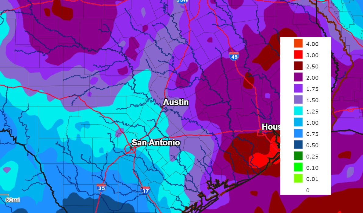
National Weather Service rainfall forecasts covering the period through next Monday call for widespread rain amounts of between 1 and 2 inches, with isolated totals of 3-4 inches.
NWS Rainfall Forecast for the Period 6 pm Monday through 6 pm next Monday:
- High temperatures Friday and Saturday are forecast to be in the low and mid-50s.
- Lows Saturday and Sunday mornings are forecast to be in the low and mid-40s.
A mostly sunny and dry pattern is predicted to develop Sunday as the upper trough moves off to the east. The weather looks to stay mostly sunny and dry all of next week as a stable ridge of high pressure sets up across the south central U.S. Temperatures are forecast to trend milder, with highs expected to be in the 60s, and lows mainly in the 40s.
There are still no signs of any arctic air spreading south to Texas over the next two week period.
Have a good week.
Bob
Social Media