Scattered sunshine and warmer weather will return to our region today. However, the warmer weather will be very temporary as cooler readings will return by Monday evening.
All eyes are on a Canadian cold front that will pushing across the area this afternoon. As of midday, the front stretched from the DFW area, southwest to Fredericksburg and Del Rio. The front is forecast to move across Central Texas this afternoon and the coastal plains Monday evening. Due to the lack of moisture in place, no rain is expected along the cold front when it moves across the Hill Country and Central Texas. There will be a slight chance for a few rain showers or isolated thunderstorms across the coastal plains region, but rain amounts should stay below a tenth of an inch. Noticeably cooler air will spread in behind the cold front Monday evening and Monday night. The cool air will then remain in place across our area throughout the week.
Ahead of the cold front, temperatures are forecast to warm into the low and mid-70s across the Hill Country, into the upper 70s to near 80 degrees across Central Texas, and into the low 80s across the coastal plains.
Behind the cold front, westerly winds with speeds of 10-15 mph can be expected Monday afternoon and evening. Northerly winds with speeds of 15-25 mph and gusts to 35 mph are forecast to develop Monday night and continue through Tuesday afternoon. Wind speeds should decrease to 10-15 mph Tuesday evening. The sky is forecast to be partly cloudy Monday night and be mostly sunny Tuesday through Wednesday.
- Lows Tuesday morning will include the mid and upper 40s across the Hill Country, the upper 40s to 50 degrees across Central Texas, and the low 50s across the coastal plains.
- High temperatures Tuesday are forecast to be in the upper 50s to low 60s.
- Lows Wednesday morning will range from the mid and upper 30s across the Hill Country, to the mid-40s across the coastal plains.
- High temperatures Wednesday are forecast to be around 58-60 degrees.
A slight chance for rain showers is now in the forecast for the period between late Wednesday night and about midday Thanksgiving Day thanks to a trough of low pressure that is forecast to sink south into Central Mexico. The trough is predicted to push east across Deep South Texas Thursday morning, then exit into the Gulf of Mexico Thursday afternoon. With limited moisture in place, just a few sprinkles of light rain are forecast. The approaching system will cause a cloudy sky Wednesday night and Thursday morning. The sky is forecast to clear Thursday afternoon and be mostly sunny Friday through Saturday.
- Lows Thursday morning will range from the upper 30s across the Hill Country, to the mid-40s across the coastal plains.
- High temperatures Thanksgiving Day are forecast to be in the upper 50s.
- Lows Friday morning will range from the upper 30s across the Hill Country, to the low 40s across the coastal plains.
- High temperatures Friday are forecast to be in the mid and upper 60s.
- Lows Saturday morning will range from the upper 30s west, to the mid-40s near the coast.
- High temperatures Saturday are predicted to be in the mid and upper 60s.
Forecasts call for a period of light rain to develop next Sunday into Monday when another trough of low pressure sinks south out of the Rockies and moves across North Texas. This system is expected to pull a bit more moisture north from the Gulf and this should result in a little higher rain amounts. Totals through next Tuesday are forecast to average between 0.25 and 0.5 inches across Central Texas and the coastal plains, and be less than a quarter inch across the Hill Country. A cold front will follow this system, bringing more cool air.
The outlook for next Tuesday through Friday calls for generally sunny and dry weather. High temperatures next week are predicted to be around 60-62 degrees, with lows in the 40s. Long-range forecasts are still not showing any arctic air headed to Texas over the next 2-3 weeks.
Tropical Weather Outlook
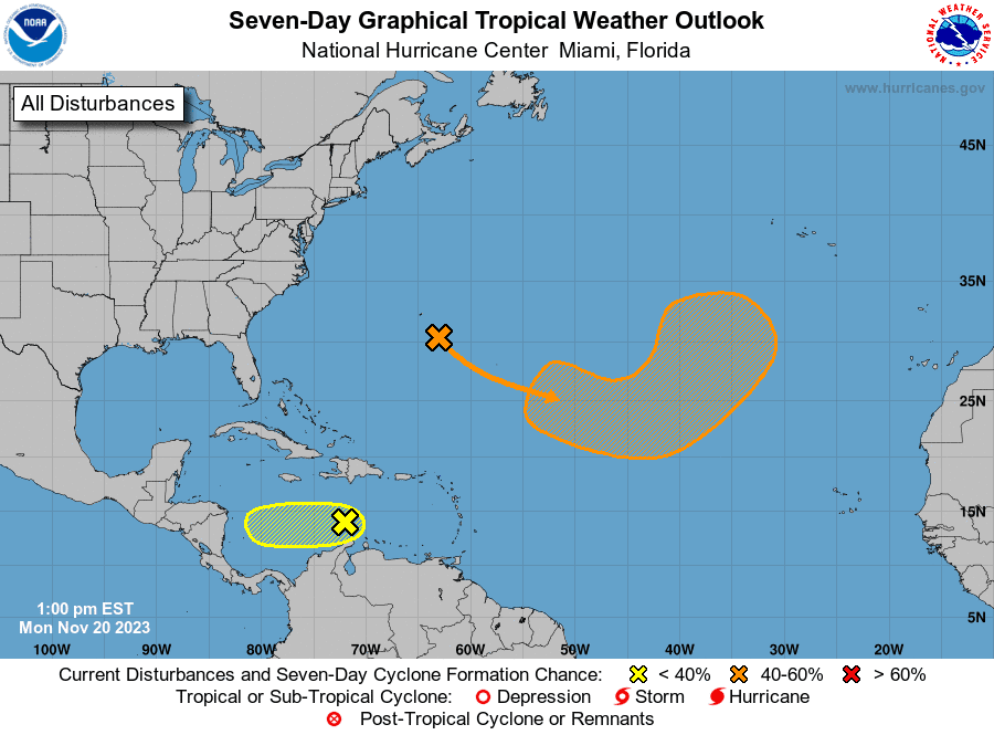
National Hurricane Center forecasters are monitoring two areas of disturbed weather, but neither system poses a threat to the Gulf of Mexico .
Out in the central Caribbean Sea, satellite wind data indicated a small but well-defined area of low pressure producing winds of 25-30 mph. However, the associated shower and thunderstorm activity with this system remains disorganized, and nearby dry air is forecast to prevent much additional development as the system begins to drift slowly westward over the next few days. NHC forecasters are giving this system only a 10 percent chance for development over the next seven days.
In the central tropical Atlantic, an area of low pressure appears to be developing along a frontal boundary just to the southeast of Bermuda. This non-tropical low is forecast to move southeastward across the central subtropical Atlantic over warmer sea surface temperatures during the next few days, and environmental conditions appear conducive for this system to gradually acquire tropical characteristics. A subtropical or tropical storm could form by the latter part of this week, as the system continues moving eastward. This motion will be followed by a turn to the northeast by the weekend. NHC forecasters are giving this system a 40 percent chance for tropical development over the next seven days.
Have a great, safe week and a Happy Thanksgiving!
Bob
Social Media