A Chance for Rain Monday. Temperatures Trending Cooler All Next Week
NOV. 17, 2023
Quiet weather conditions are in place as we close out the week, and these quiet conditions are expected to continue through the weekend. Areas of fog and low clouds this morning should will give way to mostly sunny conditions this afternoon. A weak, Pacific cold currently located late Friday morning across Northwest Texas is predicted to sweep southeast across the area in the afternoon, then move off the coast late evening. There will be no rain or big temperature drop along the front. Behind the front, the wind will shift to the northwest with speeds of around 10 mph. Expect a mostly sunny sky and just slightly cooler temperatures Saturday.
- Friday’s high temperature will be in the mid and upper 70s.
- Lows Saturday morning are forecast to generally be in the mid and upper 50s.
- High temperatures Saturday are forecast to be in the low 70s.
- Lows Sunday morning are forecast to be in the upper 50s.
Sunday’s weather looks to start off cloudy. This will be followed by a partly cloudy sky in the afternoon. Southerly winds will increase to speeds of 10-15 mph, with gusts to 25 mph. There will be a very slight chance for a few light rain showers across North Texas and the northern Hill Country Sunday afternoon. However, rain amounts, if any, will stay below a tenth of an inch. High temperatures Sunday are forecast to be in the low and mid-70s.
A chance for scattered rain showers and thunderstorms is predicted Monday into Monday night when a trough of low pressure pushing east out of the southern Rockies helps push a strong cold front through Texas. Just a slight chance for rain is forecast Monday afternoon. However , the chance for rain showers and scattered thunderstorms will increase to around 50 percent Monday evening through Monday night along and behind the cold front. The chance for rain should diminish from northwest to southeast after midnight Monday night. The cold front is predicted to reach the northern Hill Country early Monday afternoon, then push southeast across Central Texas late Monday afternoon into Monday evening. The front should push off the coast sometime late Monday evening.
Rain amounts Monday through sunrise Tuesday morning are forecast to average less than a tenth of inch across the Hill Country and Central Texas regions, and average less than a quarter inch across the coastal plains.
Breezy and cooler conditions will follow the cold front Monday night through Tuesday. Parts of the Hill Country could see a light freeze Wednesday and Thursday mornings. Expect northwesterly winds with speeds of 10-20 mph and gusts to 30 mph Monday night through Tuesday night. Wind speeds should decrease on Wednesday. The sky will become sunny Tuesday in the wake of the cold front.
Sunny, dry weather with mild days and chilly nights are forecast next Tuesday through Thanksgiving Day.
- High temperatures are forecast to be in the mid-60s Tuesday through Thursday.
- Lows Tuesday morning will range from the mid and upper 40s across the Hill Country, to the low 50s near the coast.
- Lows Wednesday and Thursday mornings will include the mid-30s across the Hill Country, the upper 30s to low 40s across Central Texas, and the low to mid-40s across the coastal plains.
- High temperatures Friday are forecast to be near 70 degrees
Forecasts for late next week show a slight chance for rain developing next Friday as another cold front moves across the area. Rain amounts are forecast to remain below a quarter inch. Dry and cooler weather looks to follow next weekend, with highs in the 50s and lows in the 40s.
Looking out further into the week of November 27th, forecasts are pointing toward an increasing chance for rain through the first half of the week as an overrunning pattern sets up across most of Texas. High temperatures are forecast to be in the low 60s, with lows in the 40s and 50s. No widespread freezing temperatures are forecast through the end of the month.
Tropical Weather Outlook
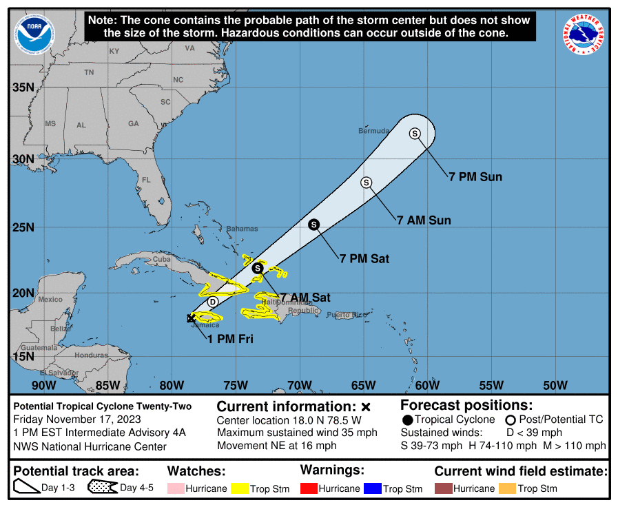
National Hurricane Cener forecasters are closely monitoring a strong tropical disturbance (Labeled Potential Tropical Cyclone Twenty-Two) located over the southwestern Caribbean Sea. The system is currently battling strong southwesterly wind shear and mid-level dry air. None of the global forecast models depict the development of a well-defined circulation. As a result, the prospects for the disturbance to become a tropical cyclone appear to be decreasing.
As of 1 pm CST Friday, the disturbance was centered about 50 miles southwest of Montego Bay, Jamaica. The system is moving faster toward the northeast near 16 mph, and an additional acceleration toward the northeast is expected through the weekend. On the forecast track, the system is expected to move across Jamaica this afternoon, southeastern Cuba by early Saturday, and the southeastern Bahamas and Turks and Caicos Islands on Saturday.
Maximum sustained winds are near 35 mph with higher gusts. Some slight strengthening is possible during the next couple of days, but the system’s chance of becoming a tropical cyclone appears to be decreasing.
The Leonids Meteor Shower Will Peak Saturday Morning
The famous Leonid meteor shower will be free of moonlight on the shower’s peak morning, November 18th.
When to watch: Watch late on the night of November 17 until dawn on November 18.
Duration of shower: November 3 through December 2.
Radiant: Rises around midnight, highest in the sky at dawn.
Nearest moon phase: First quarter moon falls on November 20. So there will very little interference from moonlight.
Expected meteors at peak, under ideal conditions: Under a dark sky with no moon, you might see 10 to 15 Leonid meteors per hour.
(courtesy Earthsky.org)
Have a great weekend!
Bob
Social Media