Widespread light to moderate rain developed across the region behind a cold front Thursday, with the rain persisting through Thursday night. As of late Friday morning, the rain had ended across Central Texas and moved into Southeast Texas. Another area of rain was occurring across the Coastal Bend and the offshore waters. Thursday’s rains produced widespread totals of 0.75 to 1.25 inches along the Austin and Interstate Corridor. Across the Hill Country, totals generally averaged around a half inch or less. To the southeast of Austin, totals of 0.5 to 1 inch were quite common. I will point out the highest totals since Thursday morning occurred across Wharton County and the Highway 59 corridor, where there were numerous totals of around 2 inches. An LCRA Hydromet gauge located in far western Wharton County recorded a 24-hour total of 2.21 inches.
A very efficient overrunning wet weather pattern developed Thursday into Thursday night in the wake of a potent cold front moving across the area. A trough of low pressure lifting northeast out of southern Arizona helped pull considerable moisture up and over the frontal boundary, resulting in the development of widespread light to moderate rain. With the trough now located over the southern Plains states, the majority of the overrunning rain has pushed east of our area. But the stalled cold front just off the middle and upper Texas coast looks to be the focus for additional rains through the weekend.
Friday afternoon through Friday night
The cloudy and cool weather will continue. There will be a slight chance for a few passing light rain showers across the Hill Country and Central Texas region as weak atmospheric disturbances lift northeast out of Central Mexico. Here, the probability for rain will be near 30 percent. Totals through daybreak Saturday are forecast to average less than a quarter inch. The most favorable area for rain through Friday night is expected to be over the coastal plains, generally along and south of Interstate 10. Here, the probability for rain will be near 80-90 percent. Totals through daybreak Saturday are forecast to average around an inch.
- High temperatures Friday are forecast to generally be in the upper 50s. Lows Saturday morning will range from near 50 degrees across the Hill Country, to the mid-50s towards the coast.
Veterans Day through Saturday Night
The cloudy and cool pattern looks to continue. There will be a 20-30 percent chance for occasional light rain showers across the Hill Country and Central Texas regions. Totals through daybreak Sunday will average less than a quarter inch. The most favorable area for rain looks to once again be across the coastal plains region, generally to the south of Interstate 10, in a zone of enhanced moisture. Rain amounts between daybreak Saturday and daybreak Sunday are forecast to total between 1 and 2 inches.
High temperatures Saturday are forecast to be near 60-62 degrees. Lows Sunday morning will range from the upper 40s across the Hill Country, to the mid-50s near the coast.
Sunday through Monday Night
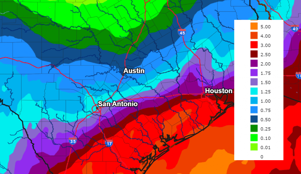
Another period of widespread rain is predicted to take shape Sunday, continuing through Monday night. Forecasts call for another large trough of low pressure to lift northeast out of Mexico and move across Northwest Texas, reenergizing the overrunning, wet weather pattern. Although there are some discrepancies in the forecast solutions, it appears the heaviest rains with this next system will fall over areas along and to the east of Interstate 35, with lower totals expected across the Hill Country.
There will a slight chance for showers across the area Sunday morning, followed by an increasing chance for rain showers Sunday afternoon through Sunday evening. Widespread rain showers and even a few scattered thunderstorms are forecast across the area Sunday night through Monday evening. A light to moderate rain intensity is forecast. with the probability for rain near 60-70 percent though the period. The rain is predicted to taper off from west to east late Monday night as the upper trough finally exits our region. The heaviest rains are forecast to occur across the coastal plains region between Sunday and Monday.
Rain amounts Sunday through Monday night are forecast to generally average between 0.5 and 1 inch across the Hill Country, and be between 0.5 and 1.25 inches across Central Texas. Across the coastal plains region, totals of 1-2 inches are forecast.
The National Weather Service’s cumulative rainfall forecast for the period 6 pm Friday through 6 pm Tuesday:
Dry weather is forecast beginning next Tuesday, continuing the following weekend. Lingering moisture may cause a partly to mostly cloudy sky each day, but some scattered sunshine can also be expected. Milder temperatures are forecast Highs in the 60s Monday through Wednesday will warm into the low and mid-70s Thursday through next weekend.
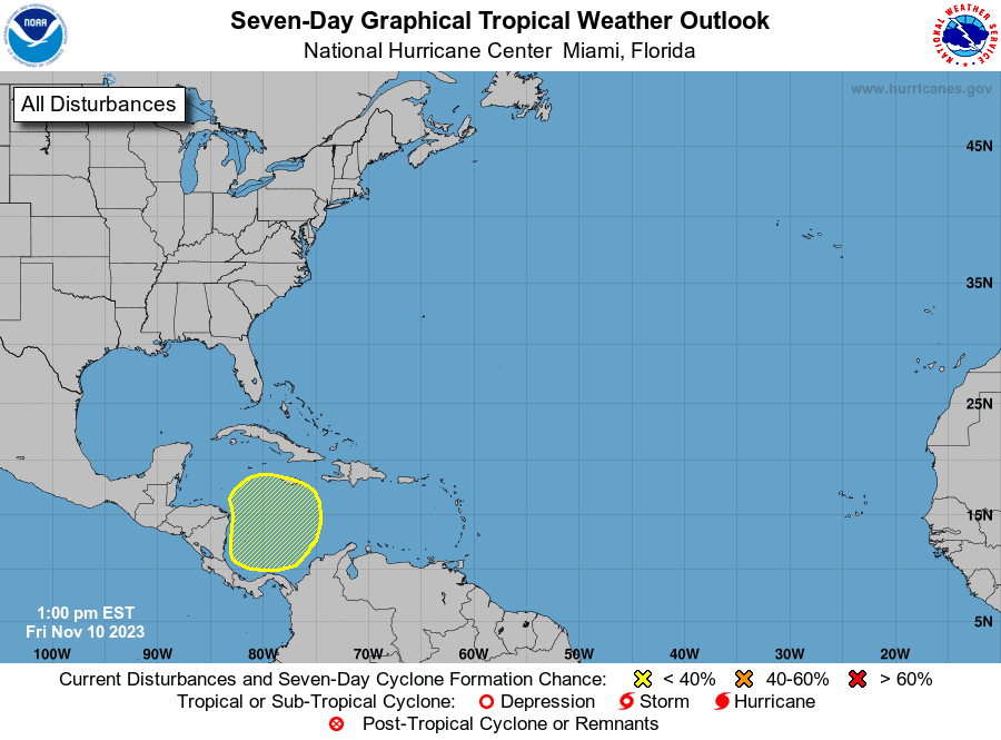
Tropical Weather Update
Weather conditions are generally quiet across the tropical Atlantic.
National Hurricane Center forecasters are monitoring a broad area of low pressure could that form in the southwestern Caribbean Sea by the middle of next week. Thereafter, environmental conditions appear conducive for gradual development of this system while it drifts slowly, remaining in the Caribbean Sea through the latter part of next week. NHC forecasters are giving this system a 30 percent chance for tropical development over the next seven days.
Have a great weekend!
Bob
Social Media