A Chance for Rain throughout the Week. Colder Weather on the Horizon?
OCT. 23, 2023
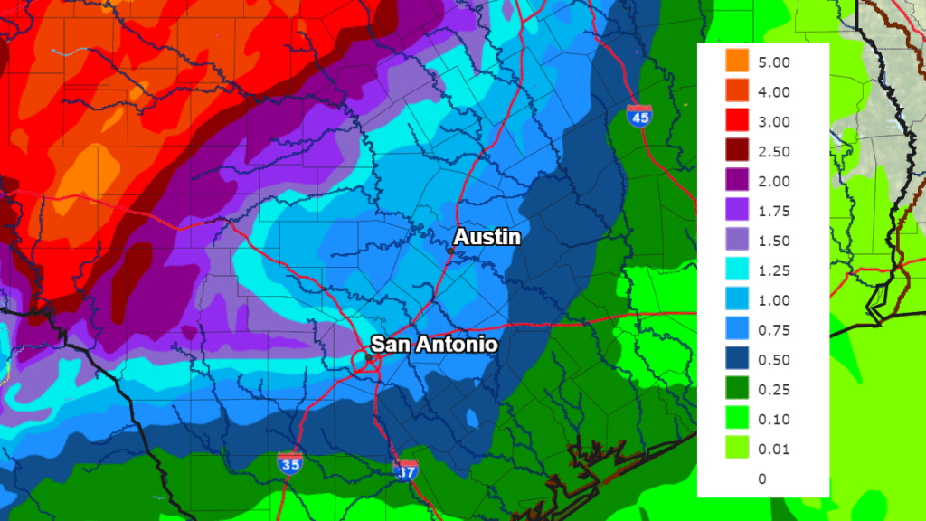
A wave of low pressure tracking north out of South Texas early Monday morning brought a widespread area of rain to much of the Interstate 35 corridor, from just north of San Antonio to north of Georgetown. The highest totals occurred across Travis County, where amounts of up to 1.5 inches were recorded. Elsewhere, most totals averaged less than a tenth of an inch.
The month of October has been drier than normal, with just one period of widespread rain occurring around the 5th. Since that time, the rain has stayed away from most of Texas, despite the passage of several cold fronts. As we start off the last full week of October, a wetter and more unsettled weather pattern has taken shape, thanks to a large trough of low pressure sinking south along the southern coast of California and the remnants of eastern Pacific tropical cyclone Norma that are spreading northeast across Far West Texas. In addition, a moist and warm flow of air has developed off the Gulf of Mexico. These factors are expected to cause a daily chance for rain this afternoon through Friday, with a slight chance for rain continuing into the upcoming weekend. While this rain will indeed be very welcome, this week’s setup is not expected to produce heavy rain across the eastern Hill Country or Central Texas.
This afternoon through Tuesday, the best coverage of rain is predicted to be across West and Northwest Texas along with the western Hill Country, where an enhanced area of Pacific moisture is forecast to slowly spread to the northeast, producing showers and scattered thunderstorms. The probability for rain across this area will be near 60 percent this afternoon through Tuesday night. Across Central Texas and the middle Texas coast, periods of scattered rain showers and isolated thunderstorms can be expected. The probability for rain will be near 50 percent this afternoon, decreasing to 30 percent Monday night and Tuesday. High temperatures both days are predicted to be in the mid-80s.
Rain amounts through Tuesday night are forecast to average between 0.5 and 1 inch across the western Hill Country, and less than a quarter inch at most other locations.
The most favorable period for rain and thunderstorms this week is forecast to take place Wednesday into Thursday morning, when the trough of low pressure out west tracks northeast, moving across Far West Texas and Panhandle regions. A widespread coverage of rain showers and thunderstorms is forecast to develop and spread northeast across West Texas, including the western Hill Country Wednesday into Wednesday night. A fairly good coverage of rain showers is also forecast across the eastern Hill Country, Central Texas, and coastal areas Wednesday. The probability for rain Wednesday through Wednesday night will be 70 percent across the Hill Country, and near 50 percent at most other locations. The rain is forecast to decrease in coverage and intensity Thursday morning.
Rain amounts Wednesday through Thursday morning are forecast to be near 1-1.5 inches across the western Hill Country. Totals across the eastern Hill Country and much of Central Texas are forecast to average between 0.5 and 0.75 inches. Across the coastal plains, totals are forecast to average around a quarter inch.
Decreasing chances for rain are forecast Thursday afternoon as the trough of low pressure exits to the northeast. However, lingering moisture, a moist flow off the Gulf of Mexico, and some weak waves of low pressure lifting north out of Mexico will cause a 20-30 percent chance for mainly afternoon and evening showers and isolated thunderstorms Friday through Sunday. Rain amounts through this period will be low—generally around a quarter inch or less. Expect a partly to mostly cloudy sky, with daily high temperatures in the low and mid-80s.
Total rain amounts over the next five days are forecast to range from 2-4 inches across the western Hill Country, to around 0.5 to 1 inches along the Interstate 35 corridor, to around 0.25 to 0.5 inches along the middle Texas coast.
NWS Rainfall Forecast for the Period 7 pm Monday through 7 pm Saturday:
Forecasts call for a large trough of low pressure to sink south out of the Rockies late Sunday into Monday. This will allow a strong Canadian cold front to push southeast across Texas next Monday. An area of showers and scattered thunderstorm are forecast to develop along and behind the cold front Monday into Monday night. Additional rain showers are forecast to Tuesday into next Wednesday as an overrunning pattern sets up behind the cold front. The chance for rain is forecast to diminish the second half of next week. Rain amounts Monday through Wednesday are currently forecast to total somewhere between 0.5 and 1 inch.
In addition to the rain, next week’s cold front is predicted to bring chilly air to our region! High temperatures next Tuesday through Thursday are forecast to be in the 60s. Meanwhile, low temperatures next Tuesday through Friday mornings are forecast to be in the 40s. Quite a few 30s appear likely for the parts of the Hill Country.
Tropical Weather Outlook
The National Hurricane Center continues to monitor the progress of Hurricane Tammy, located a few hundred miles north of the northern Leeward Islands. Tammy is forecast to track to the northeast over the next few days, then weaken and approach Bermuda this weekend.
NHC forecasters are also closely watching an area of disturbed weather located over the Southwestern Caribbean Sea.
Recent satellite data indicates the area of low pressure associated with the disturbed weather has developed a well-defined center. In addition, the associated showers and thunderstorms are showing signs of organization. If the current trends continue, advisories could be initiated later this afternoon or evening on a short-lived tropical depression. The low is expected to move inland over Nicaragua by early Tuesday and will likely produce heavy rains over portions of Central America during the next couple of days. NHC forecasters are giving this system an 80 percent chance for tropical development over the next 48 hours.
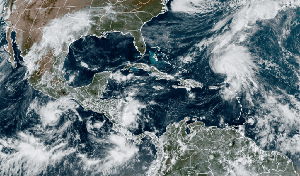
NOAA/Colorado State University/RAMMB 10/23/23 12:50 pm CDT
Bob
Social Media