Dry Weather Pattern Continues this Week. Temperatures Look to Heat Up Once Again
OCT. 16, 2023
What an amazing weekend of fall weather! After such an extreme and long summer, these recent cool temperatures have been nothing short of amazing. Readings early Monday morning were the coolest readings we’ve seen since early April. According to LCRA’s Hydromet, lows ranged from the upper 30s to mid-40s across the Hill Country, to the low and mid-50s across the coastal plains. Several spots across the western Hill Country saw temperatures dip into the mid-30s. The Hydromet’s lowest observed reading Monday morning was a chilly 34 degrees at locations in Menard and northern Edwards Counties.
A dry and very stable fall-like weather pattern has developed across the region in the wake of Friday’s cold front. Monday’s weather maps shows a large dome of Canadian high pressure stretching from southern Canada, across Texas and down to central Mexico. The dome of high pressure brought with it a large mass of cool, dry air. The atmosphere overall is dry and quite stable. As a result, the sky is forecast to be sunny throughout the week with no rain.
The pleasant fall-like weather will continue this afternoon through Wednesday, before westerly breezes bring a return of warmer temperatures Thursday and Friday.
- High temperatures this afternoon will be in the low and mid-70s. Highs are predicted to warm to the upper 70s Tuesday, and the lower 80s Wednesday.
- Lows Tuesday morning will include the mid-40s across the Hill Country and Central Texas, with mid and upper 40s across the coastal plains.
- Lows Wednesday morning are forecast to be in the upper 40s to low 50s.
- Lows Thursday morning will range from the mid-50s west, to the low 60s near the coast.
Forecasts call for a weak Pacific cold front to spread southeast across the area Thursday. Previous forecasts had called for a chance for rain to develop late week, but it appears now no rain will develop with the front due to so little moisture in place. The front will shift winds out of the west and reinforce the very dry air already in place. Interestingly, warmer and almost summer-like temperatures are forecast to develop behind the cold front Thursday and through the weekend due to the Pacific nature of the air mass.
- High temperatures Thursday are forecast to be generally be in the upper 80s. Highs are forecast to be near 90-92 degrees Friday and Saturday, then lower close to 88-90 degrees on Sunday.
- Lows Friday through Monday mornings are forecast to be in the upper 50s to low 60s.
Some changes in the weather pattern are forecast for next week.
Forecasts call for a Pacific trough of low pressure to track across the northern half of Texas out of the Desert Southwest Tuesday into Wednesday. This system is expected to bring a chance for rain showers and thunderstorms to the region next Tuesday and Wednesday. As of now, rain amounts are forecast to generally average less than a half inch. This will be followed by dry weather next Thursday and Friday. Temperatures look to be warm all of next week, with highs in the 80s, and lows in the 60s.
Tropical Weather Update
Weather conditions remain quiet across the Gulf of Mexico and there are no systems in place which pose a threat for tropical development over the next seven days.
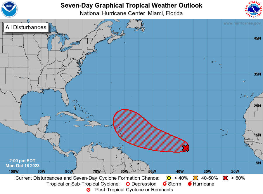
Out across the central tropical Atlantic, forecasters continue to monitor a broad area of low pressure located about midway between the Windward Islands and western Africa. This system is producing a large area of disorganized showers and thunderstorms. Satellite data indicates that the low-level circulation continues to become better defined and, since environmental conditions are expected to remain conducive for further development, a tropical depression is likely to form within a few days. This system is forecast to move westward to west-northwestward across the central and western tropical Atlantic during the next several days, posing no threat to the Gulf of Mexico.
NHC forecasters are giving this system an 80 percent chance for tropical development over the next seven days.
Have a good week.
Bob
Social Media