Sunny, Dry, and Fall-Like through the Middle of Next Week
OCT. 13, 2023
A dry and quiet weather pattern continues across Central and South Texas as we close out the workweek. All eyes are on a cold front that will push through the area Friday afternoon and evening, that will bring more cool, fall-like air for the weekend and the first half of next week. As of early Friday afternoon, the front stretched from east of Dallas, to Waco, Llano, and Junction. The cold front is predicted to move across Central Texas this afternoon, the coastal plains region this evening, then move out into the Gulf of Mexico late Friday evening. Although one or two isolated rain showers will be possible along the cold front, no widespread rain is expected. Ahead of the cold front, temperatures across Central Texas and the middle Texas coast are predicted to warm close to 90 degrees. For areas behind the cold front, afternoon temperatures are forecast to hold in the upper 70s to mid-80s.
Clear, cooler, and breezy weather can be expected Friday night through Saturday as a large dome of high pressure spreads south behind the cold front. Expect northerly winds at 10-15 mph, with gusts up to 25 mph.
- Lows Saturday morning will range from the low and mid-50s across the Hill Country, to the low 60s near the coast.
- High temperatures Saturday are forecast to be in the upper 70s.
- Lows Sunday morning will range from the upper 40s across the Hill Country, to the mid-50s near the coast.
The sky is expected to be mostly sunny Saturday, providing near perfect conditions to see the annular eclipse. Some thin, cirrus clouds will be possible, but they shouldn’t be thick enough or widespread enough to interfere. An astute observer Saturday may notice the brightness will not be quite what it should be at noon – more like the intensity of the sun`s rays after sunrise or before sunset. Those planning to view the eclipse should use proper solar/eclipse glasses (specifically those that meet ISO 12312-2 requirements). Optical devices like cameras, binoculars, and telescopes will also require their own solar filters for safe eclipse viewing (eclipse glasses alone will NOT protect you when using these devices).
Visit earthsky.org/sun/annular-solar-eclipse-october-14-2023 for more information.
Sunday through next Wednesday, weather conditions are shaping up to be sunny, dry, and fall-like as a stable ridge of high pressure spreads across Texas out of the Southwestern U.S. We should see mild daytime temperatures and cool readings at night.
- High temperatures Sunday and Monday are forecast to be in the mid-70s.
- Lows Monday, Tuesday, and Wednesday mornings will include the mid-40s across the Hill Country, in the upper 40s to 50 degrees across Central Texas, and be near 50-52 degrees across the coastal plains.
- High temperatures Tuesday and Wednesday are predicted to be in the low and mid-80s.
Changes in the weather pattern are forecast to take place late next week when a large trough of low pressure moves from the central Rockies to the southern Plains, dragging a Pacific cold front with it. Gulf moisture looks to return Thursday ahead of the cold front. This may result in a few scattered rain showers and thunderstorms. A better chance for rain showers and thunderstorms is predicted for next Friday when the trough and cold front move across the area. Rain amounts are still somewhat uncertain due to differing solutions among the global forecast models. As of now, the consensus seems to be for totals to average around a half inch.
Dry and just slightly cooler weather will follow the cold front next weekend, continuing into the week of October 23rd. Expect high temperatures to be near 80-82 degrees, with lows in the 50s.
Tropical Weather Outlook
Weather conditions are quiet across the Gulf of Mexico and the Caribbean Sea. Tropical development is not expected in this area over the next week.
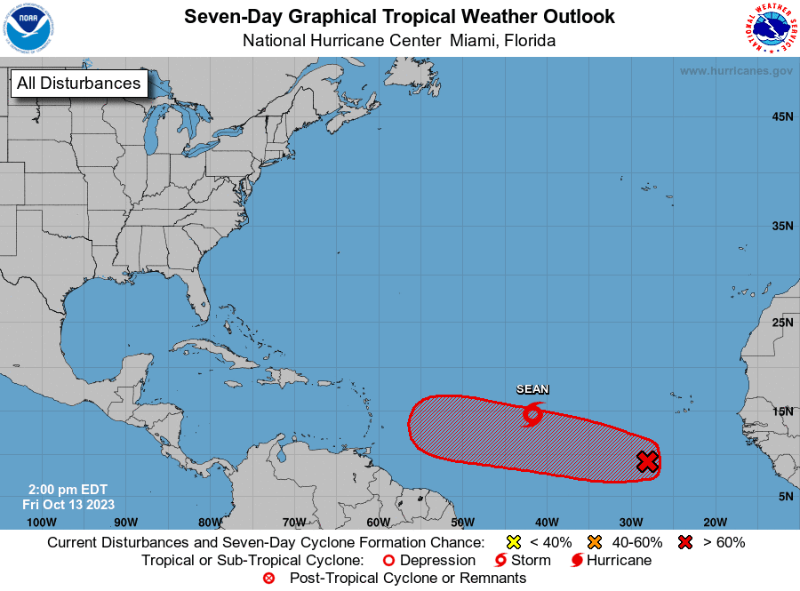
The National Hurricane Center is monitoring the progress of Tropical Storm Sean, located over the central tropical Atlantic, about 1180 miles west of the Cabo Verde Islands. Maximum sustained winds have recently decreased to near 40 mph, with higher gusts. Additional weakening is anticipated and Sean will likely become a post-tropical remnant low over the weekend.
Forecasters are closely monitoring a broad area of low pressure located several hundred miles south-southwest of the Cabo Verde Islands. This system is producing a large area of disorganized showers and thunderstorms. Environmental conditions are expected to become more conducive for development by the end of the weekend while the disturbance begins to move westward across the central tropical Atlantic. Additional development is expected after that, and a tropical depression is likely to form during the early to middle portion of next week as the system moves steadily westward across the central and western tropical Atlantic. NHC forecasters are giving this system an 80 percent chance for tropical development over the next seven days.
Have a great weekend!
Bob
Social Media