Weather conditions were spectacular over the weekend and fall was definitely in the air! The temperature dropped into the 50s across the entire region Sunday and Monday mornings, with several Hill Country locations seeing lows in the 40s. According to LCRA’s hydromet, the lowest temperature observed Monday morning was 45 degrees, at locations along the North and South Llano Rivers, in Sutton and Edwards Counties.
We’re looking at a fairly quiet week of weather this week as this weekend’s cool air mass slowly pulls away from our area. Interestingly, the biggest influence on our weather this week will be from tropical storms, Lidia and Max, located off the coast of Mexico, in the eastern tropical Pacific. Strong westerly winds in the upper atmosphere to the north of the two systems is currently pulling a large area of middle and high-level clouds from these systems east-northeastward across northern/central Mexico and South Texas.
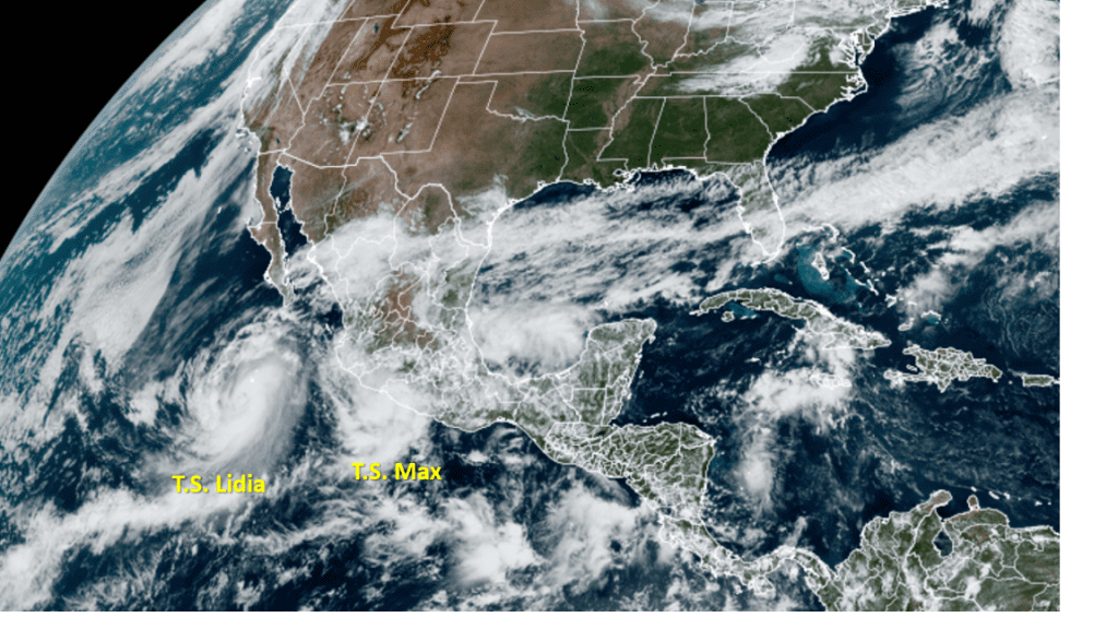
NOAA/Colorado State University/RAMMB 10/09/23 1:20 pm CDT
Tropical Storm Lidia, the western most storm, is forecast to strengthen into a hurricane later today. Lida is moving to the east-northeast and is expected to move inland along the west-central coast of Mexico late Tuesday. Meanwhile, Tropical Storm Max recently made landfall along the southern coast of Mexico, about 30 miles southeast of Zihuatanejo. The remnants of Max are forecast to spread inland across southern Mexico today and Tuesday.
The remnant mid-level circulation of both systems is forecast to be pulled northeastward and move across Deep South Texas late Tuesday into Wednesday, resulting in widespread clouds and areas of light rain. Based on the forecast trajectory and movement of the circulation centers, the heaviest rains look to stay across South Texas, over the area generally to the south of Interstate 10.
For this afternoon, expect a sunny sky with high temperatures in the mid-80s.
Tonight, clouds are predicted to expand to the north and cause our sky to become mostly cloudy. Lows Tuesday morning will generally be in the low and mid-60sd.
Tuesday, expect a mostly cloudy to overcast sky across the region as clouds and moisture spread northeast in advance of the remnant storm systems. There will be a slight chance for a few scattered light rain showers across the area Tuesday afternoon. Expect a high temperature in the upper 70s.
The chance for light rain is predicted to increase to around 30-40 percent Tuesday night into Wednesday morning. Again, the most favorable area for significant rain is expected to occur to the south of Interstate 10. The chance for rain is expected to end from west to east Wednesday afternoon as the remnants exit to the northeast. High temperatures Wednesday are forecast to be near 78-80 degrees.
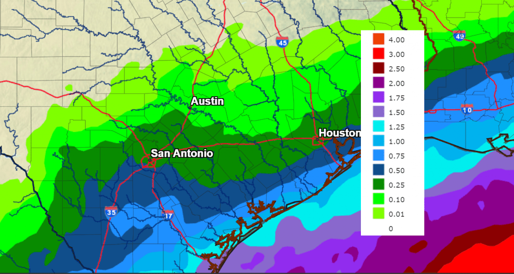
Rainfall Tuesday through Wednesday is forecast to be very light across the Hill Country. Totals across most of Central Texas are forecast to average near or less than a quarter inch. To the south of Interstate 10, totals are forecast to range from 0.25-0.50 inches to near 1 inch along the coast.
NWS Rainfall Forecast for the Period 7 pm Monday through 7 pm Wednesday:
The sky is predicted to become mostly sunny Thursday. Temperatures do look to trend warmer, with highs in the upper 80s.
The next weather changes is expected to take place Friday morning when a cold front moves southeast across the area. As of now, little to no rain is expected with the cold front. Breezy and cooler weather looks to follow Friday afternoon. In advance of the front, expect high temperatures in the mid to upper 80s.
Sunny, dry, and fall-like weather will follow the cold front this weekend. Expect high temperatures in the 70s to near 80 degrees, with lows in the 50s.
The outlook for next week calls for continued sunny, dry, and mild weather. High temperatures will be in the low and mid-80s, with lows in the 50s and 60s. A chance for rain is forecast to develop sometime late next week.
Tropical Weather Outlook
Shower and thunderstorm activity has changed little in organization in association with a small area of low pressure over the southwestern Gulf of Mexico. Environmental conditions appear only marginally favorable for some additional development while the system moves slowly northward before the low merges with a frontal system over the western Gulf of Mexico by midweek. The probability for tropical develop is 20 percent over the next 7days. This system is predicted to merge with the front system and move northeast toward the central Gulf coast.
Out in the eastern tropical Atlantic, a low-latitude tropical wave was located several hundred miles south-southwest of the Cabo Verde Islands. This system continues to produce a large area of showers and thunderstorms. This activity has become a bit more concentrated this afternoon, and environmental conditions appear conducive for additional development of this system during the next several days. A tropical depression is likely to form in the next couple of days while it moves west-northwestward or northwestward across the eastern tropical Atlantic. NHC forecasters give this system an 80 percent chance for tropical development over the next seven days.
Bob
Social Media