Wednesday is going to our last really warm day for a while, and possibly for the year. Today’s high temperature is forecast to be in the low and mid-90s across the Hill Country and Central Texas regions, and in the upper 80s towards the coast.
The chance for scattered rain showers and thunderstorms will be increasing across our region tonight and into Thursday ahead of a much anticipated cold front. As of early this afternoon, the front stretched from eastern Kansas, to near Amarillo, to Albuquerque. Out ahead of the cold front, the atmosphere is moist and slightly unstable. The latest high resolution forecasts call for the cold front to push southeast this afternoon and evening, reaching the northern Hill Country around 3 am Thursday morning. The front is predicted to continue southeast and move through the Austin area around 6 or 7 am Thursday morning, reaching the coastal plains region late Thursday morning and toward midday.
For this afternoon and evening, there will be a slight chance for a few scattered showers and thunderstorms across the Hill Country and Central Texas as Gulf moisture continues to increase. Spotty totals should stay below a quarter inch. In contrast, the chance for rain showers and scattered thunderstorms will be high across the middle Texas coastal plains, where a plume of tropical moisture is currently moving inland across Southeast Texas. Slow-moving showers and storms have already developed across the area, with the activity slowly tracking to the north-northeast. According to LCRA’s Hydromet, one of the heavier showers produced 1.58 inches of rain at Bay City between 11:30 am and 1 pm.
The National Weather Service has posted a Flood Watch for Wharton and Matagorda Counties until 7 pm Wednesday evening. Here, total of 1-2 inches will be possible through the evening as additional slow-moving storms move across the area. This area of rain is forecast to weaken late evening and toward midnight.
All eyes will be on the cold front as it sinks southeast overnight through Thursday. Forecasts call for a widespread area of rain showers and thunderstorms to develop along and behind the cold front as it pushes to the south. A couple of strong storms with gusty winds and small hail will be possible, but the threat for widespread severe storms appears low. A good chance for light to moderate rain showers looks to continue behind the cold front Thursday morning and Thursday afternoon. This will be followed by occasional light rain showers with a couple of isolated thunderstorms Thursday night into Friday morning. The chance for rain is expected to diminish across the Hill Country and Central Texas regions Friday morning, and across the middle Texas coast Friday afternoon.
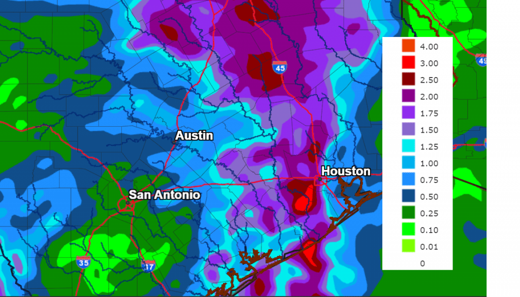
Forecasted rain amounts with the cold front have unfortunately decreased from earlier projections. The latest forecasts for rain between Wednesday evening and Friday evening across the Hill Country call for totals to average between 0.25 and 1 inches. Across Central Texas, totals of 0.5 to 1.5 inches are forecast. And across the middle Texas coast, totals of 1-3 inches are forecast.
NWS Rainfall Forecast for the Period 7 pm Wednesday through 7 pm Friday:
The other big story with the approaching cold front will be the change to cooler and more autumn-like weather. A second, dry cold front late Friday is expected to bring a push of noticeably cooler air for the weekend and early next week. A mostly sunny sky is forecast Saturday through Sunday.
- Friday’s high temperature is forecast to be mostly in the mid and upper 80s.
- Lows Friday morning will range from the low 60s across the Hill Country to near 70 degrees near the coast.
- High temperatures Friday are forecast to be in the low and mid-80s.
- High temperatures Saturday and Sunday are forecast to be in the low and mid-70s.
Lows Saturday and Sunday mornings will range from the upper 40s and low 50s across the Hill Country, to the low and mid-50s across Central Texas and the middle Texas coast.
Enjoy the rain and the change to cooler weather!
Bob
Social Media