Big changes in the weather pattern are still on track to take place mid and late week as the first significant cold front of autumn sweeps through the area. The front is expected to bring noticeably cooler temperatures and finally put an end to the persistent summer pattern. At the same time, the front will help bring our region widespread, soaking rains—mainly Wednesday through Thursday.
As we start off the new week and new month, a our region remains under the influence of a large heat dome that stretches from central Mexico to the Great Lakes. To the west of the heat dome, a large trough of low pressure is located across the western U.S. This trough will be in catalyst for our big weather changes later this week. Forecasts call for the trough to push east across the Plains states Wednesday into Thursday. It’s this trough that will help push a fairly strong cold front across Texas late Wednesday through Thursday. Moisture spreading north from the Gulf ahead of the trough is expected to cause a favorable environmental set up for the development of rain showers and thunderstorms ahead of, along, and behind the cold front.
For Monday afternoon and Monday Night
Expect a mostly sunny to partly cloudy sky. No rain is forecast across the Hill Country or Central Texas regions. A few widely scattered rain showers will be possible towards the coast. High temperatures will generally be in the low and mid-90s.
Tuesday through Tuesday Night
Partly cloudy and warm weather will continue. However, the chance for scattered rain showers will begin to increase across region as an area of enhanced moisture spreads inland from the Gulf. High temperatures are forecast to be near 90-92 degrees.
Across the coastal plains, there will be a 70 percent chance for rain showers throughout the day, lowering to 50 percent Tuesday night.
Across Central Texas and Hill Country, there will be a 20 percent chance for scattered rain showers and isolated thunderstorms Tuesday afternoon, increasing to a 40 percent chance Tuesday night.
Wednesday through Wednesday Night
Expect a mostly cloudy to overcast sky Wednesday as another surge of Gulf moisture spreads north across the area. Showers and scattered thunderstorms will increase in areal coverage across the region Wednesday afternoon into Wednesday night as the atmosphere becomes increasing unstable ahead of the approaching trough. Some of the thunderstorms may be strong to severe late Wednesday into Wednesday night, capable of producing large hail and damaging winds. The probability for rain will be 80-90 percent Wednesday afternoon and Wednesday night. High temperatures Wednesday are forecast to be around 90 degrees.
Thursday through Thursday Night
Forecasts call for the Pacific cold front to reach the northern Hill Country shortly after sunrise Thursday. The front is predicted to push south across Central Texas and the middle Texas coast Thursday morning through Thursday afternoon, then move off the coast Thursday night. Widespread rain showers and scattered thunderstorms are forecast along and behind the cold front Thursday through Thursday night. Some of the rain may at times be moderate to heavy in intensity. A few areas may see some localized urban and small stream flooding. Totals Thursday through Thursday night are forecast to average between 1 and 2 inches.
The temperature will turn cooler behind the cold front, with high temperatures in the upper 70s to low 80s. The coastal area will still be warm, with highs in the upper 80s.
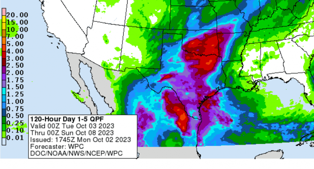
Rain Amounts
Some significant totals of rain are forecast this week. The National Weather Service’s rainfall forecast through Saturday calls for widespread amounts of 1-3 inches, with some isolated totals to near 5 inches possible.
NWS Rainfall Forecast for the Period 7 pm Monday through 7 pm Saturday:
Friday through Friday Night
Expect a mostly cloudy as moisture continues to overrun the frontal boundary. There will be a 30-40 percent chance for scattered light rain showers through Friday afternoon, with the rain tapering off from north to south Friday night.
High temperatures Friday are forecast to be in the upper 70s, with lower 80s near the coast.
Lows Saturday morning will range from the upper 50s across the Hill Country, to the mid-60s near the coast.
This Weekend
A mostly sunny to partly cloudy sky is forecast.
High temperatures both days are predicted to be in the upper 70s to low 80s.
Low temperatures Sunday and Monday mornings will generally be in the mid and upper 50s.
Next Week
The outlook for next week is calling for mostly sunny and dry weather, with mild temperatures. Expect high temperatures generally in the mid-80s, with lows in the low and mid-60s.
Tropical Weather Outlook
Weather conditions are quiet across the Gulf of Mexico and the Caribbean Sea. There are no systems in place which pose a threat for development over the next seven days.
In the tropical Atlantic, The National Hurricane Center is issuing advisories on Tropical Storm Philippe, located just east of the Leeward Islands. This system is moving to the north and poses no threat to the Gulf. Tropical Storm Rina dissipated over the weekend.
Bob
Social Media