Widespread Rain and Cooler Temperatures Expected Late Next Week
SEPT. 29, 2023
Although it’s late September, this week’s weather has felt more like August, with the temperature reaching the mid and upper 90s. This summer’s strong heat dome has persisted across Texas throughout September, and this has lead to one of the warmest Septembers on record. But finally, there are signs the heat dome will begin to weaken and move away from Texas next week, allowing a significant cold front to bring widespread rain and cooler temperatures. While readings will be noticeably lower, nothing drastic is expected. The latest forecasts are pointing to the potential for significant totals of rain late in the week.
Friday Afternoon and this Weekend
More summer-like weather can be expected as the heat dome remains over Texas. With a mostly sunny to partly cloudy sky, daily high temperatures will include the low 90s across the coastal plains, and mid to upper 90s at most other locations.
The coastal plains region will see a daily chance for scattered rain showers and thunderstorms as a weak trough of low pressure and an enhanced area of tropical moisture pushes inland off the western Gulf of Mexico. The probability for rain each day is predicated to be near 40-50 percent. Daily rain amounts are forecast to average less than a quarter inch.
For Central Texas and the eastern Hill Country, the enhanced area of tropical moisture pushing inland will bring a very slight chance for a few scattered afternoon rain showers Saturday and Sunday. The probability for rain will only be 20 percent. Little to no rain is expected.
For the western and central Hill Country, no rain is forecast through the weekend.
Monday through Tuesday
Warm temperatures will continue. However, with the heat dome beginning to weaken and a fair amount of tropical moisture spreading inland off the Gulf, scattered mainly afternoon and evening rain showers and thunderstorms are forecast across the region. In addition, scattered thunderstorms are forecast to develop across parts of West Texas each day, and some of these storms could reach the western Hill Country in the late afternoon and evening hours. The probability for rain each day will near 30 percent. Daily rain amounts should average well below a quarter inch. High temperatures both days are forecast to be in the low to mid-90s.
Wednesday and Thursday
Changes in the weather pattern are forecast to take place these two days as a large trough of low pressure pushes into central and northern Plains out of the Rockies. This trough will help push a fairly strong cold front south into Texas. The latest projections call for the cold front to reach northwestern Texas late Wednesday night, then push south across the Hill Country, Central Texas, and middle Texas coast Thursday morning into Thursday afternoon.
Forecasts call for an increasing chance for rain showers and thunderstorms across the region Wednesday afternoon and Wednesday night ahead of the cold front. Some strong thunderstorms will be possible. Widespread rain showers and thunderstorms are forecast throughout the day Thursday, continuing into Thursday night as the cold front tracks to the south. The rain is predicted to taper off from north to south late Thursday night into Friday morning as drier and cooler air spreads in behind the cold front.
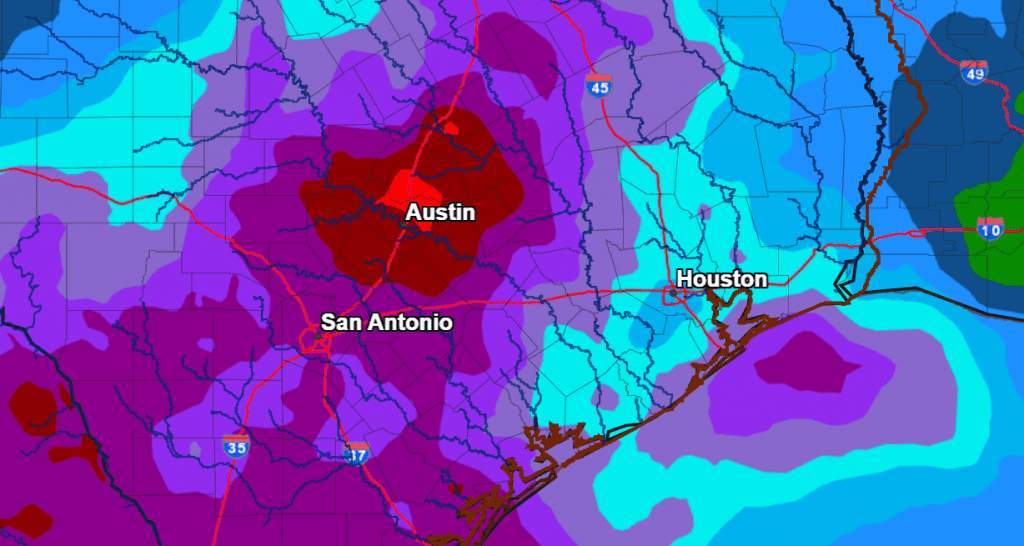
Recent rainfall forecasts have trended higher in regards to the rain Thursday into Thursday night. The forecast shows the potential for significant rain to fall, with the heaviest rains expected to fall across the eastern Hill Country and much of Central Texas. The National Weather Service’s rainfall forecast for Thursday into Friday calls for totals of 1.5 to 2 inches across the western and central Hill Country, and totals of 2-3 inches across the eastern Hill Country and much of Central Texas. Across the coastal plains, totals of 1-2 inches are forecast.
NWS Rainfall Forecast for the Period 7 pm Wednesday through 7 pm Friday:
The rain is forecast to taper off Friday morning, followed by a partly to mostly cloudy sky Friday afternoon. Sunny and dry weather is expected next weekend.
The temperature will trend cooler behind the cold front beginning Thursday.
- High temperatures Thursday are forecast to be in the mid and upper 80s.
- Low temperatures Friday morning are forecast to be in the mid and upper 60s.
- High temperatures next Friday and next weekend are forecast to be in the low and mid-80s.
- Lows next Saturday and Sunday mornings are forecast to be in the low and mid-60s.
Looking out into the week of October 9th, generally dry and mild weather is forecast to continue, with high temperatures holding in the mid and upper 80s.
Tropical Weather Outlook
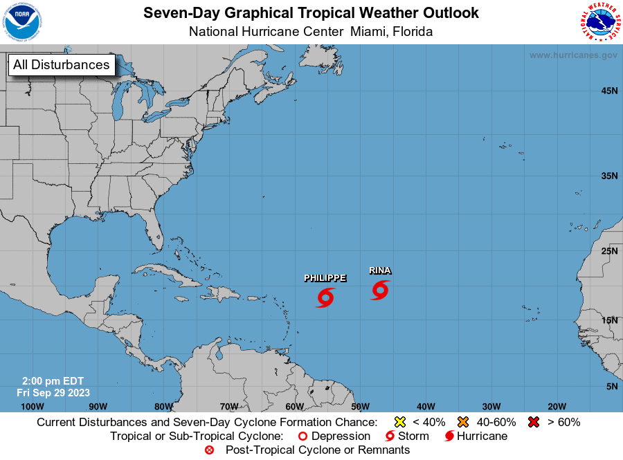
Weather conditions are quiet across the Gulf of Mexico and the Caribbean Sea. Tropical cyclone development is not expected across this area over the next seven days.
Out in the tropical Atlantic, The National Hurricane Center is issuing advisories on Tropical Storm Philippe, located several hundred miles east of the northern Leeward Islands, and on Tropical Storm Rina, located over the central tropical Atlantic. Neither system poses a threat to the Gulf of Mexico.
Harvest Moon Will Still be Big and Bright Friday Night
The Harvest Moon will shine again very bright Friday night. In addition to this being the Harvest moon, it will also be a Supermoon, appearing 5 percent bigger and 13 percent brighter than usual.
Be sure to watch the sky Sunday night when the waning gibbous Moon will rise in the east-northeast around the end of twilight. Ten or fifteen minutes later, Jupiter will rise and be just 2° or 3° to the Moon’s lower right. The two will shine very close to each other all night and should be quite a pair!
Have a good weekend!
Bob
Social Media