The much anticipated change in the weather is finally taking place across Central and South Texas. The heat dome, which has persisted across Texas since June, is finally weakening and sinking to the southwest. Monday’s analysis showed the center of the heat dome now off the coast of Baja, California. With a much weaker heat dome now in place, it’s opened the door for less hot temperatures and chances for rain. Winds in the middle and upper atmosphere across Texas are now flowing east-southeast out of New Mexico, along the northern periphery of the heat dome. Occasional waves of low pressure riding along these winds are expected to cause the development off scattered rain showers and thunderstorms each day this week. However, the highest probability for rain is forecast to occur late Thursday through Saturday.
Scattered light rain showers occurred across parts of the northern Hill Country Monday morning as an outflow boundary pushed southeast out of West Texas. According to LCRA’s Hydromet, most totals were generally less than a quarter. All of these showers are predicted to diminish Monday afternoon as they move into a more stable atmosphere. A mostly sunny to partly cloudy sky is forecast. Monday’s temperature is forecast to climb to the mid and upper 90s.
The chance for rain showers and scattered thunderstorms is forecast to increase across the northern and central Hill Country and the northern counties of Central Texas late Monday evening into Monday night when an upstream wave of low pressure helps push a weak cold front southeast out of West Texas. High resolution forecasts call for an area of showers and thunderstorms to develop across the Concho Valley and Heartland regions late this evening, with the activity slowly expected to move into the Hill Country after midnight. Some of the thunderstorms may strong or severe, possibly producing large hail and damaging winds. The Storm Prediction Center has placed the area generally west of a Goldthwaite, to Llano, to Kerrville line under a marginal risk for severe storms. There’s a slight chance some of the rain and storms could make into the Austin/Interstate 35 corridor before sunrise Tuesday. Totals from the overnight storms will range from around an inch across the northwestern Hill Country, to a tenth of an inch in the Austin area. Elsewhere, no rain is forecast.
Tuesday through Wednesday, forecasts call for just a slight chance for rain showers and thunderstorms across the Hill Country and Central Texas regions—mainly in the afternoon and evenings. The weak cold front across West Texas is predicted to slowly sink southeast into Central Texas Tuesday night into Wednesday. The probability for rain both days will be near 20 percent. Expect a mostly sunny to partly cloudy sky. High temperatures both days will range from near 90 degrees across the northern Hill Country, to the mid-90s across Central Texas, to the upper 90s across the coastal plains. Rain amounts, if any, should total less than a quarter inch.
Forecasts point toward increased chances rain showers and scattered thunderstorms across the entire region beginning Thursday and continuing through Saturday. The cold front is predicted to sag south into South Texas. At the same time, a series of waves of low pressure are forecast to track southeast out of New Mexico. With abundant moisture in place, waves of rain showers and scattered thunderstorms are forecast to move across the entire region between Thursday morning and Saturday evening. Some locally heavy rain will be possible. Some light rain may linger into Sunday, before a drier pattern takes hold Sunday afternoon into Sunday night.
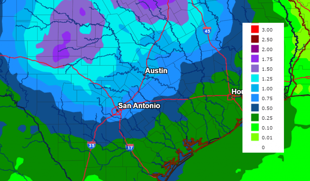
The National Weather Service’s Rainfall outlook for the period 7 pm Thursday through 7 pm Saturday calls for widespread totals of around 1-1.5 inches across the Hill Country and Central Texas regions, and between 0.25 and 0.5 inches across the middle Texas coast.
Less hot temperatures are predicted late week and into the weekend. Daily high temperatures will range from around 88-90 degrees across the northern Hill Country, to the mid-90s across the coastal plains.
The outlook for next week calls for sunny, dry, and warm weather as a weak heat dome spreads back across Texas. Daily high temperatures are predicted to hold mostly in the mid-90s.
Tropical Weather Outlook
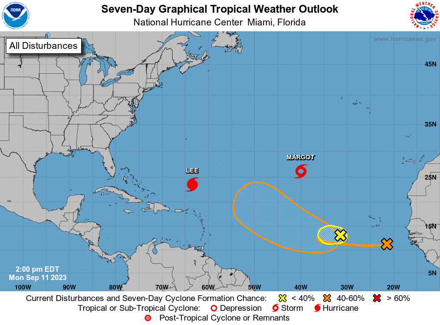
Weather conditions are quiet across the Gulf of Mexico and the Caribbean Sea. There are no systems which pose a threat for tropical development over the next seven days.
The National Hurricane Center is closely monitoring Hurricane Lee, located a few hundred miles north of the northern Leeward Islands, and on Tropical Storm Margot, located over the central subtropical Atlantic.
NHC forecasters are also following a tropical wave located over the far eastern tropical Atlantic, between the Cabo Verde Islands and the west coast of Africa. This system is producing disorganized showers and thunderstorms. Environmental
conditions do appear conducive for gradual development of this system, and a tropical depression could form by the weekend while it moves westward to west-northwestward at 15 to 20 mph over the central tropical Atlantic. Forecasts call for this system to bend northwest into open Atlantic and it should not pose a threat to the Gulf of Mexico.
Have a good week.
Bob
Social Media