Summer Refusing to Give Up. Expect More Dry and Very Hot Weather into Next Week
SEPT. 1, 2023
Well, we survived one of the hottest summers on record! Preliminary data indicates summer 2023 was the second hottest summer on record for Texas, behind 2011. However, individual sites such as Austin-Bergstrom Airport, San Antonio, Victoria, Llano, and Junction all recorded their hottest summers on record.
Summer 2023 was also one of the driest summers on record. Data shows Austin-Camp Mabry recorded only 1.31 inches of rain since June 1st, making this the second driest summer on record. Llano recorded 1.24 inches, ranking as the 7th driest summer on record. Even toward the coast, Columbus measured only 2.60 inches since June 1st, ranking as the third driest summer total on record.
Any way you look at it, it’s been a rough three months. And although we’ve now turned the calendar to September, it’s still going to still feel a lot like August for a quite a while yet. This summer’s heat dome, fueled by the “Energizer Bunny,” is not showing any signs of backing down over the next couple of weeks. While the chances of seeing temperatures above 105 degrees appear low, readings of 100-105 degrees do look to continue into the middle of the month. Unfortunately, with the heat dome remaining in place, little to no rain is forecast over the next couple of weeks.
Heading into the holiday weekend, no significant changes in the hot and dry weather pattern are expected. Friday’s analysis did show a small area of low pressure in the middle and upper atmosphere located over East Texas and Louisiana. This low is not tropical in nature. Forecasts call for the low to track a little further west into Texas this weekend, then lift north into Oklahoma late Monday. The low is expected to pull tropical moisture inland beginning Sunday across Southeast Texas, with the moisture extending as far west as about Interstate 35. The increased moisture will help support the potential for widely scattered afternoon showers and thunderstorms across the coastal plains and parts of Central Texas east of I-35 Sunday and Labor Day. The probability for rain both days will range from 40 percent across the coastal plains, to just 20 percent further inland. Rain amounts, if any, are forecast to average between a tenth and a quarter inch.
No rain is forecast for the Austin area and locations west into the Hill Country Sunday through Monday.
Generally speaking, weather conditions Friday afternoon through Monday will feature a sunny sky and very hot temperatures. High temperatures are forecast to be near 100-103 degrees. Light southeasterly winds at 5-10 mph are forecast Friday through Sunday.
For next Tuesday into next weekend, the sunny, dry and very hot weather looks to continue as the center of the heat dome slides a little further to the east out of the Desert Southwest. A few scattered afternoon rain showers will still be possible across the coastal area Tuesday and Wednesday, but the chance for rain will diminish late next week. High temperatures are forecast to continue near 100-103 degrees.
For the week of September 11th, forecasts call for few change as the heat dome continues across Texas and northern Mexico. High temperatures look to continue near 100-103 degrees.
Fire Weather Concerns
Dry to critically dry fuels continue across the Hill Country and Central Texas and with no significant rain in the forecast, near critical fire weather conditions can be expected this weekend and next week. Everyone is urged to exercise care with respect to all outdoor activities that could inadvertently cause wildfires. Avoid the use of welding or grinding equipment near grass and dry brush. In addition, avoid parking vehicles in tall, dry grass and weeds that could be ignited.
Do not toss cigarette butts on the ground. Report wildfires quickly to the nearest fire department or law enforcement office.
Tropical Weather Outlook
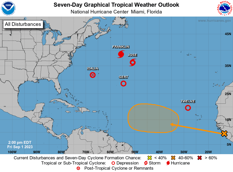
Weather conditions are quiet across the Gulf of Mexico and the Caribbean Sea. Tropical cyclone development is not expected in this area for at least the next seven days.
Across the Atlantic, the National Hurricane Center is closely following Hurricane Franklin, located about 680 miles northeast of Bermuda, Tropical Storm Jose, located about 835 miles east-northeast of Bermuda, Tropical Depression Gert, located roughly 655 miles east-southeast of Bermuda, and the remnants of Idalia, located 185 miles west of Bermuda.
A new tropical depression developed Friday morning over the eastern tropical Atlantic, about 375 miles northwest of the Cabo Verde Islands. The depression was moving toward the north-northwest near 8 mph. A motion toward the north-northwest and northwest at a faster forward speed is expected through Sunday. A turn toward the west-northwest is forecast later on Sunday. Maximum sustained winds are near 35 mph with higher gusts. Some strengthening is expected, and the depression is forecast to become a tropical storm Friday evening. The system is likely to weaken early Sunday and degenerate to a remnant low by late Sunday.
Finally, NHC forecasters indicate a tropical wave is expected to move off the west coast of Africa this weekend. Environmental conditions appear conducive for some gradual development of this system during the early and middle parts of next week, and a tropical depression could form while it moves westward to west-northwestward over the eastern and central portions of the tropical Atlantic.
Have a safe and enjoyable holiday weekend! For those spending time outdoors, make sure to stay safe in the heat; stay hydrated and take frequent breaks in the shade or indoors with A/C.
Bob
Social Media