A Chance for Showers Monday. Next Week is Not Expected to be Quite as Hot
AUG. 25, 2023
The summer heatwave drags on, with no significant relief expected anytime soon.
Thursday turned out to be the hottest day of the summer for the coastal plains region, where the temperature reached between 105 and 107 degrees across the area between La Grange and Bay City. These readings were just shy of the all-time record high temperatures. Across the Hill Country and Central regions, Thursday’s temperature also climbed to between 105 and 107 degrees, but hotter readings have been recorded earlier in the summer.
Mostly sunny and very hot weather will continue this afternoon through Sunday as the summer heat dome continues to heavily influence our weather. After spending nearly a week over the Midwest, the center of the heat dome will be moving back to the south and southwest. Forecasts call for the center of the heat dome to be over Oklahoma this weekend, then move to the Desert Southwest early next week. Heat Advisories and Excessive Heat Warnings will continue into the weekend.
- High temperatures Friday through Sunday are forecast to be between 104 and 107 degrees across the Hill Country and Central Texas regions, and between 103 and 106 degrees across the coastal plains.
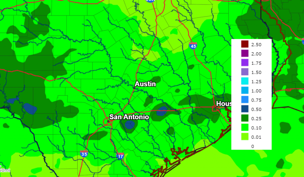
There will be a very slight chance for a few scattered rain showers and isolated thunderstorms across the region Friday through Sunday. Forecasts call for some small waves of low pressure to rotate around the base of the heat dome and track from east to west across Central Texas and the Hill Country. In addition, slightly higher moisture levels are also forecast to be in place across the region. Both factors are expected to help with the development of afternoon scattered rain showers and isolated thunderstorms. The probability for rain will only be 20 percent, and for locations that do see rain, totals are forecast to only average around a tenth of an inch.
There will be a somewhat better chance for scattered rain showers and thunderstorms taking place across the Hill Country and Central Texas regions Monday into Monday evening, and across the coastal plains region Tuesday into Tuesday evening when a weak cold front slides south out of the southern Plains. Forecasts call for the cold front to reach the northern Hill Country early Monday morning, then slowly slide south across Central Texas Monday afternoon into Monday evening. The front is forecast to move across the middle Texas coast Tuesday into Tuesday evening. Moisture convergence along and behind the cold front is expected to cause the development of scattered rain showers and thunderstorms. The probability for rain will be between 30 and 50 percent. Rain amounts with the front are forecast to generally average around a quarter inch or less. Unfortunately, the coverage of precipitation looks to remain scattered enough that some areas may miss out on the rain.
The rain is forecast to taper off from north to south across Central Texas Monday into Monday evening, and across the coastal plains region Tuesday into Tuesday evening. Sunny and dry weather is forecast next Wednesday through Friday.
NWS Rainfall Forecast for the Period 7 am Friday through 7 am Wednesday:
“Slightly” lower temperatures are forecast behind the cold front next Tuesday through Friday.
- High temperatures Monday are forecast to be between 100 and 105 degrees across the entire region.
- High temperatures next Tuesday through Friday are forecast to be in the upper 90s across the Hill Country and the coastal plains, and near 98-102 degrees across Central Texas.
Looking out to next weekend and the week of September 4th, forecasts call for a mostly sunny, dry, and hot weather pattern as the heat dome returns to Texas and the southern Plains states. A few sea breeze showers will be possible, but the overall pattern looks dry. High temperatures through the period are predicted to be between 102 and 104 degrees across the Hill Country and Central Texas regions, and between 98 and 102 degrees across the coastal plains.
Tropical Weather Outlook
The National Hurricane Center is closely monitoring a broad area of low pressure located over the northwestern Caribbean Sea that is producing a disorganized area of showers and thunderstorms. Environmental conditions appear conducive for gradual development of this system during the next several days, and a tropical depression is likely to form late this weekend or early next week. Steering currents are forecast to cause the system to move northward over the northwestern Caribbean Sea and eastern Gulf of Mexico over the next few days. The system is expected to make landfall somewhere over western Florida the middle of next week, posing little to no threat to the western Gulf of Mexico. NHC forecasters are giving the disturbance a 70 percent chance for tropical development over the next seven days.
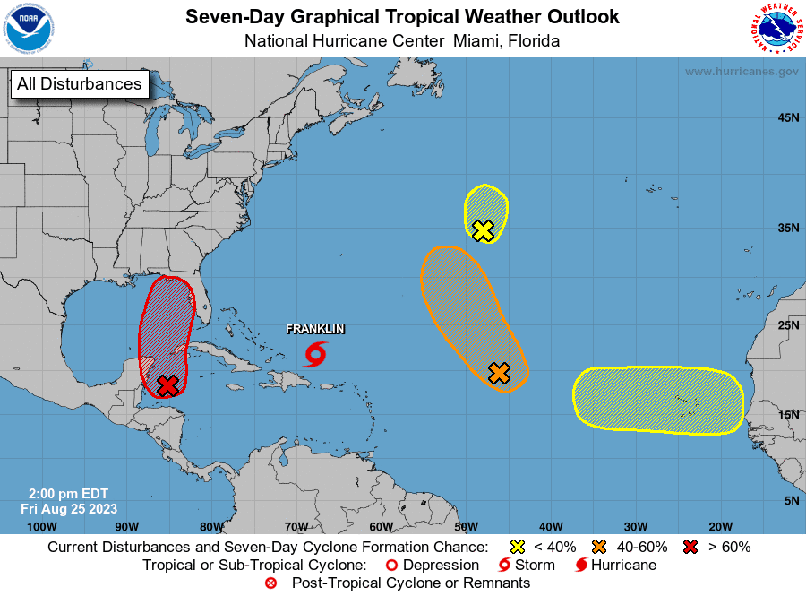
Elsewhere, the Hurricane Center is issuing forecasts on Tropical Storm Franklin located a couple of hundred miles west of Grand Turk Island. Franklin is forecast to track to the west of Bermuda early next week.
NHC is also following the remnants of Emily located over the central subtropical Atlantic, and another area of disturbed weather located midway between the Cabo Verde Islands and the northern Leeward Islands. Neither system poses a threat to the Gulf of Mexico over the next week.
A tropical wave is forecast to move off the west coast of Africa early next week. Some slow development of this system is then possible late next week while the system moves westward across the tropical Atlantic.
Catch Jupiter and Saturn Now in the Evening Sky
Jupiter rises about an hour after dark. Watch for it to come up low in the east-northeast sky. Jupiter shines highest in the south just before the beginning of dawn.
Saturn rises at sunset and it’s at opposition on August 26th. In late twilight you’ll find Saturn glowing as the brightest thing low in the east-southeast sky. It’s at a fairly good height for telescopic observing by 11 p.m.
Venus (about magnitude –4.6) is now in the morning sky before dawn. Look for it above the horizon due east. It will get higher and easier to find every day through the fall.
Have a good weekend!
Bob
Social Media