Thursday turned out to be the hottest day so far this summer for locations along and just east of Interstate 35. High temperatures included 110 degrees at Austin-Camp Mabry, and 109 degrees at Austin-Bergstrom and Georgetown. San Marcos, New Braunfels, and Burnet all recorded highs of 108 degrees. High temperatures across the Hill Country were generally between 105 and 109 degrees. It was also extremely hot across the coastal plains, were highs were between 101 and 105 degrees!
The main culprit for the extremely hot temperatures continues to be a large and powerful heat dome that remains parked over the southern and south central U.S. Friday’s analysis showed the heat dome centered over eastern Oklahoma. Forecasts call for the center of the heat dome to shift northeast to the middle Mississippi Valley region beginning Sunday and to remain over that area through next Thursday. For Central and South Texas, the extremely hot weather will continue, but we can expect a very slight lowering of high temperature this weekend and early next week as the center of the heat dome shifts further northeast.
- High temperatures Friday are forecast to be between 105 and 108 degrees across the Hill Country and Central Texas regions, and between 100 and 105 degrees across the coastal plains.
- High temperatures Saturday through Monday are forecast to be between 103 and 107 degrees across the Hill Country and Central Texas regions, and between 100 and 103 degrees across the coastal plains.
- High temperatures Tuesday are forecast to be between 98 and 101 degrees across the Hill Country and Central Texas regions, and between 95 and 98 degrees across the coastal plains.
Gulf and Tropical Weather Update
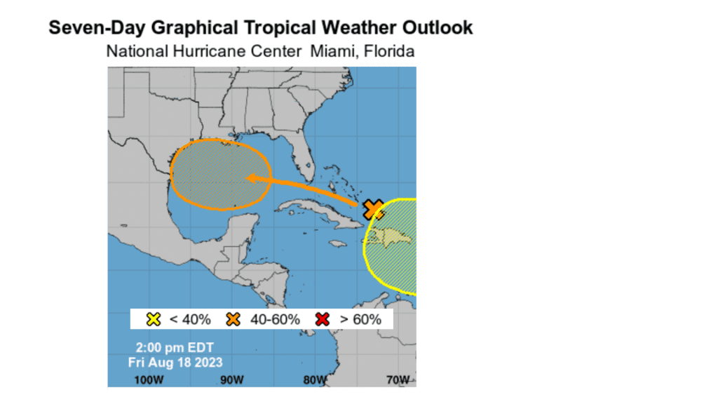 The National Hurricane Center has raised the probability for tropical cyclone development in the western Gulf of Mexico next week to 40 percent, or a medium chance.
National Hurricane Center forecasters continue to monitor a strong tropical wave located over the southern Bahamas that is moving to west. The wave is predicted to reach the eastern Gulf of Mexico late this weekend, then continue westward across the central Gulf Monday. The system is then forecast to approach the Texas coast sometime late Tuesday or Wednesday.
The National Hurricane Center’s Friday midday update calls for a medium chance, or 40 percent probability, for tropical development as the system moves across the Gulf. The various forecast solutions range anywhere from just a tropical wave, to a weak tropical storm when the system moves inland sometime next Tuesday or Wednesday. Conditions do look to be generally favorable for some slow tropical development as the system will be moving over very warm ocean waters. This may end up being a situation where whatever is going to happen with tropical development will occur just before the system moves inland.
The various forecast solutions have come into somewhat better agreement on where this system is expected to move inland. The latest solutions generally point toward the system moving inland somewhere along the middle or lower Texas coast mid-week. I will point out that tracks further north and to the south still cannot be ruled out.
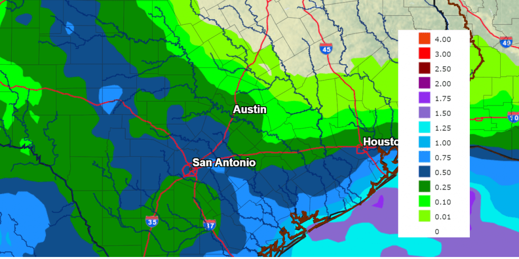
Regardless of whether the system develops into a tropical depression or weak tropical system, it is expected to bring a surge of clouds and tropical moisture onto the middle and lower Texas coast Tuesday into Wednesday. As of now, it appears the highest amount of tropical moisture will remain along and south of the I-10 corridor and west of the Interstate 35 corridor. There will likely be a strong south to north gradient in the probability for rain across the area next week. There is still too much uncertainty to get a good handle on how much rain will fall and over which areas. It will be a battle between the inland-moving moisture and rain bands, and the strong ridge to the north and northeast.
National Weather Service rainfall forecasts call for the highest totals to occur close to the coast, with the lowest totals expected across the northern counties of Central Texas.
NWS Rainfall forecast for the period 7 pm Friday through 7 next Friday:
- High temperatures Wednesday are forecast to be near 98-101 degrees across the Hill Country and Central Texas regions, and in the mid to upper 90s across the coastal plains.
Late Next Week into the Last Week of August
Moisture from the tropical system is forecast to shift to the west and northwest late Wednesday, ending the chance for rain across our region. Meanwhile, the center of the heat dome is predicted to shift southwest and set up somewhere over the southern Plains. Dry and hot weather is forecast. Daily high temperatures are forecast to be between 102 and 105 degrees across the Hill Country and Central Texas regions, and between 98 and 101 degrees across the coastal plains.
Hyperbolic Comet Nishimura
A hyperbolic comet is falling into our solar system. Japanese amateur astronomer Hideo Nishimura discovered it just a few days ago in the constellation Gemini. Although it is relatively dim right now (magnitude +9), Comet Nishimura could soon brighten more than 100-fold to become a naked-eye object in mid-September.
A “hyperbolic comet” is a comet with too much energy to remain trapped inside the solar system. It will visit us only once, with the sun acting as a gravitational slingshot, sending the comet hurtling back into deep space after its flyby.
Because this is Comet Nishimura’s first trip to the inner solar system, it is extra unpredictable. On Sept. 18th, the comet will make its closest approach to the sun deep inside the orbit of Mercury. Anything could happen when intense sunlight touches the comet’s pristine surface for the first time. Possibilities range from dramatic brightening to a disappointing fizzle. Standard models suggest a peak brightness of 3rd magnitude. This would make it visible to the naked eye from rural areas. (Courtesy Spaceweather.com)
Stay tuned for further updates.
Have a great weekend.
Bob
Social Media