Stubborn Heat Dome Will Cause More Dry Weather and Triple-Digit Heat this Week
July 24, 2023
It’s a new week, but we’re still dealing with the same ol’ brutally hot weather pattern. A few lucky folks did see a little rain over the weekend as a weak cold front, or dry air boundary, sagged south out of North Texas. The rainfall coverage was spotty across Central Texas and the coastal plains regions and rain amounts, for the most part, weren’t very heavy. The highest totals occurred across the coastal plains region Sunday where a couple of 1 inch amounts were recorded across parts of Wharton and Matagorda Counties. Unfortunately, the weak boundary had little to no impact on the temperature are widespread triple-digit readings continued across the area.
The primary feature influencing our weather this week will again be the unusually strong heat dome. Monday’s analysis showed the heat dome covering much of the western and central U.S., including Texas. Forecasts call for the heat dome to remain essentially over the same area this week, while expanding east to the Mississippi Valley. The center of the heat dome is currently situated over the Four Corners. It is forecast to shift east to New Mexico and the Texas Panhandle mid-week and remain over the area into the upcoming weekend. With the heat dome continuing this week, few changes in the extremely hot and dry weather pattern can be expected.
Some isolated rain showers and thunderstorms will be possible across the coastal plains region Monday and Tuesday afternoons as a weakness along the eastern periphery of the heat dome will allow the Sea Breeze to push inland to around the Interstate 10 corridor. The rain both days will be spotty in nature, with most locations staying dry. The probability for rain will be 30 percent. Rain amounts are forecast to average around a quarter inch or less. The chance for isolated showers is forecast to diminish during the second half of the week. No rain is forecast this week across Central Texas or the Hill Country.
No significant change in the temperature is forecast throughout the week and the upcoming weekend. The triple-digit readings will continue.
- Daily high temperatures are forecast to be near 103-105 degrees across the Hill Country and Central Texas regions, and near 98-101 degrees across the coastal plains.
Looking ahead to next week and the beginning of August, the forecast solutions are showing few changes in the weather pattern. The heat dome is forecast to remain over Texas and the western U.S., causing more dry and very hot weather. There are no indications at this time the heat dome will be weakening or changing locations through the middle of August.
- Daily high temperatures next week are predicated to be near 103-106 degrees across the Hill Country and Central Texas regions, and near 98-101 degrees across the coastal plains.
Tropical Weather Outlook
Weather conditions are quiet across the Gulf of Mexico and the Caribbean Sea. There are no systems posing a threat the Gulf of Mexico over the next seven days.
Attention continues to be focused on the central tropical Atlantic where a broad area of low pressure associated with a strong tropical wave is moving to the west. This system did not become better organized over the weekend as it encountered quite a bit of dry air. National Hurricane Center forecasters indicate some slow development will still be possible during the next couple of days as the system moves westward across the tropical Atlantic and into the eastern Caribbean Sea. However, the system will be moving into an area with more wind shear.
NHC forecasters are giving this system a low chance (20 percent chance) for tropical development over the next seven days.
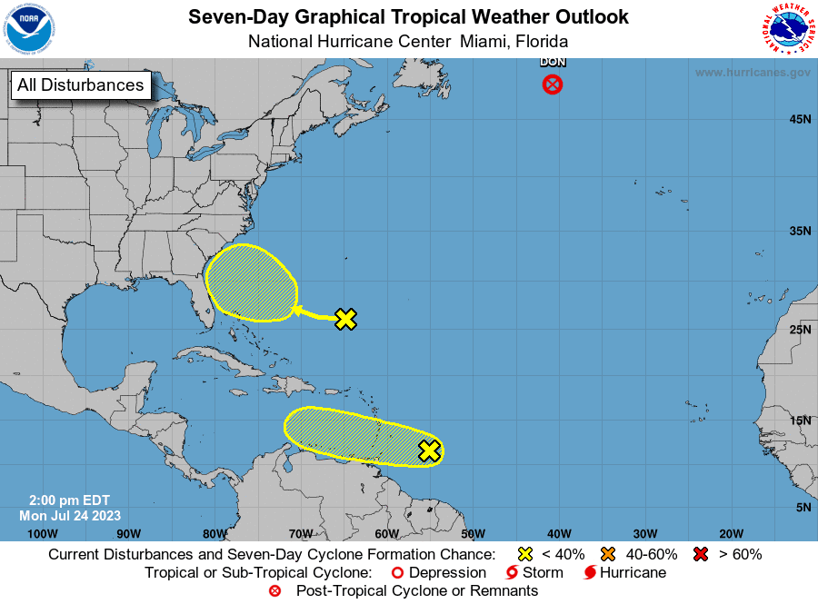
Forecasters are also monitoring a weak trough of low pressure located in the Atlantic, a few hundred miles south of Bermuda. Environmental conditions are expected to become marginally conducive for some gradual development of this system this week and into the weekend as it moves towards the southeastern U.S. coast. NHC forecasters are giving this system a low chance (20 percent chance) for development over the next seven days.
Tropical Storm Don, located over the north Atlantic, has lost sufficient thunderstorm activity to be classified a tropical storm. It was downgraded late Monday morning to Post-Tropical Cyclone. Don was a very long-lasting tropical cyclone (including subtropical stages) for the month of July. Preliminary data from the National Hurricane Center indicates that the storm is the 5th longest-lasting system on record for the month, just behind Emily of 2005.
An Increasing Risk for Wildfires
From the Texas Forest Service:
After a persistent hot and dry weather pattern over the last month, the energy release component has reached the critical 90th percentile for The Western Hill Country, the Eastern Hill Country, Cross Timbers, and Southeast Texas. A High wildfire potential and a moderate potential for large wildfires that are resistant to control efforts is forecast for the Eastern Hill Country, the Western Hill Country and the Cross Timbers this week as elevated fire weather is forecast over critically dry fuels. A Moderate wildfire potential and a low potential for a large wildfire that is resistant to control efforts is forecast for Central Texas, South Texas, the Western Pineywoods, and Southeast Texas this week as elevated fire weather is forecast over dry fuels.
Bob
Social Media