The July heatwave showed no mercy for Central Texas this week. Adding together the maximums and minimums temperatures over the past week, the resultant temperature has averaged among the hottest, if not the hottest on record for the week. Month to date, the temperature has also been averaging close to the hottest on record. Austin-Camp Mabry has recorded 11 consecutive days with the temperature at or above 105 degrees—a new record! The weather pattern across Texas remains very stagnant, and while some minor changes could occur this weekend, more dry and extremely hot weather looks to continue through the end of the month and even into early August.
Friday’s weather maps showed a powerful heat dome continues to cover most of the western and southern U.S. Sinking air on the eastern side of the heat dome is keeping Central Texas weather dry and quite hot. Friday’s weather will again be sunny and hot across the entire region. High temperatures are forecast to be near 101-105 degrees across the Hill Country and Central Texas regions, and near 98-101 degrees across the coastal plains.
The center of the heat dome has spent most of the week over eastern New Mexico and Far West Texas. However, Friday’s analysis showed the center has recently shifted west to eastern Arizona as a trough of low pressure of low pressure, or dip in the jet stream, has strengthened over the eastern U.S. These small changes may open the door for the development of a few spotty light rain showers and just slightly lower temperatures this weekend.
A weak cold front associated with the eastern trough has pushed south into the Texas Panhandle and southern Oklahoma. Forecasts call for the front to slowly sink south to the Concho Valley and North Central Texas tonight, then into the Hill Country and Central Texas Saturday. The front is predicted to stall out somewhere near of just north of Interstate 10 Sunday. Moisture convergence along the boundary may cause the development of a few spotty rain showers across parts of the Hill Country and Central Texas Saturday and Sunday afternoon and evening. The probability for rain at any given location will be less than 20 percent. High temperatures both days are forecast to be near 101-104 degrees.
Across the coastal plains, sunny and hot weather is forecast Saturday. However, scattered rain showers and even a couple of isolated thunderstorms will be possible Sunday into Monday due to the stalled front and an influx or moisture off the Gulf of Mexico. The probability for rain both days is predicted to be around 40 percent. Total rain amounts are forecast to be close to a quarter inch, or less. High temperatures both days are expected to continue around 98-100 degrees.
It will be back to (or a continuation of) very hot and dry weather next week. Forecasts call for the center of the high pressure ridge to shift back to eastern New Mexico and the Texas Panhandle early next week and remain over the area through next weekend. The result will be continued sunny, dry, and very hot weather. High temperatures are forecast to be near 102-106 degrees across the Hill Country and Central Texas regions, and between 98 and 101 degrees across the coastal plains region.
Looking out into the first week of August, today’s forecasts unfortunately show no real change in the weather pattern, with the heat dome remaining centered over the Texas Panhandle region. Dry and very hot weather looks to continue, with little change in the temperature.
Tropical Weather Outlook
Weather conditions are currently quiet across the Gulf of Mexico and the Caribbean Sea. Tropical cyclone development is not expected across this area over the next seven days.
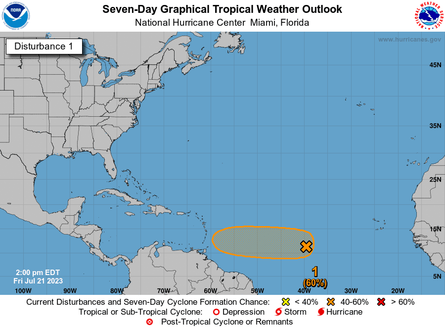
National Hurricane Center forecasters are closely monitoring a small area of low pressure located several hundred miles west-southwest of the Cabo Verde Islands. This system is producing an area of disorganized showers and thunderstorms over the central tropical Atlantic. Although there is dry air located to the north of the system, favorable upper-level winds are expected to allow for gradual development during the next several days. This system could become a tropical depression early next week over the central tropical Atlantic as it moves westward at around 20 mph. NHC is giving this system a medium, or 60 percent chance, for tropical development over the next seven days.
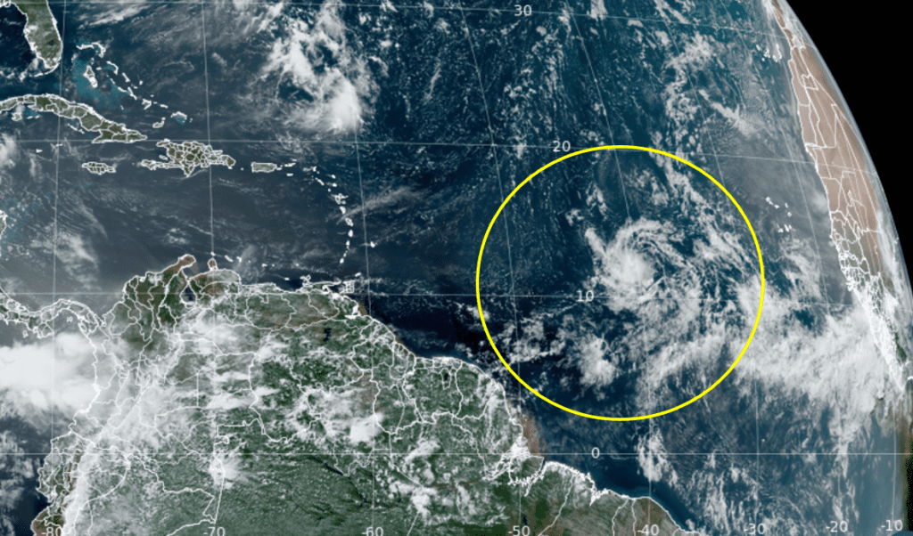
NOAA/Colorado State University/RAMMB 07-21-23 12:30 pm CDT
Tropical Storm Don continues to churn over the north central Atlantic. Don is predicted to remain over the open Atlantic for the next several days, posing no threat to any land areas.
Last Week to View Venus in the Evening Sky
Venus, the very bright planet that has been in the evening sky all summer is about to leave for the morning sky. This next week will be our last opportunity to see Venus in the evening sky until late spring of 2024. Venus is currently low in the western sky after sunset and will be hidden in the sun’s glare by the end of the month.
Have a good weekend.
Bob
Social Media