The Heatwave Will Continue through Next Week. No Rain Forecast
July 14, 2023
We’re closing out one of the hottest weeks so far this summer. The hottest temperatures to date were observed at many locations this week, including Austin, Georgetown, San Marcos, Burnet, and Victoria. Month to date, the temperature is averaging close to 88-90 degrees, and ranks just behind the very hot July recorded in 2022. Unfortunately, the heatwave doesn’t look to be backing down anytime soon. More triple-digit heat is forecast for at least another week.
Friday’s weather maps showed a broad, strong ridge of high pressure in the upper atmosphere covering the southern US. The ridge stretched from southern California to the Carolinas. The center, or most intense part of the ridge, was located over western Arizona and southern California. Although the ridge is currently centered to the west of Texas, its magnitude is still quite intense across Texas.
Forecasts call for the center of the ridge to remain across Arizona, California and Nevada this weekend. Early next week, the center of the ridge is predicted to shift east to the Four Corners region and remain over this general area through late next week and next weekend. The ridge will keep weather features away from South Texas, resulting continued dry weather for at least another week. In addition, temperatures will remain blistering hot!
- High temperatures this afternoon through late next week are forecast to be near 102-106 degrees across the Hill Country and Central Texas regions, and near 98-100 degrees across the coastal plains.
Some slight changes in the weather pattern are forecast to take place the week of July 24th. Forecasts call for a fairly strong and broad trough of low pressure to develop southwest from the Great Lakes to the Lower Mississippi Valley region. The trough will allow a weak cold front to sag south-southwest into Texas, with the front possibly becoming the focus for the development of scattered rain showers and thunderstorms. The various forecast solutions are somewhat optimistic for at some scattered rains that week. Stay tuned for further updates as the forecast models get a better handle on this slight change in the pattern.
The temperature outlook for the week July 24 calls for high temperatures to be close to 100 degrees.
Tropical Weather Outlook
Weather conditions across the tropical Atlantic, the Caribbean Sea, and the Gulf of Mexico are quiet. There are no features in place which pose a threat for tropical cyclone development over the next seven days.
Over the north central tropical Atlantic, the area of low pressure the National Hurricane Center has been monitoring for the past week organized early Friday morning to become Subtropical Storm Don. The storm was assessed as subtropical because it is embedded within an upper-level trough and has a relatively large radius of maximum wind. This system poses no threat to any land areas in the Atlantic.
As of 10 am CDT, the center of Subtropical Storm Don was located 1170 miles west of the Azores. Don was moving toward the north-northwest near 8 mph, and this general motion should continue through Friday night. A turn toward the north is expected Saturday, followed by a turn toward the east by Sunday or Monday. Recent satellite-derived wind data indicate that maximum sustained winds have decreased to near 45 mph with higher gusts. Additional gradual weakening is expected during the next few days, and Don could possibly become a post-tropical cyclone or remnant low at any time.
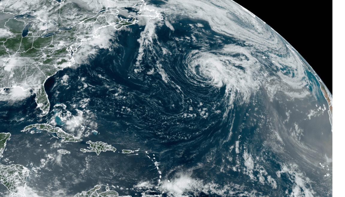
NOAA/Colorado State University/RAMMB 07/14/23 12:50 pm CDT
Have a good weekend!
Bob
Social Media