Our region has experienced a much-deserved break from the extreme heat this week as June’s persistent heat dome finally weakened and shifted to the west. While it hasn’t been a cool wave, the heat has been less oppressive this week with high temperatures staying mostly in the mid and upper 90s.
Another reason for the less-hot weather has been a weak, non-tropical area of low pressure that moved into the northwest Gulf of Mexico. This feature pushed tropical moisture all the way into the Hill Country Thursday, resulting in the development of scattered showers, isolated thunderstorms, and persistent clouds. Most of Thursday’s rain totals were less than a half inch, but a few isolated totals close to an inch were recorded.
Friday’s analysis showed the area of low pressure was still located just off the middle Texas coast. The circulation around the low was again pushing clouds and tropical moisture inland across South Texas. However, moisture levels don’t appear to be quite as high as were observed Thursday, so rain coverage is not expected to be as widespread or as heavy. The most favored area for rain Friday afternoon is expected to be across the coastal plains region, with just a slight chance for rain expected further inland across Central Texas. The probability for rain and isolated thunderstorms will be 50 percent for areas along and south of Interstate 10. Across Central Texas, the chance for rain will be 20 percent. Rain amounts are forecast to average around a quarter inch across the coastal plains, and around a tenth of an inch or less across Central Texas.
Friday’s sky is forecast to be partly cloudy, to occasionally mostly cloudy. High temperatures look to generally be in the mid-90s. Some upper 90s will be possible across parts of the Hill Country.
Forecasts call for the area of low pressure along the middle Texas coast to track inland and dissipate this weekend. Moisture leftover from the system may cause a few isolated afternoon rain showers across the coastal plains region Saturday and Sunday, but the probability for rain will be less than 20 percent.
The weather pattern will be dry and trending hotter this weekend and all of next week as the heat dome, or ridge of high pressure currently centered over the Desert Southwest, strengthens and expands east to cover most of Texas. With the return of the heat dome, another heatwave is expected to take shape across much of the state. Expect a sunny sky this weekend and all of next week.
- High temperatures Saturday and Sunday are forecast to be near 98-100 degrees across the Hill Country and Central Texas regions, and in the mid-90s across the coastal plains.
- High temperatures Monday through next Friday are forecast to be near 100-103 degree across the Hill Country and Central Texas regions, and in the upper 90s across the coastal plains.
Widespread heat index values are predicted to range between 108 and 115 degrees for areas along and east of Interstate 35 beginning Sunday. Heat Advisories are expected to be issued for much of the area by early next week. Proper heat safety will be imperative all of next week.
The outlook for next weekend and the week of July 17th shows few changes as the heat dome is expected to remain over Texas. Daily high temperatures are forecast to remain near 100-103 degrees across the Hill Country and Central Texas regions, and near 98-100 degrees across the coastal plains.
Tropical Weather Outlook
Weather conditions are quiet across the tropical Atlantic, the Caribbean Sea, and the Gulf of Mexico. Satellite images show areas of Saharan dust covering the eastern tropical Atlantic, most of the Caribbean Sea and parts of the Gulf of Mexico. The dust creates a very stable atmosphere and limits the development of potential storms. Some of this dust is expected to spread into the eastern half of Texas early next week.
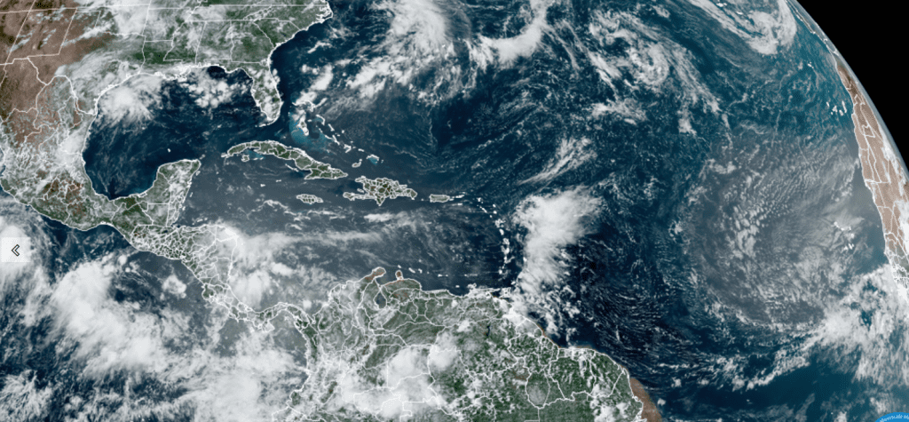
NOAA/Colorado State University/RAMMB 07/07/2023 12:40 pm CDT
Tropical cyclone development is not expected for the next seven days.
Welcoming Jupiter and Saturn back to the Night Sky
After being absent for several months, the planets Jupiter and Saturn have returned to the night sky. However, you will need to stay up late to see them. The bright planet Jupiter rises around 1 or 2 a.m. in the east-northeast sky. By the beginning of dawn it’s shining high in the east. Saturn rises around 11 pm. It’s at its highest in the south and sharpest and steadiest in a telescope just before dawn begins.
Venus remains the “Evening Star”, dominating the western sky in twilight. It’s dropping lower day by day and will be lost from sight by early August.
Have a great weekend.
Bob
Social Media