There’s no mistaking it, summer has arrived! Interestingly, it seemed to happen overnight as there wasn’t much of a transition between highs in the upper 80s last Monday through Thursday and the highs close to the century mark Friday and through the weekend. Now that summer is here, it unfortunately doesn’t look like it will be backing down anytime soon. A summer-like ridge of high pressure centered over central Mexico currently extends north into the southern half of Texas. The ridge is forecast to spread further north across Texas and into Oklahoma late week and into the weekend. As a result, temperatures are predicted to trend a slightly higher beginning Thursday.
High temperatures are forecast to be close to or higher than the century mark each day for the next two weeks.
Parts of the northern Hill Country and the northern counties of Central Texas may see the development of some strong to severe thunderstorms late this afternoon and evening as a wave of low pressure moves across North Texas. Aside from this slim chance for rain and storms, no additional rain is predicted for the rest of this week or next week.
Here’s a detailed breakdown this week’s weather:
Monday through Monday Night
All eyes will be on the Big Country and the northern Hill Country region late this afternoon where scattered strong to severe thunderstorms are forecast to develop when a wave of low pressure arrives from the northwest. Across this area, we will find a stalled out cold front and approaching dry line out of West Texas. This atmospheric set up will be favorable for the development of strong to severe thunderstorms that will then move off to the east-southeast. The Storm Prediction Center has placed parts North Central Texas and the northern Hill Country under a 3 out of 5 risk for severe thunderstorms through Monday evening. A 2 out of 5 risk for severe storms extends south to Mason, Burnet, and Georgetown. A 1 out of 5 risk for severe storms extends south to Fredericksburg, Austin, and College Station.
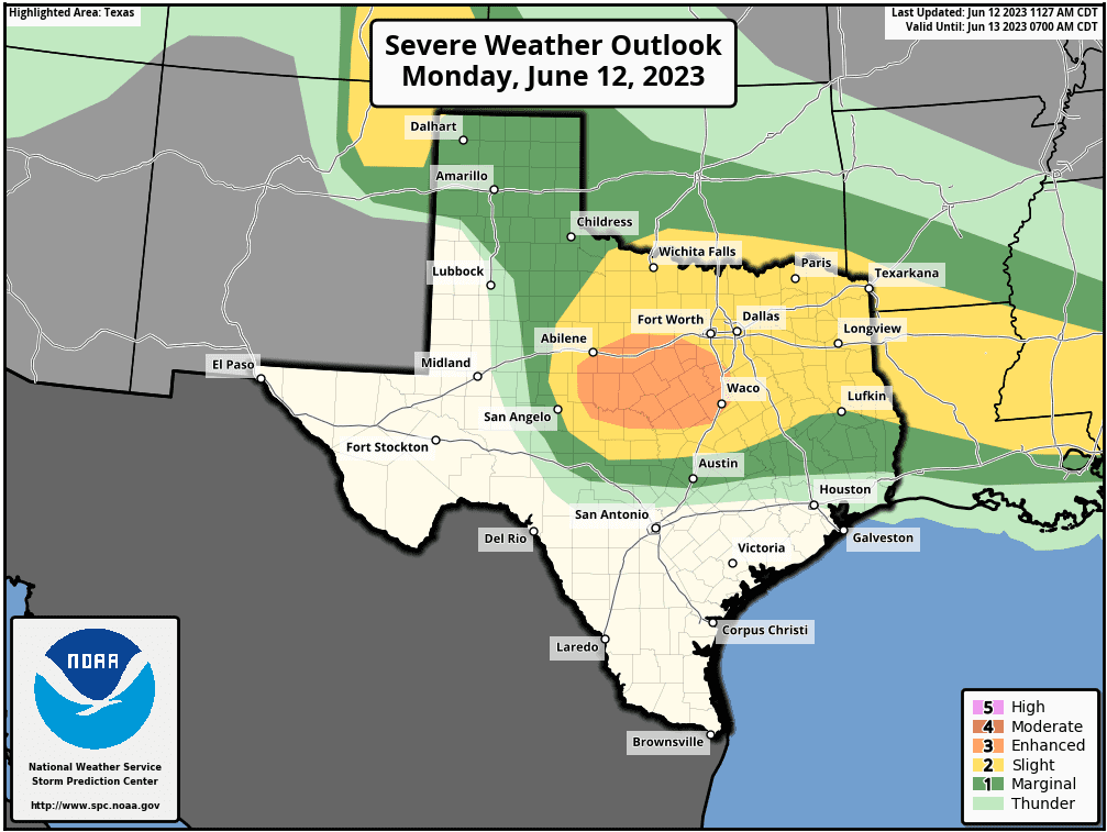
Severe weather threats will include large hail, damaging winds and even a couple of isolated tornadoes.
The developing storms are forecast to move southeast through the evening hours, diminishing by about midnight.
Rain amounts are forecast to average between 0.25 and 0.5 inches, with isolated totals to near 2 inches possible.
Monday’s high temperatures will include the mid and upper 90s across the western and northern Hill Country, along with the coastal plains. High temperatures across Central Texas are forecast to be near 98-100 degrees.
Tuesday through Wednesday
Sunny and hot weather is forecast.
High temperatures will range from the mid-90s across the coastal plains, to the upper 90s to 100 degrees at most other locations.
Thursday through Friday
Sunny and slightly hotter weather is forecast.
High temperatures are predicted to be around 100-103 degrees across the Hill Country and Central Texas regions, and near 100 degrees across the coastal plains.
Saturday through next Wednesday
Sunny and even hotter weather is forecast.
High temperatures are predicted to be near 100-105 degrees across the Hill Country and Central Texas regions, and be around 100 degrees across the coastal plains.
Next Wednesday into the Following Weekend
Sunny and hot weather will continue. Temperatures should moderate down a couple of degrees.
High temperatures are predicted to be near 100-102 degrees across the Hill Country and Central Texas regions, and in the upper 90s across the coastal plains.
Tropical Weather Outlook
Weather conditions are quiet across the tropical Atlantic, the Caribbean Sea, and the Gulf of Mexico. There are no systems in place which pose a threat for tropical development over the next seven days.
An Extended Heat Wave
This is shaping up to be an extended period of extremely hot temperatures! These really hot temperatures have developed rather quickly, so it is a good idea to remind everyone on how to cope with the very hot temperatures.
Remember to drink plenty of fluids, stay in an air-conditioned room if possible, stay out of the sun, and check up on relatives and neighbors. Young children and pets should never be left unattended in vehicles under any circumstances!
Take extra precautions if you work or spend time outside. When possible reschedule strenuous activities to early morning or evening. Know the signs and symptoms of heat exhaustion and heat stroke. Wear lightweight and loose fitting clothing when possible. To reduce risk during outdoor work, the Occupational Safety and Health Administration recommends scheduling frequent rest breaks in shaded or air conditioned environments. Anyone overcome by heat should be moved to a cool and shaded location. Heat stroke is an emergency! Call 9 1 1.
Bob
Social Media