Rain Continues through Friday Night. Dry and Partly Cloudy Weather Expected Easter Sunday
April 7, 2023
This week’s wet pattern has delivered quite a bit of rain to Central Texas and the northern half of the coastal plains! As of mid-morning Friday, totals across this area have generally ranged between 2 and 6 inches, with some of the highest totals occurring across parts of Bastrop, Lee, Fayette, Colorado, and Washington Counties. Although parts of Blanco, Burnet, and Llano Counties have seen totals just of just over an inch, much of the Hill Country has missed out on any significant rain. In addition to the Hill Country, the area to the south of U.S. Highway 59 across the coastal plains has also missed out on any heavy rain.
NWS Estimate of Rain Falling Between 9 am Wednesday and 9 am Friday:
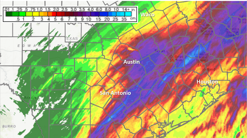
Data courtesy National Weather Service
The wet pattern is predicted to continue across the area this afternoon and tonight, with the rain finally diminishing before sunrise Saturday. No rain is forecast Saturday or Easter Sunday. The next chance for rain is expected to take place Monday into Monday evening as a trough of low pressure tracks south into the state. Rain amounts are forecast to average less than a half inch. Mostly sunny and dry weather looks to follow Tuesday through Friday.
Here’s a breakdown of the outlook:
This Afternoon through Friday Night
A cool, wet, and unsettled pattern will be in place thanks to a very moist atmosphere, a stalled cold front just off the middle Texas coast, and a wave of low pressure tracking east across northern Mexico. Rain showers and scattered thunderstorms have been ongoing across the region throughout the morning hours, with the activity slowly moving to the northeast. Rounds of showers and thunderstorms are forecast to continue this afternoon and through tonight as the trough over Mexico approaches Texas. Increasing atmospheric lift ahead of the trough may cause some of the rain to be moderate to occasionally heavy in intensity. The focus for rain and thunderstorms is again expected to stretch from the eastern Hill Country, to Southeast Texas, including the middle Texas coast.
Additional rain amounts of 1-2 inches are forecast through sunrise Saturday. Totals of 0.25 to 0.5 inches are forecast for the western and northern Hill Country.
The rain is predicted to slowly taper off from west to east after midnight Friday night as the upper trough exits to the east.
- Friday’s temperature will remain somewhat cool, with highs generally in the mid-50s. Upper 50s to low 60s are expected towards the coast.
- Lows Saturday morning will range from the upper 40s across the Hill Country, to the mid and upper 50s across the coastal plains.
Saturday and Saturday Night
Some areas of fog can be expected through about mid-morning Saturday. Otherwise, a mostly cloudy sky is forecast Saturday afternoon through Saturday night. The clouds may thin enough in the afternoon for some peeks at the sun—especially across the Hill Country. The wind will be out of the north at 5-10 mph.
- Saturday’s temperature is forecast to warm to the upper 60s.
- Lows Sunday morning will generally be in the low 50s, with upper 50s to low 60s expected towards the coast.
Easter Sunday and Sunday Night
Widespread low clouds and areas of fog are expected early Sunday morning due to the light wind and the wet ground from recent rains. The clouds should give way to a partly cloudy to mostly sunny sky midday through late afternoon. High temperatures are forecast to be in the upper 60s to low 70s.
The sky is forecast to become cloudy Sunday night. Lows Monday morning will be in the mid and upper 50s.
Monday through Monday Night
There will be a 30-40 percent chance for scattered rain showers and thunderstorms across the region Monday morning through Monday afternoon as a trough of low pressure over the southern plains states sinks south into central Texas. Heavy rain and strong storms are not expected. Mainly just some light to occasionally moderate rain. The sky will be mostly cloudy to occasionally partly cloudy. Rain amounts through early Monday evening are forecast to average between a quarter and a half inch.
The chance for rain should taper off by Monday evening as the trough of low pressure scootches southeast to the upper Texas coast.
High temperatures Monday are forecast to be in the low 70s.
Lows Tuesday morning are forecast to be in the low and mid-50s.
Next Tuesday through Friday
Mostly sunny and dry weather is predicted as the trough over Southeast Texas slowly moves off to the east and a weak ridge of high pressure builds across Texas out of the Desert Southwest.
- High temperatures Tuesday and Wednesday are forecast to be in the mid and upper 70s.
- High temperatures Thursday and Friday are forecast to be in the low 80s.
- Lows Wednesday through Saturday mornings are predicted to be in the mid and upper 50s.
Next Weekend
Forecasts point to a chance for rain developing sometime late next Saturday into Sunday when a trough of low pressure tracks southeast out of the southern Rockies and slowly moves northeast into the Plains states. High temperatures should continue around 80-82 degrees.
Have a good weekend!
Bob
Social Media